Broad Run (conservation area) facts for kids
Quick facts for kids Broad Run |
|
|---|---|
| Location | Craig County Botetourt County Virginia, United States |
| Area | 10,964 acres (44.37 km2) |
| Administrator | U.S. Forest Service |
Broad Run is a special natural area in western Virginia. It's part of the George Washington and Jefferson National Forests. A group called the Wilderness Society thinks it's so important that they call it a "Mountain Treasure." They want to keep it safe from logging and new roads.
Even though it's near New Castle, Broad Run feels like a remote wilderness. It has a very clean stream and three mountains with steep valleys between them. This area is also part of the Craig Creek Cluster of wildlands.
Contents
Getting to Broad Run
Broad Run is located in the Appalachian Mountains of Southwestern Virginia. It's about 4 miles east of New Castle. You can find it between Virginia Route 614 on the west and Route 666 on the east.
There are several trails that lead into the area:
- Ferrier Trail, which is 2.34 miles long
- Lick Branch Trail, which is 5.21 miles long
- North Mountain Trail, which is 13.2 miles long
- Lees Creek Trail, which is 2.71 miles long
You can also get to the area using three roads: Hebron Road (Route 5064), Price Mountain (Route 5012), and Larsen Road (Route 5061).
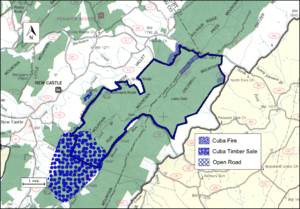
The map next to this text shows the exact boundaries of the Broad Run wildland. You can find more roads and trails on National Geographic Maps 788 (Covington, Alleghany Highlands). If you look at the coordinates at the top right of this page, you can find even more information. This includes topographic maps, aerial views, and satellite data.
Besides the main trails, you can also explore old logging roads. In the early 1900s, people cut down a lot of trees in the Appalachian Mountains. They left behind logging roads that are now getting overgrown but are still usable. You can find these old roads and even old railroad paths by looking at historical maps from the United States Geological Survey (USGS). The Broad Run area is shown on USGS maps called New Castle, Catawba, Oriskany, and Daleville.
Nature and Wildlife
Broad Run is part of a larger natural area known as the Central Appalachian Broadleaf Coniferous Forest-Meadow Province. This means you'll find many different types of trees here.
In the valleys and along streams, you might see yellow poplar, northern red oak, white oak, and red maple trees. On the tops of ridges and in open areas, you'll find chestnut oak, scarlet oak, and yellow pine.
The area is also home to special places like the Lick Branch Barren. This is a unique type of land called a Central Appalachian Shale Barren. It's a special habitat for rare plants, including the Virginia white-haired leatherflower. Another rare plant, the narrow-leaved blue-curls, has also been seen here.
Mountains and Landscape
Broad Run is known for its long, narrow ridges that run from northeast to southwest. These ridges are made of sandstone or shale rock. Between the ridges are parallel valleys with streams flowing into them.
The area has three main ridges: Lick Mountain, Broad Run Mountain, and Caldwell Mountain. These mountains have small, steep valleys on their sides. The highest point is 2,964 feet on Broad Run Mountain. The lowest point is 1,240 feet at Rolands Run Branch.
About 75% of the area has sandstone rock underneath it. The rest of the area has shale rock.
How the Forest Service Manages Broad Run
The U.S. Forest Service looks after Broad Run. They study their lands to see which areas should be protected as "wilderness." Wilderness areas have strong rules to prevent development. Areas that are good for wilderness protection are called "inventoried roadless areas."
Later, a "Roadless Rule" was put in place. This rule limits building new roads in these special areas. It helps protect the environment by reducing the impact of road construction. Broad Run was part of this study, so it's protected from new roads and from being logged for timber.
In 2000, a timber sale called "Cuba" happened on 40 acres of land just north of the wild area. In 2008, a wildfire, also called "Cuba," burned part of Broad Run and a nearby area called Spesard Knob.
The Forest Service also tells visitors what kind of activities they can do in different parts of the forest. The higher parts of Lick Mountain, Broad Run Mountain, and Caldwell Mountain are called "Backcountry-Non Motorized." This means you can hike or explore without vehicles. Some lower areas are for "Dispersed Recreation," where you can spread out and enjoy nature, and some timber can be harvested there. There's also a small section marked as a "Rare Community" because of its unique plants or animals.
History of the Area
People have lived in and used the Broad Run area for a very long time. A survey in 1998 found signs of three temporary camps and a hunting station. These are believed to have been used over 3,000 years ago!
In more recent history, a mining complex from the 1800s was also discovered. This complex included pits where people made charcoal, which was used as fuel.


