
Brochet, Manitoba facts for kids
Quick facts for kids
Brochet
|
|
|---|---|
|
Unincorporated community
|
|

Brochet, Manitoba
Location in Manitoba
|
|
| Country | |
| Province | |
| Region | Northern |
| First established | 1882 |
| Area | |
| • Land | 3.36 km2 (1.30 sq mi) |
| Population
(2016)
|
|
| • Total | 2,410 |
| • Density | 71.6/km2 (185/sq mi) |
Brochet is a small community in Northern Manitoba, Canada. It's located on the northern shore of Reindeer Lake, very close to the Saskatchewan border. Brochet is known as a "northern community."
Most of the people living in Brochet are Cree. It's a bit tricky to get there because there are no roads open all year round. A special winter road is only available for a few months when it's cold enough. The main way to travel to and from Brochet is by air, using the Brochet Airport. Flying from Thompson, Manitoba, takes about an hour. If you use the winter road from Lynn Lake, it can take 4 to 6 hours, depending on how good the road conditions are.
Brochet is one of several small communities in Northern Manitoba. Other places include Granville Lake and South Indian Lake. There are also several First Nations communities nearby, such as Barren Lands First Nation and Northlands First Nation.
History of Brochet
Brochet started as a trading post for the Hudson's Bay Company and a Roman Catholic mission. It was first called Fort du Brochet and appeared on maps in 1883.
In 1924, the name was shortened to Brochet. This name comes from the French word for the northern pike, which is a type of fish. In Manitoba, this fish is often called a "jackfish."
The Cree people who lived in this area historically traveled over a large region. During the time of the fur trade, other trading posts tried to get their business. One nearby trading post was called Le Pensie, or Sandy Hills, but it closed in 1930.
Brochet's Weather
The weather in Brochet can change a lot! It can get very hot or very cold. The hottest temperature ever recorded was 33.5 degrees Celsius (about 92 degrees Fahrenheit) on August 11, 1991. The coldest temperature ever was -51.7 degrees Celsius (about -61 degrees Fahrenheit) on February 15, 1966.
| Climate data for Brochet A, Manitoba, 1988–2006 normals, 1948–2006 extremes: 346m (1135ft) | |||||||||||||
|---|---|---|---|---|---|---|---|---|---|---|---|---|---|
| Month | Jan | Feb | Mar | Apr | May | Jun | Jul | Aug | Sep | Oct | Nov | Dec | Year |
| Record high °C (°F) | 8 (46) |
7 (45) |
11 (52) |
24 (75) |
27 (80) |
32 (89) |
33 (91) |
33 (92) |
27 (81) |
18 (65) |
9 (49) |
6 (42) |
33 (92) |
| Mean maximum °C (°F) | −4.6 (23.7) |
−1.5 (29.3) |
6.6 (43.8) |
12.6 (54.7) |
22.3 (72.1) |
27.1 (80.7) |
28.5 (83.3) |
27.6 (81.7) |
21.8 (71.2) |
12.7 (54.8) |
0.8 (33.5) |
−1.9 (28.6) |
30.1 (86.1) |
| Mean daily maximum °C (°F) | −18.8 (−1.9) |
−15.4 (4.3) |
−7.3 (18.9) |
1.7 (35.1) |
10.1 (50.2) |
18.4 (65.1) |
21.9 (71.4) |
19.5 (67.1) |
11.7 (53.1) |
2.6 (36.7) |
−8.5 (16.7) |
−15.4 (4.2) |
1.7 (35.1) |
| Daily mean °C (°F) | −24.6 (−12.3) |
−21.8 (−7.3) |
−14.2 (6.5) |
−4.9 (23.1) |
3.7 (38.7) |
12.1 (53.7) |
15.8 (60.5) |
14.1 (57.4) |
7.2 (44.9) |
−1.1 (30.0) |
−12.8 (9.0) |
−20.9 (−5.6) |
−4.0 (24.9) |
| Mean daily minimum °C (°F) | −31.2 (−24.1) |
−28.0 (−18.4) |
−21.2 (−6.2) |
−11.4 (11.5) |
−2.3 (27.9) |
5.9 (42.6) |
10.1 (50.1) |
8.9 (48.0) |
2.8 (37.1) |
−4.6 (23.7) |
−16.9 (1.5) |
−26.5 (−15.7) |
−9.5 (14.8) |
| Mean minimum °C (°F) | −44.4 (−48.0) |
−41.9 (−43.4) |
−37.6 (−35.6) |
−24.7 (−12.5) |
−11.6 (11.2) |
−1.6 (29.1) |
3.6 (38.5) |
2.1 (35.7) |
−4.1 (24.6) |
−15.8 (3.6) |
−31.3 (−24.4) |
−41.3 (−42.4) |
−45.8 (−50.5) |
| Record low °C (°F) | −51 (−60) |
−52 (−61) |
−47 (−52) |
−37 (−34) |
−23 (−10) |
−7 (20) |
0 (32) |
−3 (27) |
−11 (12) |
−32 (−25) |
−42 (−44) |
−47 (−53) |
−52 (−61) |
| Average precipitation mm (inches) | 34 (1.35) |
23 (0.92) |
22 (0.88) |
15 (0.60) |
28 (1.12) |
65 (2.56) |
92 (3.63) |
62 (2.44) |
49 (1.91) |
33 (1.29) |
37 (1.44) |
23 (0.92) |
483 (19.06) |
| Average snowfall cm (inches) | 34 (13.5) |
23 (9.2) |
22 (8.8) |
15 (5.8) |
6.1 (2.4) |
0.25 (0.1) |
0.0 (0.0) |
0.0 (0.0) |
1.3 (0.5) |
22 (8.8) |
37 (14.4) |
23 (9.2) |
185 (72.7) |
| Source: XMACIS2 (normals, extremes & precip/snow) | |||||||||||||
Population of Brochet
In 2021, a count of the population was done by Statistics Canada. It showed that 64 people lived in Brochet. This was a change from 118 people in 2016.
Right next to Brochet is the land of the Barren Lands First Nation, which is called Brochet 197. This area had 547 residents. When you combine the people living in Brochet (64 residents) and Brochet 197 (547 residents), it forms a larger "population centre" of 611 people, also known as Brochet.
Images for kids
-
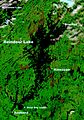
Location of Brochet on a NASA satellite map of Reindeer Lake

