
Brockonbridge Gut facts for kids
Quick facts for kids Brockonbridge Gut |
|
|---|---|


Location of Brockonbridge Gut mouth
|
|
| Other name(s) | Tributary to Delaware Bay |
| Country | United States |
| State | Delaware |
| County | Kent |
| Physical characteristics | |
| Main source | Murderkill River divide Thompsonville, Delaware 9 ft (2.7 m) 38°59′47″N 075°23′54″W / 38.99639°N 75.39833°W |
| River mouth | Delaware Bay Sandy Point, Delaware 0 ft (0 m) 39°02′20″N 075°22′25″W / 39.03889°N 75.37361°W |
| Length | 4.67 mi (7.52 km) |
| Basin features | |
| Progression | northeast |
| River system | Delaware Bay |
| Basin size | 4.55 square miles (11.8 km2) |
| Tributaries |
|
| Bridges | Milford Neck Road, Thompsonville Road, Brockam Bridge Road |
Brockonbridge Gut is a small river, about 4.67 mi (7.52 km) long. It flows into Delaware Bay in Kent County, Delaware. This river is special because it's the only one in the United States with this name!
Contents
What's in a Name?
Sometimes, rivers have different names over time. Brockonbridge Gut was once known as Baucumbrig Creek. This information comes from the Geographic Names Information System. It's a database that keeps track of place names.
Where Does the River Flow?
Brockonbridge Gut starts near Thompsonville, Delaware. This area is close to the Murderkill River. The river then flows towards the northeast. Finally, it reaches and joins the big Delaware Bay at a place called Sandy Point.
The River's Home: Its Watershed
A watershed is like a giant bowl that collects all the water. The Brockonbridge Gut watershed covers about 4.55 square miles (11.8 km2) of land. This area gets a good amount of rain, about 45.0 inches (114.3 cm) every year. About 3.0% of this watershed is covered by forests. These forests help keep the water clean.
Images for kids
-
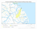
This map shows where Brockonbridge Gut flows and its watershed area.

