Brockton, Montana facts for kids
Quick facts for kids
Brockton, Montana
|
|
|---|---|

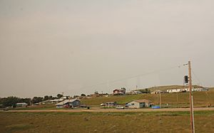
Panorama of Brockton
|
|

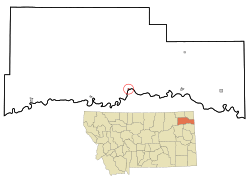
Location of Brockton, Montana
|
|
| Country | United States |
| State | Montana |
| County | Roosevelt |
| Area | |
| • Total | 1.10 sq mi (2.84 km2) |
| • Land | 0.99 sq mi (2.56 km2) |
| • Water | 0.11 sq mi (0.28 km2) |
| Elevation | 1,955 ft (596 m) |
| Population
(2020)
|
|
| • Total | 358 |
| • Density | 361.62/sq mi (139.64/km2) |
| Time zone | UTC-7 (Mountain (MST)) |
| • Summer (DST) | UTC-6 (MDT) |
| ZIP code |
59213
|
| Area code(s) | 406 |
| FIPS code | 30-10000 |
| GNIS feature ID | 2803713 |
Brockton is a small community in Roosevelt County, Montana, United States. It is known as a census-designated place, which means it's a special area defined for counting people. In 2020, about 358 people lived there.
Brockton started with its first post office in 1904. The area grew quickly in 1913. This happened when the Fort Peck Indian Reservation was opened to new settlers who were not Native American. Brockton officially became a town in 1952. However, it stopped being an official town on January 23, 2018.
Contents
Geography of Brockton
Brockton is located in Montana. The United States Census Bureau says the area is about 0.23 square miles (0.6 square kilometers). All of this land is dry land, with no large bodies of water inside the community itself.
What is the Climate Like in Brockton?
The weather near Brockton is measured at a station called Wolf Point 29 ENE. This station is about 12 miles (19.3 km) northwest of Brockton. The climate here is mostly a humid continental climate. This means it has warm summers and cold, snowy winters. It also borders on a cold semi-arid climate, which means it can be quite dry.
| Climate data for Wolf Point 29 ENE, Montana, 1991–2020 normals, 2010-2020 snowfall: 2085ft (636m) | |||||||||||||
|---|---|---|---|---|---|---|---|---|---|---|---|---|---|
| Month | Jan | Feb | Mar | Apr | May | Jun | Jul | Aug | Sep | Oct | Nov | Dec | Year |
| Record high °F (°C) | 60 (16) |
66 (19) |
80 (27) |
88 (31) |
95 (35) |
98 (37) |
111 (44) |
106 (41) |
101 (38) |
89 (32) |
73 (23) |
60 (16) |
111 (44) |
| Mean maximum °F (°C) | 47.4 (8.6) |
47.1 (8.4) |
64.3 (17.9) |
79.1 (26.2) |
86.0 (30.0) |
92.5 (33.6) |
98.7 (37.1) |
98.7 (37.1) |
94.3 (34.6) |
79.9 (26.6) |
63.8 (17.7) |
47.1 (8.4) |
98.1 (36.7) |
| Mean daily maximum °F (°C) | 23.4 (−4.8) |
27.7 (−2.4) |
40.4 (4.7) |
55.8 (13.2) |
66.9 (19.4) |
75.7 (24.3) |
83.6 (28.7) |
83.6 (28.7) |
72.5 (22.5) |
56.1 (13.4) |
39.1 (3.9) |
26.8 (−2.9) |
54.3 (12.4) |
| Daily mean °F (°C) | 11.7 (−11.3) |
16.1 (−8.8) |
28.2 (−2.1) |
41.6 (5.3) |
52.4 (11.3) |
61.6 (16.4) |
68.2 (20.1) |
67.3 (19.6) |
56.3 (13.5) |
41.6 (5.3) |
26.5 (−3.1) |
14.9 (−9.5) |
40.5 (4.7) |
| Mean daily minimum °F (°C) | −0.1 (−17.8) |
4.6 (−15.2) |
16.1 (−8.8) |
27.4 (−2.6) |
37.9 (3.3) |
47.5 (8.6) |
52.9 (11.6) |
51.0 (10.6) |
40.1 (4.5) |
27.2 (−2.7) |
13.9 (−10.1) |
2.9 (−16.2) |
26.8 (−2.9) |
| Mean minimum °F (°C) | −27.4 (−33.0) |
−23.8 (−31.0) |
−9.2 (−22.9) |
10.4 (−12.0) |
21.2 (−6.0) |
35.7 (2.1) |
42.5 (5.8) |
36.7 (2.6) |
23.5 (−4.7) |
9.0 (−12.8) |
−10.4 (−23.6) |
−24.7 (−31.5) |
−32.7 (−35.9) |
| Record low °F (°C) | −43 (−42) |
−47 (−44) |
−32 (−36) |
−6 (−21) |
8 (−13) |
28 (−2) |
38 (3) |
32 (0) |
14 (−10) |
−7 (−22) |
−24 (−31) |
−41 (−41) |
−47 (−44) |
| Average precipitation inches (mm) | 0.43 (11) |
0.30 (7.6) |
0.59 (15) |
1.03 (26) |
2.19 (56) |
2.94 (75) |
2.57 (65) |
1.38 (35) |
1.07 (27) |
0.87 (22) |
0.43 (11) |
0.39 (9.9) |
14.19 (360.5) |
| Average snowfall inches (cm) | 4.4 (11) |
4.2 (11) |
5.9 (15) |
2.3 (5.8) |
0.0 (0.0) |
0.0 (0.0) |
0.0 (0.0) |
0.0 (0.0) |
0.0 (0.0) |
1.2 (3.0) |
3.9 (9.9) |
5.8 (15) |
27.7 (70.7) |
| Source 1: NOAA | |||||||||||||
| Source 2: XMACIS (Brockton 11.6 N snowfall, temp records & monthly max/mins) | |||||||||||||
People Living in Brockton
The number of people living in Brockton has changed over the years. Here's how the population has been counted:
| Historical population | |||
|---|---|---|---|
| Census | Pop. | %± | |
| 1960 | 367 | — | |
| 1970 | 401 | 9.3% | |
| 1980 | 374 | −6.7% | |
| 1990 | 365 | −2.4% | |
| 2000 | 245 | −32.9% | |
| 2010 | 255 | 4.1% | |
| 2020 | 358 | 40.4% | |
| U.S. Decennial Census | |||
What the 2010 Census Showed
In 2010, the census counted 255 people living in Brockton. There were 70 households, which are groups of people living together. Most of the people living in Brockton were Native American. About 3.9% were White. A small number, 1.2%, were Hispanic or Latino.
Many households (65.7%) had children under 18 living with them. The average household had about 3 to 4 people. The average age of people in Brockton was 22.4 years old. This means it's a fairly young community. About 39.2% of residents were under 18.
Getting Around Brockton
The Amtrak train, called the Empire Builder, goes through Brockton. This train travels between Seattle/Portland and Chicago. However, the train does not stop in Brockton. The closest train station is in Wolf Point, Montana, which is about 35 miles (56 km) to the west.
Schools in Brockton
The Brockton School District provides education for students. They teach children from kindergarten all the way through 12th grade. The sports teams for Brockton High School are known as the Warriors.
See also
 In Spanish: Brockton (Montana) para niños
 | May Edward Chinn |
 | Rebecca Cole |
 | Alexa Canady |
 | Dorothy Lavinia Brown |

