
Broke, New South Wales facts for kids
Quick facts for kids BrokeNew South Wales |
|
|---|---|

View of Broke from nearby hills
|
|

Broke
Location in New South Wales
|
|
| Population | 292 (2016 census) |
| Postcode(s) | 2330 |
| Time zone | AEST (UTC+10) |
| • Summer (DST) | AEDT (UTC+11) |
| Location | |
| LGA(s) | Singleton Council |
| Region | Hunter |
| County | Northumberland |
| Parish | Harrowby |
| State electorate(s) | Cessnock |
| Federal Division(s) | Hunter |
Broke is a small village in the Hunter Region of New South Wales, Australia. It's home to about 292 people and is part of the Singleton Shire. You can find it about 157 kilometers (97 miles) north of Sydney. Broke was once an important stop on an old road connecting Sydney to Singleton.
Contents
What's Broke Like?
Broke is famous for its special wines. This area is often called the 'Broke-Fordwich' wine region. It's part of the bigger Hunter Valley wine zone. There's also a lot of coal mining happening nearby. This mining takes place between Broke and Singleton. Every September, the village hosts a fun annual fair.
In Broke, you'll find a primary school, a Catholic church, and an Anglican church. There's also a service station that has a store and a post office. The old brick house next to the store used to be the police station and jail. From the south side of Broke, you can see beautiful views of the Broken Back Range. A cool sandstone rock called Yellow Rock is a main feature of this range.
Broke's Past: A Look Back
Explorers first came to the Broke area in 1818. Land was then given out in 1824. John Blaxland received land because he found a way to the Hunter Valley. Other land grants went to George Blaxland and Robert Rodd. The village got its name from Major Thomas Mitchell. He was the Surveyor General and named it after his English friend, Sir Charles Broke-Vere.
By 1860, John Blaxland had built a mill at nearby Fordwich. Six years later, Broke had an Anglican church, a farm tools workshop, and a school. The Great North Road was finished. It became the main path for moving farm animals to Sydney. Since this road went through Broke, the village grew a lot. About a thousand cattle used the road each week.
All this activity meant that by the late 1800s, Broke had many businesses. It had several hotels, a post office, a school, a mill, two churches, and a hall. There was also a brick kiln, a butchery, a bakery, and a blacksmith.
However, this busy time did not last. Railways eventually took over from the Great North Road. They became the main way to travel between Sydney and the Hunter. This meant much less traffic came through Broke. A railway service was planned between Wollombi and Singleton, but it was never built. Broke went back to being the quiet village it had been before. Still, many important buildings from the early days are still standing. These include the original post office (from 1882) and the village hall (from 1898). The public school (from 1876), the Anglican church, and the Catholic church also remain. You can also see the old police station and what's left of the Blaxland Homestead on Broke Road.
Who Lives in Broke?
In the 2016 Census, there were 239 people living in Broke. Most people, about 87.1%, were born in Australia. Also, 96.6% of people spoke only English at home.
Baiame Cave: Ancient Art
About 12 kilometers (7.5 miles) north-west of Broke, there's a special site. It's about 80 hectares (200 acres) and has rock shelters with several Aboriginal paintings. People believe these paintings show Baiame, the Sky Father. He is thought to have created the world through his dreaming. This site is on private land and is known as Baiame Cave. It is listed on the Register of the National Estate, which means it's an important historical place.
Images for kids
-
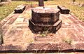
Ruins of Blaxland Homestead, Broke Road
-
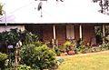
Former police station, Broke Road
-
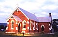
Catholic Church, Broke Road
-
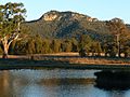
Yellow Rock


