Bronaugh, Missouri facts for kids
Quick facts for kids
Bronaugh, Missouri
|
|
|---|---|

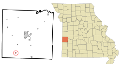
Location of Bronaugh, Missouri
|
|
| Country | United States |
| State | Missouri |
| County | Vernon |
| Area | |
| • Total | 0.29 sq mi (0.75 km2) |
| • Land | 0.28 sq mi (0.74 km2) |
| • Water | 0.00 sq mi (0.01 km2) |
| Elevation | 899 ft (274 m) |
| Population
(2020)
|
|
| • Total | 163 |
| • Density | 571.93/sq mi (220.71/km2) |
| Time zone | UTC-6 (Central (CST)) |
| • Summer (DST) | UTC-5 (CDT) |
| ZIP code |
64728
|
| Area code(s) | 417 |
| FIPS code | 29-08614 |
| GNIS feature ID | 2393422 |
Bronaugh is a small city located in the southwestern part of Vernon County, Missouri, in the United States. According to the 2020 census, 163 people call Bronaugh home.
Contents
What is the History of Bronaugh?
Bronaugh was officially planned and laid out in 1886. This happened when the Nevada and Minden Railway built its tracks to this area. The town got its name from W. C. Bronaugh. He was the person who owned the land where the city was built. A post office opened in Bronaugh in 1886. The city officially became a city in 1897.
Where is Bronaugh Located?
Bronaugh is found along Missouri Route 43. It is about ten miles south-southwest of Nevada. It is also five miles south of the community of Moundville. The Bushwacker Lake Conservation Area is a natural spot nearby. It is located two miles to the southeast.
How Big is Bronaugh?
The United States Census Bureau says Bronaugh is quite small. The city covers a total area of about 0.29 square miles (0.75 square kilometers). All of this area is land.
How Many People Live in Bronaugh?
The number of people living in Bronaugh has changed over the years. Here is a look at the population counts from different census years:
| Historical population | |||
|---|---|---|---|
| Census | Pop. | %± | |
| 1890 | 148 | — | |
| 1900 | 190 | 28.4% | |
| 1910 | 263 | 38.4% | |
| 1920 | 285 | 8.4% | |
| 1930 | 192 | −32.6% | |
| 1940 | 265 | 38.0% | |
| 1950 | 214 | −19.2% | |
| 1960 | 173 | −19.2% | |
| 1970 | 203 | 17.3% | |
| 1980 | 209 | 3.0% | |
| 1990 | 211 | 1.0% | |
| 2000 | 245 | 16.1% | |
| 2010 | 249 | 1.6% | |
| 2020 | 163 | −34.5% | |
| U.S. Decennial Census | |||
What Was the Population in 2010?
The census in 2010 counted 249 people living in Bronaugh. There were 83 households, which are groups of people living together. Out of these, 64 were families. The city had about 858.6 people per square mile. There were 107 housing units, like houses or apartments.
Many households (39.8%) had children under 18 living there. Most households (59.0%) were married couples. Some households had a female (10.8%) or male (7.2%) head without a spouse. About 15.7% of households were individuals living alone. A small number (4.8%) were people aged 65 or older living by themselves. The average household had 3.00 people. The average family had 3.38 people.
The average age of people in Bronaugh was 31.3 years. About 33.7% of residents were under 18. About 28.4% were between 25 and 44 years old. The population was almost evenly split between males (49.0%) and females (51.0%).
See also
 In Spanish: Bronaugh (Misuri) para niños
 | Claudette Colvin |
 | Myrlie Evers-Williams |
 | Alberta Odell Jones |

