
Brooklin, Maine facts for kids
Quick facts for kids
Brooklin, Maine
|
|
|---|---|

Center Harbor in 1909
|
|

Brooklin, Maine
Location in Maine

Brooklin, Maine
Location in the United States
|
|
| Country | United States |
| State | Maine |
| County | Hancock |
| Incorporated | 1849 |
| Villages | Brooklin Haven Naskeag North Brooklin West Brooklin |
| Area | |
| • Total | 41.18 sq mi (106.66 km2) |
| • Land | 17.92 sq mi (46.41 km2) |
| • Water | 23.26 sq mi (60.24 km2) |
| Elevation | 33 ft (10 m) |
| Population
(2020)
|
|
| • Total | 827 |
| • Density | 46/sq mi (17.8/km2) |
| Time zone | UTC-5 (Eastern (EST)) |
| • Summer (DST) | UTC-4 (EDT) |
| ZIP code |
04616
|
| Area code(s) | 207 |
| FIPS code | 23-07800 |
| GNIS feature ID | 0582370 |
Brooklin is a small town located in Hancock County, Maine, United States. In 2020, about 827 people lived there. It is known for its beautiful coastal areas and interesting history.
Contents
History of Brooklin
Brooklin was once part of a larger town called Sedgwick. In 1849, Brooklin decided to become its own separate town. A few weeks later, it was named Brooklin, after a "brook line" that separated it from Sedgwick.
Early settlers used fish oil from a type of fish called "pogie" to help their crops grow in the tough soil. Because of this, hay became a very important crop. However, with its excellent harbors, most people in Brooklin worked in fishing and seafaring (traveling by sea).
By 1859, the town had a population of 1,002 people. It also had five factories that made boots and shoes, and two businesses that made barrels. Later, around 1886, Brooklin became famous for making a lot of smoked herring (a type of fish). Canning lobster also became a big business.
Geography of Brooklin
Brooklin covers a total area of about 41.18 square miles (106.66 square kilometers). A little over half of this area, about 23.26 square miles (60.24 square kilometers), is water. The rest, about 17.92 square miles (46.41 square kilometers), is land.
The town is located on the Eggemoggin Reach, Blue Hill Bay, and the Benjamin River. These waterways are all part of Penobscot Bay, which is a large bay in Maine.
Maine State Route 175 is a main road that goes through the town.
Population and People
The population of Brooklin has changed over the years. Here's how many people have lived there during different census counts:
| Historical population | |||
|---|---|---|---|
| Census | Pop. | %± | |
| 1850 | 1,002 | — | |
| 1860 | 1,043 | 4.1% | |
| 1870 | 966 | −7.4% | |
| 1880 | 977 | 1.1% | |
| 1890 | 1,046 | 7.1% | |
| 1900 | 936 | −10.5% | |
| 1910 | 936 | 0.0% | |
| 1920 | 856 | −8.5% | |
| 1930 | 782 | −8.6% | |
| 1940 | 656 | −16.1% | |
| 1950 | 546 | −16.8% | |
| 1960 | 525 | −3.8% | |
| 1970 | 598 | 13.9% | |
| 1980 | 619 | 3.5% | |
| 1990 | 785 | 26.8% | |
| 2000 | 841 | 7.1% | |
| 2010 | 824 | −2.0% | |
| 2020 | 827 | 0.4% | |
| U.S. Decennial Census | |||
What the 2010 Census Showed
In 2010, there were 824 people living in Brooklin. Most of the people were White (97.9%). The average age of people in the town was about 52.9 years old.
Archaeological Discoveries
The Maine Penny
An interesting discovery was made in Brooklin: an 11th-century Norse coin. This coin was supposedly found at a site where Native Americans used to trade. If this is true, it would be the only physical proof that Norse settlers (like Vikings) ever came to what is now the United States.
However, it's also possible that the coin was not brought directly by Vikings. It might have arrived through trading networks, meaning it was passed from one group of people to another until it reached the area. Some people also wonder if the coin's discovery was a hoax.
Important Historic Places
Brooklin is home to several places that are listed on the National Register of Historic Places. This means they are important to the history of the United States.
- Beth Eden Chapel (added 2001)
- Brooklin IOOF Hall (added 1990)
- Flye Point 2 (added 1985)
- Goddard Site (added 1979)
- E. B. White House (added 1986)
Famous People from Brooklin

Several notable people have lived in or had connections to Brooklin:
- John Wesley Powell: A famous geologist and explorer.
- Oswald Veblen: A well-known mathematician who studied shapes and spaces.
- E. B. White: A beloved author who wrote classic children's books like Charlotte's Web, The Trumpet of the Swan, and Stuart Little.
- James Russell Wiggins: He was the managing editor of The Washington Post newspaper and also served as a United Nations ambassador.
Images for kids
-
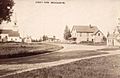
Street view in 1909
-
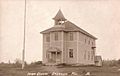
Old High School c. 1915
-
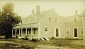
Redman Cottage in 1909


See also
 In Spanish: Brooklin (Maine) para niños
