Brooks Pond (Massachusetts) facts for kids
Quick facts for kids Brooks Pond |
|
|---|---|

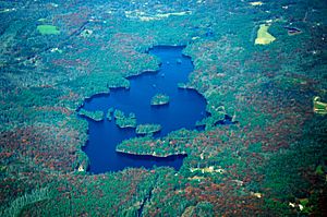
from the air
|
|
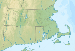
| Location | Worcester County, Massachusetts, United States |
| Coordinates | 42°18′06″N 72°02′31″W / 42.30167°N 72.04194°W |
| Type | Pond |
| Primary outflows | 5.5 ft³/s (0.156 m³/s) |
| Catchment area | 190 acres (77 ha) |
| Basin countries | United States |
| Max. length | ≈2.2 mi (3.54 km) |
| Max. width | ≈1.6 mi (2.57 km) |
| Surface area | ≈3.5 mi² (9.06 km²) |
| Average depth | 12 ft (3.7 m) |
| Max. depth | 20 ft (6.1 m) |
| Shore length1 | ≈4 mi (6.44 km) |
| Surface elevation | 665 ft (203 m) |
| Settlements | New Braintree / North Brookfield / Oakham / Spencer |
| 1 Shore length is not a well-defined measure. | |
Brooks Pond is a special lake in Massachusetts. It's owned and managed privately. Four towns share its borders: North Brookfield, Oakham, Spencer, and New Braintree. This pond is where the Five Mile River begins. This river is part of the larger Chicopee River Watershed.
Contents
All About Brooks Pond
Brooks Pond is mostly shallow. It was made much bigger in 1848 when a dam was built. Its size changed a little again after a big storm, the Hurricane of 1938. The storm washed away a bridge and changed where the water flowed out into the Five Mile River.
How Big Is It?
Originally, Brooks Pond was much smaller, less than 10 acres. It grew a lot because of the dam. Even though it's mostly shallow, some parts can be as deep as 26 feet (8 meters).
Water Quality
The water in Brooks Pond is usually clean. It might look a little colored because of natural leaf tannins. In the summer, the water gets quite warm.
Where Is It Located?
Brooks Pond is in a heavily forested area. It's near a special boundary for water flow. Water to its north and west goes to the Ware River. Water to its south and east goes to the Quaboag River. Many years ago, people mainly had summer homes here. Now, more people live by the pond all year round.
Fishing at Brooks Pond
Fishing at Brooks Pond can be a bit tricky. It's often best for people who have more fishing experience.
What Fish Live Here?
There are many warm-water fish in the pond. However, the large shallow areas can get too warm. They also don't have enough oxygen for bigger fish for most of the year.
Catching Fish
If you're new to fishing, you might mostly catch smaller fish. Some people think the pond has too many fish caught already. But if you know how to find them, you can still catch some good-sized largemouth bass!
 | Kyle Baker |
 | Joseph Yoakum |
 | Laura Wheeler Waring |
 | Henry Ossawa Tanner |


