
Five Mile River (East Brookfield River tributary) facts for kids
Quick facts for kids Five Mile River |
|
|---|---|

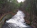
Five Mile River head at Brooks Pond
|
|
| Physical characteristics | |
| Main source | Brooks Pond |
| River mouth | Lake Lashaway 615 feet (187 m) |
| Length | 10.1 miles (16.3 km) |
| Basin features | |
| Basin size | 13.8 square miles (36 km2) |
The Five Mile River is a 10.1-mile long river located in central Massachusetts. It's sometimes called the Fivemile River on official maps. This river is a key part of the larger Chicopee River watershed, meaning its waters eventually join the Chicopee River.
The river begins north of Dean Pond in Oakham, within the Rutland State Forest. From there, it flows south through Dean Pond to Brooks Pond. Brooks Pond is about 2.5 miles northeast of North Brookfield. The Five Mile River then continues its journey south, ending at the northern part of Lake Lashaway, also in North Brookfield.
Contents
About the Five Mile River
The Five Mile River is a short but important waterway. It connects the water flowing out of Brooks Pond to Lake Lashaway. Brooks Pond is located right on the border between the towns of North Brookfield and Spencer. Lake Lashaway is further downstream in North Brookfield.
This river is a tributary (a smaller stream or river that flows into a larger one) of the East Brookfield River. The East Brookfield River then flows into the Quaboag River. All these rivers are part of the larger Chicopee River Watershed.
River's Historical Importance
For many years, the Five Mile River was used as a source of power. Its flowing water helped run sawmills and gristmills (mills that grind grain). Historical records show that it was also used for a colonial foundry.
In 1782, Jonathan and Nicholas Jenks built a blast furnace and iron works near the river. This was a good spot because there was iron ore nearby. The river's power, especially from Brooks Pond (which was known by other names like Johnson's Pond and North Pond), could power a special air-blast bellows. There was also plenty of wood nearby to make charcoal, which was needed for the iron works. Later, two families, the Gilberts and the Jenks, each operated their own furnaces and forges along the river.
Where the River Gets Its Water
Besides Brooks Pond, the Five Mile River also gets water from other places. Water flows into it from the Kittredge Dam Reservoir and the Horse Pond Brook Reservoir. It also collects water from the wetlands (swampy areas) that stretch from Brooks Pond in the north down to Lake Lashaway in the south. The area that drains into the Five Mile River is about 14 square miles, not including the Brooks Pond area.
Images for kids
-
Five Mile River in Spencer

