East Brookfield River facts for kids
Quick facts for kids East Brookfield River |
|
|---|---|

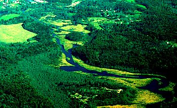
East Brookfield River at East Brookfield
|
|
| Physical characteristics | |
| Main source | Lake Lashaway 614 feet (187 m) |
| River mouth | Quaboag Pond 594 feet (181 m) |
| Length | 2.4 miles (3.9 km) |
| Basin features | |
| Basin size | 15 sq mi (39 km2) |
The East Brookfield River is a small river in Massachusetts. It is about 2.4-mile-long (3.9 km). This river starts at Lake Lashaway in East Brookfield. The lake is about 614 feet (187 m) above sea level. The river then flows into Quaboag Pond, which is about 594 feet (181 m) high.
What is the East Brookfield River?
The East Brookfield River is a short but important waterway. It gets its name from the town of East Brookfield, Massachusetts. This river is part of a larger system. It flows into the Quaboag River. The Quaboag River then joins the Chicopee River. This whole area is called the Chicopee River Watershed. A watershed is an area of land where all the water drains into one main river or lake.
Where Does the River Start and End?
The East Brookfield River begins at the dam of Lake Lashaway. This spot is close to State Route 9. From there, the river flows through wet, marshy areas. It continues its journey until it reaches Quaboag Pond.
How Does the River Get Its Water?
Many smaller streams and brooks feed into the East Brookfield River. These smaller waterways come from nearby towns. Water flows into the river from East Brookfield. It also gets water from North Brookfield. The town of Spencer also contributes water. All this water drains into Lake Lashaway and then into the East Brookfield River.
About one mile before the East Brookfield River reaches Quaboag Pond, another river joins it. This river is called the Seven Mile River. The Seven Mile River brings even more water. It drains areas from Spencer and its surroundings.
 | Emma Amos |
 | Edward Mitchell Bannister |
 | Larry D. Alexander |
 | Ernie Barnes |

