Brooloo, Queensland facts for kids
Quick facts for kids BroolooQueensland |
|||||||||||||||
|---|---|---|---|---|---|---|---|---|---|---|---|---|---|---|---|

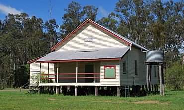
Brooloo Public Hall, established 1915
|
|||||||||||||||
| Population | 369 (2021 census) | ||||||||||||||
| • Density | 13.27/km2 (34.4/sq mi) | ||||||||||||||
| Postcode(s) | 4570 | ||||||||||||||
| Area | 27.8 km2 (10.7 sq mi) | ||||||||||||||
| Time zone | AEST (UTC+10:00) | ||||||||||||||
| Location |
|
||||||||||||||
| LGA(s) | Gympie Region | ||||||||||||||
| State electorate(s) | Gympie | ||||||||||||||
| Federal Division(s) | Wide Bay | ||||||||||||||
|
|||||||||||||||
Brooloo is a small rural town in the Gympie Region of Queensland, Australia. It is also a locality, which is like a local area. In 2021, about 369 people lived in Brooloo.
Contents
Where is Brooloo Located?
Brooloo is in the countryside, behind the Sunshine Coast. It is about 160 kilometers (100 miles) north of Brisbane, the capital city of Queensland.
Roads and Railways in Brooloo
The main road that goes through Brooloo is Mary Valley Road. It enters from the north-west, passes through the town, and then heads out to the south-east.
Brooloo also used to have a railway station. This station was part of the Mary Valley railway line, but the line is now closed.
What is Brooloo's History?
Brooloo has a history that includes its own school, a community hall, and a post office. These places helped the town grow over the years.
Brooloo State School
The first school in the area was called The Bluff Provisional School. It opened in July 1907. A provisional school was a small school that might become a state school later.
- In 1909, it became The Bluff State School.
- In May 1915, its name changed to Brooloo State School.
- The school closed its doors in 1970.
- It was located near where Mary Valley Road and Moy Pocket Road meet.
Brooloo Hall and Post Office
The Brooloo Hall opened in 1915. This hall has been an important place for community events for over a hundred years.
The Brooloo Post Office also opened around June 1915. Before that, there was a smaller "receiving office" from 1914. The post office helped people send and receive mail. It closed in 1972.
Who Lives in Brooloo?
The word "demographics" means information about the people who live in a place, like how many there are. Brooloo's population has slowly grown over the years.
- In 2006, about 333 people lived in Brooloo and the nearby areas.
- By 2016, the population of Brooloo was 348 people.
- In the most recent count in 2021, 369 people lived in the locality of Brooloo.
What are Heritage Listings?
A heritage listing means that a place is very important historically or culturally. It is protected so that future generations can also enjoy and learn from it.
Brooloo Hall: A Heritage Site
Brooloo has one site that is heritage-listed. This special place is the Brooloo Hall, located at 3726 Mary Valley Road. It's recognized for its historical value to the community.
Where Do Brooloo Kids Go to School?
There are no schools directly in Brooloo itself. Students from Brooloo attend schools in nearby towns.
Primary Schools Near Brooloo
For primary school, students can go to:
- Mary Valley State College in Imbil, which is to the north-west.
- Kenilworth State Community College in Kenilworth, to the south.
Secondary Schools Near Brooloo
For secondary school, students have a few options:
- Mary Valley State College in Imbil teaches up to Year 10.
- Gympie State High School in Gympie teaches up to Year 12. Gympie is to the north of Brooloo.
 | Bayard Rustin |
 | Jeannette Carter |
 | Jeremiah A. Brown |


