Brown Fire facts for kids
Quick facts for kids Brown Fire |
|
|---|---|

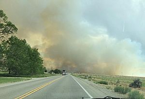
Brown Fire on June 25, 2020
|
|
| Location | Lund, White Pine County, Nevada, United States |
| Coordinates | 38°49′59″N 114°59′17″W / 38.833°N 114.988°W |
| Statistics | |
| Date(s) | June 24, 2020 – June 30, 2020 |
| Burned area | 8,268 acres (3,346 ha) |
| Cause | Unknown |
| Map | |
The Brown Fire was a large wildfire that happened near Lund, Nevada, in the United States. It started on June 24, 2020. This fire burned about 8,268 acres (3,346 ha) of land. That's like burning over 6,000 football fields! Firefighters worked hard to stop it. The fire was fully put out by June 30, 2020.
The fire came very close to Highway 318. It also threatened the southern part of Lund. Because of this, some people living there had to leave their homes for a short time. The exact reason why the fire started is still being investigated.
Contents
How the Brown Fire Started and Grew
The Brown Fire was first reported on June 24, 2020. It began around 3:00 PM EST. The fire was burning on the south and east sides of the small town of Lund, Nevada.
Early Hours of the Fire
When the fire first started, it was estimated to be about 2,000 acres (809 ha). It grew quickly because of dry grass, brush, and trees. The flames moved closer to Lund and along Highway 318.
Evacuations and Road Closures
Because the fire was moving fast, people living on the south side of Lund had to leave their homes. This was a mandatory evacuation to keep everyone safe. Highway 318 was also closed in some areas. This was done to protect drivers and allow firefighters to work. Luckily, residents were able to return to their homes later that same evening.
When the Fire Was Contained
Firefighters worked hard to control the blaze. The Brown Fire was fully contained on June 30, 2020. In total, it burned about 8,268 acres (3,346 ha) of land.
Impacts of the Brown Fire
The Brown Fire had several effects on the local area. Its fast growth caused some immediate concerns.
Evacuation of Lund Residents
The most direct impact was the evacuation of people in southern Lund. This happened on June 24, 2020. It was a safety measure to protect them from the fire. They were allowed to go back home later that night.
Road Closures and Travel
Parts of Highway 318 were closed. This was because the fire was burning very close to the road. These closures helped keep people safe. They also allowed emergency teams to move freely.
Air Quality Concerns
Smoke from the fire traveled far. It affected the air quality in different places. For example, people in Washington County, Utah noticed smoke in the air. This can make it harder to breathe for some people.


