Lund, Nevada facts for kids
Quick facts for kids
Lund, Nevada
|
|
|---|---|
|
Census-designated place
|
|

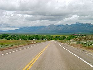
Lund from northbound Nevada State Route 318
|
|
| Country | United States |
| State | |
| County | White Pine |
| Area | |
| • Total | 1.97 sq mi (5.10 km2) |
| • Land | 1.97 sq mi (5.10 km2) |
| • Water | 0.00 sq mi (0.00 km2) |
| Elevation | 5,574 ft (1,699 m) |
| Population
(2020)
|
|
| • Total | 211 |
| • Density | 107.22/sq mi (41.39/km2) |
| Time zone | UTC-8 (Pacific (PST)) |
| • Summer (DST) | UTC-7 (PDT) |
| ZIP codes |
89317
|
| Area code(s) | 775 |
| FIPS code | 32-43400 |
| GNIS feature ID | 2583940 |
Lund is a small town located in White Pine County, Nevada, in the United States. It is a place where the government counts the population, known as a census-designated place. In 2020, about 211 people lived in Lund.
Contents
The Name of Lund
Lund was named after Anthon H. Lund. He was an important official in the Mormon church.
History of Lund
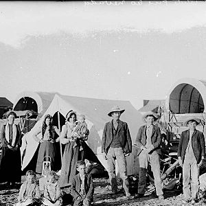
The first lasting settlement in the Lund area began in the early 1870s. The Plane family started it. They were successful by farming, raising horses, and running a dairy. They also operated a waystation, which was a stop for travelers.
Later, James R. Withington took over Tom Plane's ranch. He built the first flour mill in White Pine County. This mill was located at Tom Plane's spring.
Lund was officially settled in 1898. The land was given to the Church of Jesus Christ of Latter-day Saints (LDS Church) by the United States government. This was in exchange for land that had been taken from the church earlier. The first people to settle here were members of the LDS Church. The church still has a local meeting group, called a ward, in Lund today.
The Brown Fire Incident
On June 24, 2020, a large wildfire called the Brown Fire came close to Lund. Because of the fire, people living on the south side of town had to leave their homes for a short time. They were able to return later that same evening. The Brown Fire burned over 8,000 acres (about 3,200 hectares) of land.
Education in Lund
Lund has a combined school system. Lund Elementary School (for grades K-5) and Lund High School (for grades 6-12) are located together. They are known as Lund Combined Schools. These schools are part of the White Pine County School District.
The old Lund Grade School building was built in 1915. It served students for 90 years, until 2005. In 2018, local residents helped get the old school building added to the National Register of Historic Places. This means it is recognized as an important historical site.
Getting Around Lund
Lund is connected by Nevada State Route 318. This state highway passes right through the town. It helps people travel to and from Lund.
Population of Lund
The population of Lund has changed over the years. Here is how many people lived there during recent U.S. Censuses:
| Historical population | |||
|---|---|---|---|
| Census | Pop. | %± | |
| 2010 | 282 | — | |
| 2020 | 211 | −25.2% | |
| U.S. Decennial Census | |||
Climate in Lund
Lund experiences a range of weather throughout the year. Here is a detailed look at the climate data for the area:
| Climate data for Lund, Nevada (1991–2020 normals, extremes 1957–2018) | |||||||||||||
|---|---|---|---|---|---|---|---|---|---|---|---|---|---|
| Month | Jan | Feb | Mar | Apr | May | Jun | Jul | Aug | Sep | Oct | Nov | Dec | Year |
| Record high °F (°C) | 68 (20) |
75 (24) |
80 (27) |
83 (28) |
94 (34) |
99 (37) |
104 (40) |
104 (40) |
95 (35) |
90 (32) |
78 (26) |
69 (21) |
104 (40) |
| Mean maximum °F (°C) | 55.8 (13.2) |
61.0 (16.1) |
68.7 (20.4) |
76.9 (24.9) |
85.3 (29.6) |
92.2 (33.4) |
97.0 (36.1) |
95.3 (35.2) |
89.0 (31.7) |
80.1 (26.7) |
68.6 (20.3) |
58.0 (14.4) |
97.9 (36.6) |
| Mean daily maximum °F (°C) | 42.5 (5.8) |
46.0 (7.8) |
54.4 (12.4) |
60.6 (15.9) |
69.9 (21.1) |
80.8 (27.1) |
88.3 (31.3) |
86.6 (30.3) |
78.4 (25.8) |
65.9 (18.8) |
52.9 (11.6) |
42.2 (5.7) |
64.0 (17.8) |
| Daily mean °F (°C) | 28.1 (−2.2) |
31.7 (−0.2) |
38.6 (3.7) |
44.0 (6.7) |
52.3 (11.3) |
61.3 (16.3) |
68.4 (20.2) |
66.7 (19.3) |
58.9 (14.9) |
47.6 (8.7) |
36.4 (2.4) |
27.5 (−2.5) |
46.8 (8.2) |
| Mean daily minimum °F (°C) | 13.7 (−10.2) |
17.5 (−8.1) |
22.7 (−5.2) |
27.3 (−2.6) |
34.8 (1.6) |
41.9 (5.5) |
48.6 (9.2) |
46.9 (8.3) |
39.5 (4.2) |
29.3 (−1.5) |
20.0 (−6.7) |
12.9 (−10.6) |
29.6 (−1.3) |
| Mean minimum °F (°C) | −0.3 (−17.9) |
1.6 (−16.9) |
10.0 (−12.2) |
15.0 (−9.4) |
23.7 (−4.6) |
32.0 (0.0) |
41.0 (5.0) |
38.7 (3.7) |
29.4 (−1.4) |
18.0 (−7.8) |
5.2 (−14.9) |
−1.3 (−18.5) |
−6.2 (−21.2) |
| Record low °F (°C) | −20 (−29) |
−12 (−24) |
−2 (−19) |
−3 (−19) |
13 (−11) |
23 (−5) |
33 (1) |
32 (0) |
19 (−7) |
5 (−15) |
−11 (−24) |
−17 (−27) |
−20 (−29) |
| Average precipitation inches (mm) | 0.94 (24) |
0.96 (24) |
0.96 (24) |
0.80 (20) |
0.91 (23) |
0.74 (19) |
0.52 (13) |
0.77 (20) |
0.75 (19) |
0.88 (22) |
0.57 (14) |
0.70 (18) |
9.50 (241) |
| Average snowfall inches (cm) | 6.0 (15) |
4.1 (10) |
2.7 (6.9) |
0.8 (2.0) |
0.1 (0.25) |
0.0 (0.0) |
0.0 (0.0) |
0.0 (0.0) |
0.0 (0.0) |
0.0 (0.0) |
1.3 (3.3) |
6.6 (17) |
21.6 (55) |
| Average precipitation days (≥ 0.01 in) | 5.9 | 5.8 | 5.8 | 5.6 | 6.0 | 3.0 | 4.1 | 4.5 | 3.2 | 4.0 | 3.7 | 4.8 | 56.4 |
| Average snowy days (≥ 0.1 in) | 2.1 | 1.9 | 1.2 | 0.4 | 0.1 | 0.0 | 0.0 | 0.0 | 0.0 | 0.0 | 0.6 | 2.0 | 8.3 |
| Source: NOAA (mean maxima/minima 1981–2010) | |||||||||||||
See also
 In Spanish: Lund (Nevada) para niños
 | George Robert Carruthers |
 | Patricia Bath |
 | Jan Ernst Matzeliger |
 | Alexander Miles |


