Brownsville, Ohio facts for kids
Quick facts for kids
Brownsville, Ohio
|
|
|---|---|

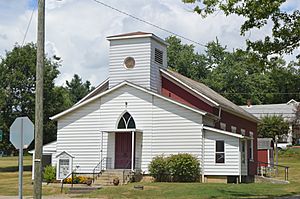
Brownsville United Methodist Church
|
|

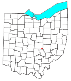
Location of Brownsville in Ohio
|
|
| Country | United States |
| State | Ohio |
| County | Licking |
| Township | Bowling Green |
| Area | |
| • Total | 0.89 sq mi (2.31 km2) |
| • Land | 0.89 sq mi (2.31 km2) |
| • Water | 0.00 sq mi (0.00 km2) |
| Elevation | 1,053 ft (321 m) |
| Population
(2020)
|
|
| • Total | 214 |
| • Density | 240.18/sq mi (92.77/km2) |
| Time zone | UTC-5 (Eastern (EST)) |
| • Summer (DST) | UTC-4 (EDT) |
| ZIP Code |
43721
|
| FIPS code | 39-09596 |
| GNIS feature ID | 2628868 |
Brownsville is a small community in Licking County, Ohio, United States. It's known as a census-designated place (CDP). This means it's an area that the government counts as a community for population statistics, even though it doesn't have its own local government like a city or town.
In 2020, about 214 people lived in Brownsville. The community is located where two important roads meet: U.S. Route 40 and State Route 668.
Contents
History of Brownsville
Brownsville began to grow when the National Road was built through the area. The National Road was one of the first major improved highways in the United States. It helped people travel and transport goods across the country.
The community of Brownsville was officially planned out in 1829. It was named after its founder, a man named Adam Brown. A post office was opened in Brownsville in 1830, which was an important step for the community.
Where is Brownsville?
Brownsville is located in the southeastern part of Licking County. It's about 13 miles (21 km) southeast of Newark, Ohio, which is the main city and county seat of Licking County.
The northern edge of Brownsville is the border between Bowling Green Township and Hopewell Township. To the south, the community follows Interstate 70. You can get onto I-70 from State Route 668, just south of Brownsville. This exit is for traffic going west. If you need to go east on I-70, there's another exit about 2 miles (3.2 km) east in Gratiot, Ohio.
Both I-70 and US-40 can take you to other cities. Traveling east for about 13 miles (21 km) leads to Zanesville, Ohio. Going west for about 41 miles (66 km) will take you to Columbus, Ohio, the state capital.
The total area of Brownsville is about 0.89 square miles (2.31 square kilometers). Most of this area is land, with only a tiny bit of water. Brownsville sits in the valley of Berry Run, a small stream that flows into Valley Run. This water eventually joins the Muskingum River, which flows into the Ohio River.
A cool place nearby is Flint Ridge State Memorial, which is about 3 miles (4.8 km) north of Brownsville. It's a historic site where Native Americans once mined flint.
Population Information
| Historical population | |||
|---|---|---|---|
| Census | Pop. | %± | |
| 2020 | 214 | — | |
| U.S. Decennial Census | |||
The population of Brownsville was counted as 214 people in the 2020 census. A census is like a big count of all the people living in a place, which happens every ten years.
Famous People from Brownsville
- William M. Morgan was a congressman. A congressman is a person who is elected to represent their area in the United States Congress, where they help make laws for the country.
See also
 In Spanish: Brownsville (Ohio) para niños
 | Kyle Baker |
 | Joseph Yoakum |
 | Laura Wheeler Waring |
 | Henry Ossawa Tanner |

