Bucaná facts for kids
Quick facts for kids
Bucaná
|
|
|---|---|

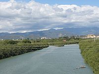
Río Portugués (L) feeds into Río Bucaná (R), just north of PR-52 in Barrio Bucaná
|
|

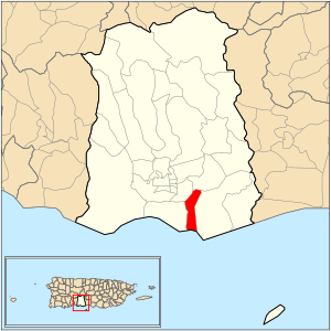
Location of barrio Bucaná within the municipality of Ponce shown in red
|
|
| Commonwealth | |
| Municipality | |
| Area | |
| • Total | 2.16 sq mi (5.6 km2) |
| • Land | 1.37 sq mi (3.5 km2) |
| • Water | 0.79 sq mi (2.0 km2) |
| Elevation | 0 ft (0 m) |
| Population
(2010)
|
|
| • Total | 3,630 |
| • Density | 2,669.1/sq mi (1,030.5/km2) |
| Source: 2010 Census | |
| Time zone | UTC−4 (AST) |
Bucaná is one of the 31 neighborhoods, called barrios, in the city of Ponce, Puerto Rico. It is one of five coastal barrios in Ponce, meaning it touches the sea. The name "Bucaná" comes from a native Indian word. This area was officially established as a barrio in 1831.
Contents
History of Bucaná
Before Bucaná became a barrio of Ponce, around the year 1597, there was a small settlement of European Christians near the Port of Ponce. This place was also called Bucaná.
By 1800, the area was known as Coto Bucaná. A "coto" was a special grant of land given by the Spanish king. These grants were for farming and were a way to thank residents for their service to the king.
Where is Bucaná Located?
Bucaná is an urban barrio, which means it's a developed area within a city. It is located in the southern part of the Ponce municipality. It sits inside the Ponce city limits, southeast of the city's main square, Plaza Las Delicias.
The name of the barrio, toponymy, comes from the Río Bucaná (Bucaná River). This river flows right through the area.
Bucaná's Borders
Bucaná has clear boundaries. To the north, it is bordered by Marginal Street/PR-578. To the south, it meets the Caribbean Sea. On its west side, you'll find the Río Bucaná, PR-2, the Río Portugués, and the channel where the Portugues and Bucaná rivers meet.
To the east, Bucaná is bordered by Bucara Street/Los Caobos Avenue, PR-52, and the access road for the Costa Caribe Country Club. When looking at other barrios, Bucaná is bordered by Sabanetas to the north, the Caribbean Sea to the south, San Anton and Playa to the west, and Vayas to the east.
Population and Area
Bucaná covers about 1.34 square miles (3.47 square kilometers) of land. It also includes about 0.81 square miles (2.10 square kilometers) of water area.
In 2000, Bucaná had a population of 3,963 people. This meant there were about 2,958 people living in each square mile. By 2010, the population was 3,630 people, with about 2,669 people per square mile. Bucaná has the shortest coastline among all five of Ponce's barrios that touch the sea.
Two communities found within Bucaná are Los Caobos and Camino del Sur. Major roads that pass through Bucaná include PR-1, PR-578, and PR-52.
Important Places in Bucaná
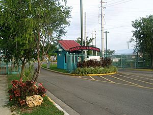
One of the most notable landmarks in Barrio Bucaná is the Julio Enrique Monagas Family Park. It's a great place for families to visit and enjoy outdoor activities.
See also
 In Spanish: Bucaná para niños
- List of communities in Puerto Rico
 | Precious Adams |
 | Lauren Anderson |
 | Janet Collins |


