
San Antón facts for kids
Quick facts for kids
San Antón
|
|
|---|---|
.jpg)
Sign marking an entrance to Barrio San Antón
|
|
| Nickname(s):
"Cuna de la Bomba y Plena" (Birthplace of the Bomba and Plena)
|
|

Location of barrio San Antón within the municipality of Ponce shown in red
|
|

San Antón
Location in Caribbean
|
|
| Commonwealth | |
| Municipality | |
| Area | |
| • Total | 1.16 sq mi (3.0 km2) |
| • Land | 1.13 sq mi (2.9 km2) |
| • Water | 0.03 sq mi (0.08 km2) |
| Elevation | 43 ft (13 m) |
| Population
(2010)
|
|
| • Total | 10,992 |
| • Density | 9,727.4/sq mi (3,755.8/km2) |
| Source: 2010 Census | |
| Time zone | UTC−4 (AST) |
San Antón is a neighborhood, also called a barrio, in Ponce, Puerto Rico. It is one of 31 barrios in the municipality of Ponce. San Antón started as a rural area. Now, it is part of the city of Ponce. It was founded in 1818.
Contents
History of San Antón
San Antón is one of the oldest neighborhoods in Ponce. People believe that Spanish colonists first settled here. It is located on the west side of the Rio Portugues river.
The name San Antón comes from a small chapel. Don Antonio Abad Rodríguez Berrios had this chapel built in the late 1500s. It was built to honor San Antonio Abad, a Catholic saint. The neighborhood was officially organized in 1831. In 2010, the government of Puerto Rico called San Antón the "Birthplace of the plena" (Cuna de la Plena).
Where is San Antón Located?
San Antón is an urban neighborhood. It is in the southern part of the Ponce municipality. It sits within the city limits of Ponce. It is southeast of the main city center, Plaza Las Delicias. The name San Antón is linked to the Catholic saint San Antonio Abad.
San Antón's Borders
San Antón has clear boundaries:
- North: Boulevard Miguel Pou/PR-1 and Nine Street.
- South: PR-2.
- West: Rio Portugues, Emilio Fagot Avenue, and Boulevard Miguel Pou/PR-1.
- East: PR-2 and Rio Bucana.
When looking at other neighborhoods, San Antón is next to:
- North: Machuelo Abajo and Sabanetas.
- South: Playa.
- West: Cuarto, Quinto, and Canas Urbano.
- East: Sabanetas and Bucaná.
People of San Antón
.jpg)
San Antón has about 1.7 square miles (4.4 square kilometers) of land. It also has about 0.1 square miles (0.26 square kilometers) of water. In 2010, about 10,992 people lived in San Antón. This means there were about 9,727 people per square mile.
The communities of Caracoles, Constancia, Jardinet Fagot, Valle Verde, and San Antón (the original area) are all part of this barrio.
The Original San Antón Neighborhood
What the Neighborhood Looks Like
The houses in the original San Antón neighborhood are small and made of wood. They look like "relics from the past." This is very different from the modern, suburban homes in other parts of Ponce, like Constancia. Constancia is right next to the old San Antón. These two very different communities exist side-by-side. San Antón holds onto its traditions strongly.
San Antón's Past
In the 1950s, Ponce saw big economic changes. The city moved from farming to factories. After World War II, the government encouraged new industries. They also built highways and new infrastructure. Many single-family homes were built, and cities grew outwards. The farmlands around San Antón quickly disappeared. Only a small part of the old community remained.
San Antón is often called the "barrio of the freed slaves." It is home to the families of many freed Black people in southern Puerto Rico. Surnames like Roque, Cabrera, and Franceschi connect residents to their 19th-century European and Creole "estate owners." The neighborhood is close to old sugar cane fields. It is also near three large sugar mills: Mercedita, La Fe, and Teresa.
When enslaved people gained freedom in 1873, some received land rights from their former owners. Others moved to San Antón from nearby towns or other Caribbean islands. San Antón is known for its working-class people. It is also famous for its role in developing Puerto Rican music like Bomba and Plena. Many artists, athletes, and heroes have come from this community.
However, in the early 1960s, new government plans led to changes. A large "development" program caused the bigger San Antón barrio to break apart. This also led to a decline in its cultural traditions. Most residents were moved to new housing projects. Others moved north to San Juan or New York City.
Changes Over Time
.jpg)
By the 1960s, the old San Antón was described as having "dilapidated wooden houses." These houses were often covered with scraps of galvanized metal. There were also crooked alleys and abandoned open spaces.
By 1992, the rules for land use in the area changed. It went from being only for homes to an area for "Conceptual Development/Redevelopment." This meant it could be used for businesses, factories, homes, or a mix of these. A new road was planned to go through the community. This road would connect highways to nearby empty lands.
These changes made it clear that time and development were changing San Antón forever. The new roads, higher property values, and its closeness to the city center would bring more businesses.
The 'Ponce en Marcha' Plan
In the early 1990s, Ponce started a big revitalization program. It was called "Ponce en Marcha" (Ponce on the Move). This plan aimed to fix up Ponce's city center. It wanted to bring back the beautiful architecture from the 1800s and early 1900s. The program included the historic zone, transportation, tourism, and city improvements. The city also planned to revitalize several low-income neighborhoods. These included Arenas de Betances and 25 de Enero Street.
San Antón was also part of this revitalization plan. But some people questioned if San Antón deserved it. The city government wanted to "align" (urbanize) the houses in San Antón. They wanted to keep the old look of San Antón. By giving each family its own plot of land, the Housing Office thought San Antón would become more modern. But this really meant changing San Antón's layout to fit the city's plans. The city government was less worried about the social connections and traditions of the neighborhood.
One urban planner disagreed. He said, "San Antón barrio is one of the poorest communities in Ponce. It is in a very bad physical state. However, we must save the neighborhood's social and urban features. San Antón's natural development has helped its quality of life. This quality is still there today, and new urban developments often cannot achieve it."
What Residents Said
Residents did not like the government's plans. For example, Maria Judith Banchs Cabrera, a teacher and San Antón resident, spoke up. She explained that every family's yard had its own special features and way of life. These had developed over many years. She said these traditions were more important than any study the city might have done. The city government realized that moving people from their homes would separate them from their history and ancestors. This would cause problems. They understood that most architects did not see this social side.
San Antón Today
In the end, the City had to agree to most of the residents' demands. The residents, seeing how revitalization helped other neighborhoods, decided to try it too. By 1998, the neighborhood was revitalized. By 2000, about 40 San Antón families moved into new homes. These homes still kept the layout the residents were used to. New water pipes were installed. Street lights, sidewalks, and cul-de-sac roads are now part of San Antón.
San Antón's Legacy
A music video by the famous singer Ednita Nazario was filmed in the renewed community.
Places to Visit in San Antón
San Antón is home to the Ceiba Tree Park. The original San Antón area also has a small park called "Rafael “Caró” Maldonado."
Famous People from San Antón
- Isabel la Negra
- Felix Maldonado
- Luis Antonio ("Mambo") de León Tricoche
- Wichie Torres
- Juan "Papo" Franceschi
- Otto Velez
Images for kids
-
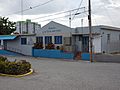
Puerto Rican food restaurant on the campus of Centro del Sur Mall
-
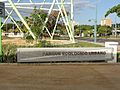
Ecology-themed park on Bulevar Miguel Pou
-
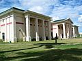
Ponce Municipal Library on Bulevar Miguel Pou
.jpg)
.JPG)
.jpg)
See also
 In Spanish: San Antón (Ponce) para niños
- List of communities in Puerto Rico
