Buckingham Land District facts for kids
Quick facts for kids BuckinghamTasmania |
|||||||||||||||
|---|---|---|---|---|---|---|---|---|---|---|---|---|---|---|---|

Location in Tasmania
|
|||||||||||||||
|
|||||||||||||||
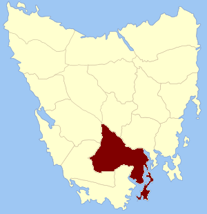
The Buckingham Land District is a special area in Tasmania, an island state of Australia. It's one of the twenty official "land districts" used to help manage land in Tasmania. This district was once known as Buckingham County. It was one of the very first counties created in Tasmania way back in 1836!
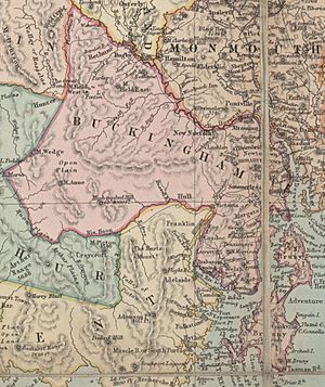
It's bordered by the River Derwent to the north and the Huon River to the south. This district also includes Bruny Island, a large island off the coast of Tasmania. The capital city of Tasmania, Hobart, is located within this area. The district was named after a county in England.
A Look Back: Early Buckingham County
Before the current land district, there was an earlier Buckingham County. This older county existed from 1804 to 1813. During this time, Van Diemen's Land (which is what Tasmania was called back then) was managed as two separate parts.
The original Buckingham County covered all of Van Diemen's Land south of the 42nd parallel. This line stretches across the island from places like Trial Harbour to Friendly Beaches. David Collins was in charge of this southern part. The northern part of the island was called Cornwall County.
How Buckingham County Was Created
On January 15, 1836, George Arthur, who was the Lieutenant Governor of Van Diemen's Land, made an important announcement. He officially declared the first counties and parishes that would be surveyed, or mapped out, in the colony. This announcement was published in The Hobart Town Courier newspaper.
The announcement described the boundaries of the new Buckingham County:
- It was bordered on the north by the River Derwent, from where it meets the River Florentine all the way to the sea.
- To the west, it followed the River Florentine to its source, then a line to the source of the Huon River, and then the Huon River to the sea.
- This county also included many islands, such as Bruni Island, the Egg islands, Huon island, Garden island, Partridge island, Penguin island, Satellite island, Green island, Snake island, Arch island, and Actaeon island. It also included all other islands in D'Entrecasteaux Channel.
At that time, smaller areas called "hundreds" and "parishes" were also created within the county. These were like smaller local areas used for administration and mapping.
Parishes of Buckingham Land District
Today, the Buckingham Land District is divided into many smaller areas called parishes. These parishes help organize the land for mapping and record-keeping purposes. Here is a list of the parishes:
- Anglesea
- Argyle
- Bagot
- Bedford
- Bethune
- Buckingham
- Camden
- Champ
- Conningham
- Glenorchy
- Hobart Town
- Kingborough
- Longley
- Lonna
- Molesworth
- Neena
- New Norfolk
- North Bruny
- Pedder
- Punna
- Queenborough
- Ranelagh
- Rinadena
- South Bruny
- Sutherland
- Throckmorton
- Trinity
- Tyenna
- Uxbridge
- Wellington
 | Shirley Ann Jackson |
 | Garett Morgan |
 | J. Ernest Wilkins Jr. |
 | Elijah McCoy |


