Kent Land District, Tasmania facts for kids
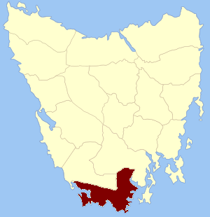
Quick facts for kids KentTasmania |
|||||||||||||||
|---|---|---|---|---|---|---|---|---|---|---|---|---|---|---|---|

Location in Tasmania
|
|||||||||||||||
| LGA(s) | Huon Valley Council | ||||||||||||||
|
|||||||||||||||
Kent Land District is a special area in Tasmania, Australia. It's one of the twenty "land districts" that help divide up the state for maps and official records. Think of it like a historical way of drawing boundaries on a map!
This district is located at the very southern tip of Tasmania. It's bordered by the Huon River to the north and the Picton River to the north-west. Important towns like Dover, Geeveston, and Southport are found here. A big part of the Southwest National Park is also within Kent Land District.
How Kent Land District Was Formed
Back in the early days of Tasmania, which was then called Van Diemen's Land, people needed a way to organize the land. This was important for things like selling land or keeping track of who owned what.
On January 15, 1836, the leader of the island, a man named George Arthur, made an important announcement. He officially created the first "counties" and "parishes." These were the first big divisions of land.
Kent Land District was one of these original areas. Its boundaries were set by natural features like the Davey River, Picton River, and Huon River. The rest of its borders were along the sea. This county also included all the small islands found between Whale Head and North Head near Port Davey.
At that time, no smaller divisions called "hundreds" or "parishes" were created inside Kent County. It was just one large area.
 | Chris Smalls |
 | Fred Hampton |
 | Ralph Abernathy |


