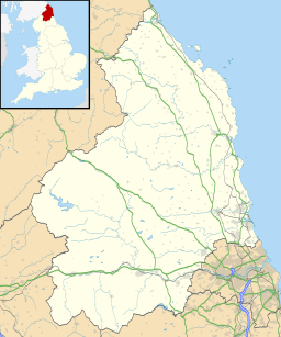
Budle Bay facts for kids
Quick facts for kids Budle Bay |
|
|---|---|
| Location | Northumberland, England, UK |
| OS grid | NZ150360 |
| Coordinates | 55°37′30″N 1°44′42″W / 55.625°N 1.745°W |
Budle Bay is a beautiful bay on the North Sea coast in Northumberland, England. It's about 1.6 kilometers (1 mile) wide. You can find it between the historic village of Bamburgh to the southeast and the famous Lindisfarne (also known as Holy Island) to the northwest.
This bay is a special place for nature and history. It's shaped a bit like a square, opening up to the North Sea on its northeastern side.
Contents
Exploring Budle Bay's Geography
Budle Bay has some interesting features that make it unique. Its eastern edge is called Budle Point. From here, you can see the Bamburgh Castle Golf Club. The popular walking paths, the Northumberland Coast Path and St Oswald's Way, also pass by this area.
Rivers and Waterways
Two small streams, called 'burns' in this part of England, flow into the bay. The Waren Burn enters at the southern corner. A smaller burn, Ross Low, flows in from the western corner. These two streams meet in the intertidal zone, which is the area covered by water at high tide and exposed at low tide. They then continue together towards the sea as Budle Water.
A Home for Wildlife
Budle Bay is a very important natural area. It's part of the Lindisfarne National Nature Reserve. This means it's protected because of its special wildlife and habitats. It's also recognized as a nationally important site for its coastal geomorphology, which is the study of how coastlines are shaped by natural processes like waves and tides.
What's Underneath Budle Bay?
The ground beneath Budle Bay is mostly made of limestone and other types of rock. These rocks are part of something called the Alston Formation. You can't usually see these rocks, except along some parts of the southeastern shore.
Higher up on the southeastern side, you'll find a type of rock called Whin Sill. This rock is very hard and forms the higher ground. There are also large areas of sand, blown by the wind, forming sand dunes. These dunes are especially noticeable at Ross Links on the opposite side of the bay.
A Look Back in Time: Budle Bay's Port
Did you know that Budle Bay used to be a busy seaport? Up until the early 1900s, ships would come and go from here. This port had a few different names over the years, including Waren, Warenmouth, and Warenquay. It played an important role in the local area's trade and transport.
 | Calvin Brent |
 | Walter T. Bailey |
 | Martha Cassell Thompson |
 | Alberta Jeannette Cassell |


