
Bulkley Valley facts for kids
The Bulkley Valley is a beautiful region located in the northwest part of British Columbia, Canada. It's a place with amazing mountains, rivers, and a long history, especially for the Indigenous people who have lived there for thousands of years.
Contents
Geography of the Valley
The Bulkley Valley is found in the central interior of British Columbia. The main river flowing through it is the Bulkley River, which is about 257 kilometers (160 miles) long. This river flows northwest through the valley.
On the west side of the valley, you'll see the Hudson Bay Mountain range. To the east, there are the Babine Mountains. The valley starts in the south near Bulkley Lake, which is between the towns of Houston and Burns Lake. It stretches north to where the Bulkley River joins the larger Skeena River near Hazelton.
History of the Bulkley Valley
First Peoples of the Valley
The Wet'suwet'en people have called the Bulkley Valley home for thousands of years. They are the original inhabitants of this land. In 1997, a very important court decision, known as the Delgamuukw case, confirmed that the Wet'suwet'en and their neighbors, the Gitxsan people, have special land rights in this area.
Early Explorers and Telegraph Lines
The first European to visit the northern part of the valley was likely Simon McGillivray from the Hudson's Bay Company in 1833. Later, in 1859, William Downie explored the area, possibly looking for a route for a railway.
The first people to travel the entire length of the valley were Michael Byrnes and Henry McNeill. They were surveyors for the Collins Overland Telegraph. This telegraph line was a big project meant to connect North America and Europe. The valley and river are named after Charles S. Bulkley, who was the chief engineer for this project. By 1866, the telegraph line had crossed the valley. However, work stopped in 1867 because a successful telegraph cable was laid across the Atlantic Ocean.
Government Surveys and Trails
After the Collins telegraph closed, government surveyors like N. B. Gauvreau (1890–1891) and A. L. Poudrier (1892) explored the valley. Poudrier's team even improved the old telegraph trail, making some parts wide enough for wagons. This made it easier for people to travel through the valley.
Between 1897 and 1901, many prospectors used this trail on their way to the Klondike Gold Rush. They noticed that the Bulkley Valley had good potential for farming and mining. In 1898, the government started a ranch near Houston, and the Hudson's Bay Company started one near Driftwood.
The Yukon Telegraph and New Settlers

Another important telegraph line, the Yukon telegraph, was built through the valley. The second part of this line, which was about 900 kilometers (560 miles) long, was finished in 1901. It followed the old Collins telegraph route. This new telegraph line made it much easier to access the Bulkley Valley.
Some people who worked on the telegraph construction, like Charles Barrett and Edward Charleson, decided to settle in the valley. They bought land and started farms. More settlers slowly arrived, drawn by the valley's potential. In 1904, the community of Aldermere was planned near Telkwa. By 1906, about 74 non-native people lived permanently in the valley.
The government tried to encourage more people to settle by offering land. They even offered land grants to veterans from the Second Boer War. However, many veterans sold their land to large companies or individuals, which slowed down settlement for a while.
Railway and Highway Development

A railway link was very important for the valley's growth. Construction of the Grand Trunk Pacific Railway (GTP) began in 1908 from Prince Rupert and reached the Bulkley Valley in 1912. This railway helped connect the valley to other parts of Canada and made it easier to transport goods and people.
During World War I, land prices dropped, and some settlers left their properties. After the war, in 1917, the BC government encouraged returning soldiers and new settlers to start farms in undeveloped areas of the valley.
The main road through the valley, Highway 16, was improved over many years. By 1925, it was graveled from Prince George to Hazelton. The final section to Prince Rupert was completed in 1944. The highway was widened and paved in the 1960s, making travel much easier.
Mining in the Valley
Mining has also been a part of the Bulkley Valley's history. Coal was mined at Goathorn Creek near Telkwa starting in 1918. Later, Bulkley Valley Collieries became a major coal producer.
There were also mines for precious metals like gold, silver, copper, zinc, and lead. For example, Cronin Mine, which mainly produced silver, was active from 1909 to 1924. Duthie Mines, also known for silver, operated in the 1920s.
More recently, the Huckleberry Mine, an open-pit mine southwest of Houston, opened in 1997. It mainly produced copper and molybdenite. This mine was a big employer in the area, with many workers coming from Bulkley Valley communities. Production stopped in 2016 due to lower metal prices.
Economy of the Bulkley Valley
Today, the main industry in the Bulkley Valley is the forest industry, which involves logging and wood processing. Agriculture is also important, with dairy and beef farms.
The valley is also a great place for tourism. People come here for fishing, hunting, and hiking in the amazing natural scenery. There's also potential for more mining, but residents are careful about new coal mines.
Main Communities in the Valley
The Bulkley Valley is home to several communities along the railway and highway. Some of the main towns and settlements include:
- Houston
- Topley
- Quick
- Barrett
- Walcott
- Knockholt
- Hubert
- Aldermere
- Telkwa
- Tatlow
- Smithers
- Lake Kathlyn
- Evelyn
- Doughty
- Moricetown (renamed Witset in 2018)
- Seaton
- Beament
- Duncanan
Images for kids
-
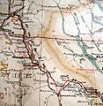
Provincial Government Map, 1923. Cropped to show Bulkley Valley.

