Burgess Falls State Park facts for kids
Quick facts for kids Burgess Falls State Park |
|
|---|---|

Burgess Falls
|
|
| Type | state park |
| Location | Putnam and White counties, Tennessee |
| Area | 350 acres (1.4 km2) |
| Created | 1971 |
| Operated by | Tennessee Department of Environment and Conservation |
| Website | Burgess Falls State Park |
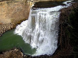
Burgess Falls State Park is a cool state park and natural area in Putnam County and White County, Tennessee, in the southeastern United States. This park is famous for its amazing waterfalls! The Falling Water River flows through a steep gorge here. In less than a mile, the river drops about 250 feet (76 meters). The biggest drop is a huge waterfall called Burgess Falls, which is 136 feet (41 meters) tall.
The Burgess Falls State Natural Area covers 350 acres (1.4 square kilometers). It is managed by the Tennessee Department of Environment and Conservation. This group helps protect the park's natural beauty.
Contents
Discover the Waterfalls of Burgess Falls Park
The Falling Water River starts near the Cumberland Plateau in eastern Putnam County. It then flows across an area called the Highland Rim. Finally, it reaches Center Hill Lake, which is part of the Caney Fork River.
The park is where the river drops from about 900 feet (274 meters) high on the Highland Rim. It goes down to just over 600 feet (183 meters) at Center Hill Lake.
Over many years, the river has carved a deep gorge. The water drops in several steps, getting bigger as it gets closer to Center Hill Lake.
The Amazing Waterfalls
- Falling Water Cascades: This is where the river first spills over rocks. It's a gentle drop of about 10 feet (3 meters).
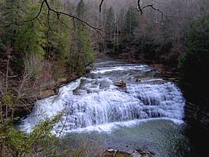
- Little Falls: Right after the Cascades, the river drops another 30 feet (9 meters).
- Middle Falls: Further downstream, you'll find an 80-foot (24-meter) waterfall.
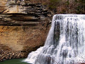
- Burgess Falls: This is the biggest one! It's 136 feet (41 meters) tall. It drops into a large limestone gorge with tall walls.
All these waterfalls are found in less than a mile! The Falling Water River then flows into Center Hill Lake.
A Look Back: History of Burgess Falls
Burgess Falls is named after Tom Burgess. He was a veteran from the American Revolutionary War. Tom Burgess settled near this part of the river in the 1810s.
His family used the river's power to run a gristmill. A gristmill grinds corn into cornmeal. They also had a saw mill to cut lumber for early settlers.
The Old Dam and Electricity
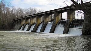
In 1924, the City of Cookeville built a dam on the river. It was about a mile upstream from Burgess Falls. A flood destroyed this dam in 1928.
So, the city built a new concrete dam. This dam provided electricity to the area. It supplied power until 1944, when the Tennessee Valley Authority (TVA) started providing electricity.
People from Cookeville wanted to protect this beautiful area. Because of their efforts, Burgess Falls State Park was created in 1971. You can still see parts of an old pipeline bridge near Little Falls.
Visiting Burgess Falls State Park
The park entrance is off Tennessee State Route 135. It's about halfway between Cookeville and Sparta.
The park is open all year. However, it might close on very rainy days. This is because the Falling Water River can become dangerous when the water level is too high.
Trails and Views
There's a 1.5-mile (2.4-kilometer) loop trail in the park. It follows the cliffs along the south side of the gorge. The trail starts at Falling Water Cascades. It ends at a viewing platform overlooking Burgess Falls.
You can also see Little Falls and Middle Falls from this trail. There are stairs that lead down to the bottom of Burgess Falls. You can even go into the gorge! Another trail follows a ridge southwest of Burgess Falls.
The Burgess Falls State Natural Area also includes Burgess Falls Lake. It covers parts of the forest on both sides of the river near the lake.
 | James Van Der Zee |
 | Alma Thomas |
 | Ellis Wilson |
 | Margaret Taylor-Burroughs |


