Burgin, Kentucky facts for kids
Quick facts for kids
Burgin, Kentucky
|
|
|---|---|

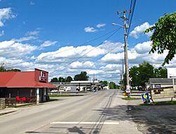
Main Street (KY 152) in Burgin
|
|

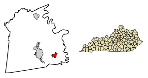
Location of Burgin in Mercer County, Kentucky.
|
|
| Country | United States |
| State | Kentucky |
| County | Mercer |
| Settled | 1877 |
| Incorporated | March 14, 1878 |
| Area | |
| • Total | 1.26 sq mi (3.28 km2) |
| • Land | 1.26 sq mi (3.25 km2) |
| • Water | 0.01 sq mi (0.02 km2) |
| Elevation | 863 ft (263 m) |
| Population
(2020)
|
|
| • Total | 979 |
| • Density | 779.46/sq mi (300.94/km2) |
| Time zone | UTC-5 (Eastern (EST)) |
| • Summer (DST) | UTC-4 (EDT) |
| ZIP code |
40310
|
| Area code(s) | 859 |
| FIPS code | 21-11044 |
| GNIS feature ID | 2403954 |
Burgin is a small city located in Mercer County, Kentucky, in the United States. In 2020, about 979 people lived there. It's a place with a rich history and a close-knit community.
Contents
History of Burgin
How Burgin Got Its Name
The area where Burgin now stands was first known as "Cane Run." This name came from a local stream.
In 1874, a railway company called the Cincinnati Southern Railway needed land for their train tracks. They got permission from a local landowner named Temple Burgin. They then opened a train stop called Burgin Station.
Town Establishment and Growth
The town of Burgin officially started in 1877. It became an incorporated city in 1878. This means it got its own local government.
The post office in the town first opened in 1877 with the name "Bergen." However, in 1886, its name was changed to "Burgin," matching the train station and the town.
Geography of Burgin
Where is Burgin Located?
Burgin is mainly found along Kentucky Route 152, which is also known as Main Street. Most of the public buildings are just west of where this road meets Kentucky Route 33.
Nearby towns include Harrodsburg to the west along KY 152. Danville is to the south along KY 33.
Land and Water Features
The city of Burgin is located at the beginning of Cane Run, which is a stream. This stream flows east into the Dix River.
According to the United States Census Bureau, Burgin covers an area of about 1.2 square miles (3.2 square kilometers). Almost all of this area is land.
Climate in Burgin
Weather in Burgin
Burgin has a type of weather called a humid subtropical climate. This means that the summers are usually hot and humid. The winters are generally mild to cool.
People of Burgin
Population Changes Over Time
The number of people living in Burgin has changed over the years. Here's a look at the population from different census counts:
| Historical population | |||
|---|---|---|---|
| Census | Pop. | %± | |
| 1880 | 150 | — | |
| 1890 | 303 | 102.0% | |
| 1900 | 703 | 132.0% | |
| 1910 | 679 | −3.4% | |
| 1920 | 713 | 5.0% | |
| 1930 | 791 | 10.9% | |
| 1940 | 703 | −11.1% | |
| 1950 | 777 | 10.5% | |
| 1960 | 879 | 13.1% | |
| 1970 | 1,002 | 14.0% | |
| 1980 | 1,008 | 0.6% | |
| 1990 | 1,009 | 0.1% | |
| 2000 | 874 | −13.4% | |
| 2010 | 965 | 10.4% | |
| 2020 | 979 | 1.5% | |
| U.S. Decennial Census | |||
Who Lives in Burgin?
In 2000, there were 874 people living in Burgin. These people lived in 372 different homes. About 29.8% of these homes had children under 18 years old. Many homes were made up of married couples living together.
The average age of people in Burgin in 2000 was 39 years old.
Education in Burgin
Local Schools
Students in Burgin attend schools that are part of the Burgin Independent Schools system.
Famous People from Burgin
Some well-known people have come from Burgin:
- Dillon Carmichael — a singer
- Jack Coleman — a basketball player
- Jacqueline Coleman — a politician
- Marie McDonald — an actress
See also
 In Spanish: Burgin (Kentucky) para niños


