Burton City, Ohio facts for kids
Quick facts for kids
Burton City
|
|
|---|---|

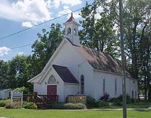
Burton City's United Methodist Church
|
|
| Country | United States |
| State | Ohio |
| County | Wayne |
| Elevation | 1,007 ft (307 m) |
| Time zone | UTC-4 (EST) |
| • Summer (DST) | EDT |
| GNIS feature ID | 1060912 |
Burton City is a small place in Wayne County, Ohio. It is called an unincorporated community. This means it is not officially a city or town with its own local government.
Contents
History of Burton City
How Burton City Got Its Name
Burton City was first started in 1850. Back then, it had a different name: Fairview. In 1852, a post office opened there, and it was called Baughman.
Later, in 1872, the name of the community was changed to Burton City. The post office stayed open for many years but finally closed in 1918.
Where is Burton City?
Location and Surroundings
Burton City is mostly on flat land. It is located about halfway between two other villages, Dalton and Marshallville.
A small stream called Newman Creek flows through the community. This creek eventually joins the Tuscarawas River. Burton City is also close to Orrville. Some online maps even consider it a part of Orrville.
Who Lives in Burton City?
Population Information
Since Burton City is an unincorporated community, its population is not counted separately. The people living in Burton City are included in the population count for Orrville.
Both Burton City and Orrville share the same ZIP code, which is 44667. This is another reason their populations are often grouped together.
Getting Around Burton City
Roads, Trains, and Airports
Burton City does not have any ports for ships. However, freight train tracks run through the community from east to west. These tracks are used by trains that carry goods. The Norfolk Southern company operates these trains.
The main road in Burton City is Ohio State Route 94. This road goes through the community from north to south. It also connects Burton City to bigger highways. You can reach Interstate 76 about fifteen miles to the north. U.S. Route 30 is just three miles to the south.
For air travel, people in Burton City use the Akron–Canton Airport. If they need to travel longer distances, they might use Cleveland Hopkins International Airport.


