Butler, New Jersey facts for kids
Quick facts for kids
Butler, New Jersey
|
||
|---|---|---|
|
Borough
|
||
American Hard Rubber Company
|
||
|
||
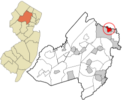
Location of Butler in Morris County highlighted and circled in red (right). Inset map: Location of Morris County in New Jersey highlighted in orange (left).
|
||
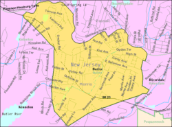
Census Bureau map of Butler, New Jersey
|
||
| Country | ||
| State | ||
| County | ||
| Incorporated | March 13, 1901 | |
| Named for | Richard Butler | |
| Government | ||
| • Type | Borough | |
| • Body | Borough Council | |
| Area | ||
| • Total | 2.06 sq mi (5.34 km2) | |
| • Land | 2.03 sq mi (5.27 km2) | |
| • Water | 0.03 sq mi (0.07 km2) 1.31% | |
| Area rank | 410th of 565 in state 36th of 39 in county |
|
| Elevation | 456 ft (139 m) | |
| Population
(2020)
|
||
| • Total | 8,047 | |
| • Estimate
(2023)
|
8,133 | |
| • Rank | 291st of 565 in state 24th of 39 in county |
|
| • Density | 3,956.2/sq mi (1,527.5/km2) | |
| • Density rank | 160th of 565 in state 5th of 39 in county |
|
| Time zone | UTC−05:00 (Eastern (EST)) | |
| • Summer (DST) | UTC−04:00 (Eastern (EDT)) | |
| ZIP Code |
07405
|
|
| Area code(s) | 973 | |
| FIPS code | 3402709040 | |
| GNIS feature ID | 0885175 | |
Butler is a small town, called a borough, in Morris County, New Jersey. In 2020, about 8,047 people lived there. Butler became an official borough on March 13, 1901. It was formed from parts of Pequannock Township.
Contents
History of Butler: From West Bloomingdale to a Busy Town
The area we know as Butler was once called "West Bloomingdale." Not many people lived here at first. But soon, the power of water from the Pequannock River helped bring factories to the area.
Early Factories and Growth
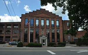
In 1857, the Pequannock Valley Paper Company moved here. Then, in 1868, the Newbrough Hard Rubber Company built a factory. These two companies were very important for the town's growth. They created many jobs.
In 1871, the New Jersey Midland Railroad built train tracks through Butler. This made it easier for people and goods to travel. The railroad helped Butler connect with places like Paterson. Passenger train service ended in 1966, but freight trains still use the tracks today.
How Butler Got Its Name
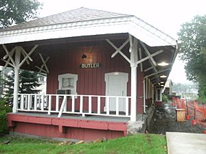
The growing community was named "Butler" in 1881. This was after Richard Butler, who owned the Hard Rubber Company. A Post Office was set up, and a bigger train station was built. This old train station has been the Borough Museum since 1977.
The Hard Rubber Company later joined with other businesses. It became the American Hard Rubber Company in 1898. Another factory, the "Soft" Rubber Company, also opened. More factories and shops came to Butler, and the town kept growing. By 1920, 2,265 people lived here. By 1950, the population had grown to 4,063.
The Great Fire of 1957
Butler had a very big fire on February 26, 1957. It started just after midnight. One of the largest rubber recycling factories, the Pequanoc Rubber Company, was destroyed. The fire caused millions of dollars in damage. It was so bright that people could read a newspaper a mile away at 3 AM! The glow could be seen from 100 miles away. Many volunteer fire departments from nearby towns came to help.
Community Spirit and Tri-Boro Organizations
Butler has many local groups and clubs. Along with the nearby towns of Kinnelon and Bloomingdale, they form "Tri-Boro" organizations. These groups serve all three towns. Examples include the local Little League and the Volunteer First Aid Squad.
Geography of Butler
Butler is a small borough with a total area of about 2.06 square miles (5.34 square kilometers). Most of this area is land, with a small part being water.
Neighboring Towns
Butler shares its borders with several other towns.
- In Morris County, it borders Kinnelon and Riverdale.
- In Passaic County, it borders Bloomingdale and West Milford.
Population Changes in Butler
| Historical population | |||
|---|---|---|---|
| Census | Pop. | %± | |
| 1910 | 2,265 | — | |
| 1920 | 2,886 | 27.4% | |
| 1930 | 3,392 | 17.5% | |
| 1940 | 3,351 | −1.2% | |
| 1950 | 4,050 | 20.9% | |
| 1960 | 5,414 | 33.7% | |
| 1970 | 7,051 | 30.2% | |
| 1980 | 7,616 | 8.0% | |
| 1990 | 7,392 | −2.9% | |
| 2000 | 7,420 | 0.4% | |
| 2010 | 7,539 | 1.6% | |
| 2020 | 8,047 | 6.7% | |
| 2023 (est.) | 8,133 | 7.9% | |
| Population sources: 1910–1920 1910 1910–1930 1940–2020 2000 2010 2020 |
|||
The population of Butler has changed over the years.
- In 1910, there were 2,265 people.
- By 1970, the population had grown to 7,051.
- In 2010, 7,539 people lived in Butler.
- The most recent count in 2020 showed 8,047 residents.
Who Lives in Butler?
According to the 2010 census, most people in Butler (about 89%) were White. About 3% were Asian, and about 1% were Black or African American. About 11% of the population was Hispanic or Latino.
The average age in Butler in 2010 was about 40 years old. About 21% of the people were under 18. About 13% were 65 or older.
Education in Butler
The Butler Public Schools serve students from pre-kindergarten all the way through twelfth grade. In the 2021–22 school year, the school district had about 1,156 students and 109 teachers. This means there were about 10 students for every teacher.
Schools in the District
- Aaron Decker School: This school teaches students from kindergarten to 4th grade. In 2021–22, it had 379 students.
- Richard Butler School: This school is for students in grades 5 through 8. It had 299 students in 2021–22.
- Butler High School: This high school serves students in grades 9 through 12. It had 455 students in 2021–22.
Students from Bloomingdale also attend Butler High School. This is part of a special agreement between the two school districts.
St. Anthony of Padua School was a Catholic school in Butler. It closed in June 2012 because fewer students were enrolling. It had served the community for 130 years.
Transportation in Butler
Butler has a good network of roads and highways.
Main Roads
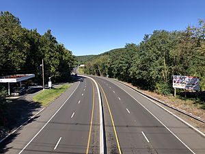
New Jersey Route 23 is the main highway that goes through Butler. County Route 511 also runs through the borough. Interstate 287 is a major highway that passes close to Butler, in nearby towns.
Public Transport
You can take an NJ Transit bus from Butler. The 194 bus route goes to and from the Port Authority Bus Terminal in Midtown Manhattan.
Notable People from Butler
Many interesting people have lived in or are connected to Butler:
- Kurt Adler (1907–1977), a music conductor.
- Frederick Aldrich (1927–1991), a marine biologist known for studying giant squid.
- Harry L. Sears (1920–2002), a politician who served in the New Jersey Legislature.
- Andrew Turzilli (born 1991), a wide receiver who played in the NFL for the Tennessee Titans.
- Gary Wehrkamp (born 1970), a musician, songwriter, and producer. He is a member of the progressive rock band Shadow Gallery.
Points of Interest
- The Butler Museum: This museum is located on Main Street. It is in the old NYS&W railroad station. The museum has exhibits that show the history of the town.
See also
 In Spanish: Butler (Nueva Jersey) para niños
 | James Van Der Zee |
 | Alma Thomas |
 | Ellis Wilson |
 | Margaret Taylor-Burroughs |


