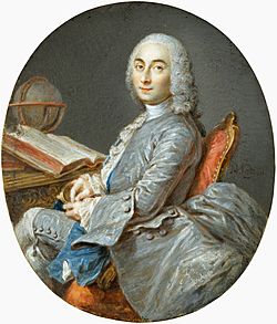
César-François Cassini de Thury facts for kids
Quick facts for kids
César-François Cassini de Thury
|
|
|---|---|

|
|
| Born | 17 June 1714 Thury-sous-Clermont, France
|
| Died | 4 September 1784 (aged 70) Paris, France
|
| Nationality | French |
| Known for | Topographical map of France |
| Children | Jean-Dominique Cassini |
| Scientific career | |
| Fields | Cartography Astronomy |
| Institutions | Paris Observatory |
César-François Cassini de Thury (born June 17, 1714 – died September 4, 1784) was a famous French astronomer and cartographer. He is also known as Cassini III. He came from a family of well-known scientists who worked on mapping and studying the stars.
Contents
About Cassini de Thury
César-François Cassini de Thury was born in a town called Thury-sous-Clermont in France. He was the second son of Jacques Cassini, who was also a famous scientist. His grandfather was Giovanni Domenico Cassini, another very important astronomer. César-François would later become the father of Jean-Dominique Cassini, who continued the family's work.
His Work and Achievements
In 1739, Cassini de Thury became a member of the French Academy of Sciences. This was a big honor for scientists in France. He started as a junior astronomer and later became a full member in 1745. In 1751, he was also chosen to be a member of the Royal Society in London, which is another very old and respected scientific group.
César-François took over his father's important job in 1756. He continued the family's work of surveying and mapping the land.
The Cassini Map of France
One of his biggest achievements was starting a huge topographical map of France in 1744. A topographical map shows the detailed features of the land, like mountains, rivers, and towns. This map was a major step forward in the history of cartography, which is the art and science of making maps.
His son, Jean-Dominique, finished this amazing project. The map was published by the Académie des Sciences between 1744 and 1793. It had 180 detailed plates and is now known as the Cassini map.
Leading the Paris Observatory
In 1771, a new position was created just for him: director of the Paris Observatory. This meant the observatory became its own independent place, not just part of the French Academy of Sciences.
Cassini de Thury also helped start an important project called the Anglo-French Survey (1784–1790). He sent a proposal to the Royal Society in London. This survey aimed to measure the exact distance between the Paris Observatory and the Royal Observatory, Greenwich in England. They used a method called trigonometric survey, which involves measuring angles and distances to create a network of triangles.
His Main Books
Cassini de Thury wrote several important books about his work:
- La méridienne de l’Observatoire Royal de Paris (1744): This book was about correcting the measurements of the Paris meridian, which is an imaginary line running through the Paris Observatory.
- Description géométrique de la terre (1775): This translates to "Geometric Description of the Earth."
- Description géométrique de la France (1784): This means "Geometric Description of France." His son finished this book after his death.
César-François Cassini de Thury passed away in Paris on September 4, 1784, from smallpox, a serious disease common at the time. His work greatly helped improve our understanding of geography and mapping.
See also
- Cassini projection
 | Calvin Brent |
 | Walter T. Bailey |
 | Martha Cassell Thompson |
 | Alberta Jeannette Cassell |

