Cacao Alto facts for kids
Quick facts for kids
Cacao Alto
|
|
|---|---|
|
Barrio
|
|

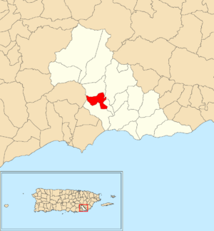
Location of Cacao Alto within the municipality of Patillas shown in red
|
|
| Commonwealth | |
| Municipality | |
| Area | |
| • Total | 1.23 sq mi (3.2 km2) |
| • Land | 1.11 sq mi (2.9 km2) |
| • Water | 0.12 sq mi (0.3 km2) |
| Elevation | 118 ft (36 m) |
| Population
(2010)
|
|
| • Total | 2,449 |
| • Density | 2,206.3/sq mi (851.9/km2) |
| Source: 2010 Census | |
| Time zone | UTC−4 (AST) |
Cacao Alto is a special kind of neighborhood called a barrio. It is located in the town of Patillas, Puerto Rico in Puerto Rico. In 2010, about 2,449 people lived there.
A Look Back: History of Cacao Alto
Puerto Rico used to be controlled by Spain. After the Spanish–American War in 1898, Spain gave Puerto Rico to the United States. This happened because of a special agreement called the Treaty of Paris of 1898. Puerto Rico then became a territory of the United States.
In 1899, the United States government counted all the people in Puerto Rico. They found that the combined population of Cacao Alto and a nearby barrio called Jagual was 1,018 people.
The number of people living in Cacao Alto has changed over the years. Here's how the population has grown:
| Historical population | |||
|---|---|---|---|
| Census | Pop. | %± | |
| 1910 | 481 | — | |
| 1920 | 327 | −32.0% | |
| 1930 | 465 | 42.2% | |
| 1940 | 571 | 22.8% | |
| 1950 | 1,094 | 91.6% | |
| 1980 | 1,252 | — | |
| 1990 | 1,345 | 7.4% | |
| 2000 | 1,566 | 16.4% | |
| 2010 | 2,449 | 56.4% | |
| U.S. Decennial Census 1899 (shown as 1900) 1910-1930 1930-1950 1980-2000 2010 |
|||
More to Explore
- List of communities in Puerto Rico
- List of barrios and sectors of Patillas, Puerto Rico
See also
 In Spanish: Cacao Alto para niños
 | Toni Morrison |
 | Barack Obama |
 | Martin Luther King Jr. |
 | Ralph Bunche |


