
Cahora Bassa Dam facts for kids
Quick facts for kids Cahora Bassa Dam |
|
|---|---|
.jpg)
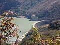
Cahora Bassa Dam, 2007
|
|

Location of Cahora Bassa Dam in Mozambique
|
|
| Location | Tete, Mozambique |
| Coordinates | 15°35′09″S 32°42′17″E / 15.58583°S 32.70472°E |
| Construction began | 1969 |
| Opening date | 1974 |
| Dam and spillways | |
| Impounds | Zambezi River |
| Height | 171 m (561 ft) |
| Reservoir | |
| Creates | Cahora Bassa Lake |
| Total capacity | 55.8 km3 (45,200,000 acre⋅ft) |
| Catchment area | 56,927 km2 (21,980 sq mi) |
| Surface area | 2,739 km2 (1,058 sq mi) |
| Maximum water depth | 157 m (515 ft) |
| Power station | |
| Turbines | 5 × 415 MW (557,000 hp) Francis-type |
| Installed capacity | 2,075 MW (2,783,000 hp) |

The Cahora Bassa Dam is a huge dam located in Mozambique, a country in southern Africa. It's one of the three main dams on the Zambezi River, which is a very important river system. The dam creates a large body of water called Cahora Bassa Lake. This dam is super important because it helps turn the river's power into electricity. This electricity is then sent to cities, farms, and mines, mostly in South Africa. The dam is currently owned by both Mozambique and Portugal. It's the biggest hydroelectric power plant in southern Africa. This means it's the most efficient way to make electricity in Mozambique.
Building the Cahora Bassa Dam

Construction of the Cahora Bassa Dam started in 1969. It was built by the Portuguese government, as Mozambique was a Portuguese territory at the time. The dam is very tall, about 171 meters (561 feet) high. It's also very wide, measuring 303 meters (994 feet) across its top.
The dam began to fill with water in December 1974. When the dam was being built, some local people had to move from their homes. This was to make space for the dam and for the workers who built it. The main goal of the dam was to produce a lot of electricity for South Africa.
After Mozambique became independent, the power lines from the dam were damaged during a long civil war. This war ended in 1992. The lake created by the dam is huge, about 250 kilometers (155 miles) long and 38 kilometers (24 miles) wide. It covers an area of about 2,700 square kilometers (1,042 square miles).
Originally, Portugal owned most of the dam and lake. But in 2007, Portugal sold a large part of its share to Mozambique. Now, Mozambique owns 85 percent, and Portugal owns 15 percent.
How the Dam Makes Power
The Cahora Bassa Dam is the largest hydroelectric system in southern Africa. It has a power station with five big turbines. These turbines are like giant spinning wheels. When water flows through them, they spin and create electricity.
Most of the electricity made here is sent to South Africa. This happens through special power lines called High Voltage Direct Current (HVDC) lines. There are two main stations involved: one in Songo, Mozambique, and another in Apollo, South Africa.
The dam generates about 1,450 megawatts of power. This power travels over 1,800 kilometers (1,100 miles) of these special power lines. These lines have about 4,200 towers in Mozambique alone. They carry electricity at a very high voltage to make sure it reaches South Africa efficiently.
Sometimes, if there isn't enough rain, the water level in the lake can drop. If this happens, the dam operators might have to slow down or even stop the flow of water to the turbines. This helps save water and energy. If the turbines stop, some parts of South Africa might get less electricity. However, places like Songo and Apollo can still get some power from stored energy or by using a method where water is pumped into a reservoir and then released to make electricity when needed.
Images for kids
-
Cahora Bassa Dam, 2007
