Caiguna, Western Australia facts for kids
Quick facts for kids CaigunaWestern Australia |
|
|---|---|

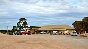
Caiguna Roadhouse
|
|
| Established | 1962 |
| Postcode(s) | 6443 |
| Area | [convert: needs a number] |
| Location | |
| LGA(s) | Shire of Dundas |
| State electorate(s) | Eyre |
| Federal Division(s) | O'Connor |
Caiguna is a small community found along the Eyre Highway in Western Australia. It is mainly a roadhouse, which is like a rest stop for travelers. Caiguna is the second stop east of Norseman. It sits on the long journey across the Nullarbor Plain.
A famous part of the Eyre Highway is between Balladonia and Caiguna. This stretch of road is about 146.6-kilometre (91.1 mi) long. It is one of the longest straight roads in the whole world!
Contents
History of Caiguna
The name Caiguna comes from an Aboriginal word. It might mean "spear track."
Early Explorers
In 1841, an explorer named Edward John Eyre traveled through this area. He was with a man named John Baxter and three Aboriginal companions. They were trying to cross the Nullarbor Plain. During their tough journey, John Baxter died. A memorial to him is located about 10-kilometre (6.2 mi) south of the roadhouse.
Town's Beginning
The townsite of Caiguna was officially started in 1962. This was to help people traveling across the Nullarbor. Many people were driving to Perth for the Commonwealth Games.
In the 1960s and 1970s, big airlines like Ansett and Trans Australia Airlines used Caiguna. They used a special radio station here called a VOR station. This helped their planes navigate on flights between Perth and cities like Adelaide, Melbourne, and Sydney.
Caiguna Today
Today, Caiguna is still mostly a roadhouse. It provides important services for people driving across the Nullarbor.
Roadhouse Facilities
The John Eyre Motel is the main place here. It offers roadhouse services and a basic caravan park. It is one of only three roadhouses on the Nullarbor that are open 24 hours a day. There is also a small landing strip nearby for planes.
The John Eyre Motel is part of the Nullarbor Links golf course. This is the longest golf course in the world! It has one golf tee here, which is a 310-metre (339.0 yd) par 4 hole.
Nearby Attractions
There are interesting natural features close to Caiguna. These include rockholes, blowholes, and gnamma holes. You can find them on tracks off the Eyre Highway. The Caiguna Blowhole is one example. These features formed over many years from the weather changing the limestone rock.
About 13 kilometres (8.1 mi) north-west of Caiguna, you can see the Readymix logo geoglyph. This is a huge design made on the ground. It was created when the Eyre Highway was being paved.
The Nuytsland Nature Reserve is also nearby, stretching along the coast. It has many interesting spots, including another memorial to John Baxter.
Climate and Geography
What is the Climate Like in Caiguna?
Caiguna has a steppe climate. This means it is generally dry, but not a desert. The weather is usually mild, meaning not too hot or too cold. There are only small changes between seasons.
In summer, the average high temperature is about 27 °C (81 °F). In winter afternoons, it's around 18 °C (64 °F). Nights are rarely hot because of the cool air from the ocean.
| Climate data for Eyre | |||||||||||||
|---|---|---|---|---|---|---|---|---|---|---|---|---|---|
| Month | Jan | Feb | Mar | Apr | May | Jun | Jul | Aug | Sep | Oct | Nov | Dec | Year |
| Mean daily maximum °C (°F) | 26.6 (79.9) |
26.6 (79.9) |
25.7 (78.3) |
24.2 (75.6) |
21.4 (70.5) |
19.0 (66.2) |
18.3 (64.9) |
19.5 (67.1) |
21.4 (70.5) |
23.3 (73.9) |
24.5 (76.1) |
25.6 (78.1) |
23.0 (73.4) |
| Mean daily minimum °C (°F) | 15.3 (59.5) |
16.0 (60.8) |
14.2 (57.6) |
11.8 (53.2) |
9.0 (48.2) |
6.7 (44.1) |
5.7 (42.3) |
6.0 (42.8) |
7.6 (45.7) |
10.1 (50.2) |
12.1 (53.8) |
14.1 (57.4) |
10.7 (51.3) |
| Average precipitation mm (inches) | 17.4 (0.69) |
19.5 (0.77) |
27.3 (1.07) |
24.6 (0.97) |
38.2 (1.50) |
39.6 (1.56) |
34.8 (1.37) |
29.6 (1.17) |
23.6 (0.93) |
19.7 (0.78) |
21.3 (0.84) |
21.1 (0.83) |
316.2 (12.45) |
| Source: Australian Bureau of Meteorology | |||||||||||||
 | Charles R. Drew |
 | Benjamin Banneker |
 | Jane C. Wright |
 | Roger Arliner Young |


