Balladonia, Western Australia facts for kids
Quick facts for kids BalladoniaWestern Australia |
|
|---|---|

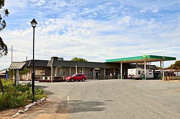
Balladonia Roadhouse, 2017
|
|
| Established | 1879 |
| Postcode(s) | 6443 |
| Area | [convert: needs a number] |
| Location | |
| LGA(s) | Shire of Dundas |
| State electorate(s) | Eyre |
| Federal Division(s) | O'Connor |
Balladonia is a small community in Western Australia. It's a popular stop on the Eyre Highway. This spot is the first major stop east of Norseman. It's also the start of the long journey across the huge Nullarbor Plain. Between Balladonia and Caiguna is a 146.6-kilometre (91.1 mi) stretch of highway. This part is one of the longest straight roads anywhere in the world!
Contents
History of Balladonia
The name "Balladonia" comes from an Aboriginal word. It means "big rock by itself."
Europeans first settled here in 1879. The original Balladonia homestead was built about 28 kilometres (17 mi) from the current town. From 1897 to 1929, Balladonia was a telegraph station. This station was part of the East-West Telegraph line. This line sent messages from Perth to Adelaide. It was important because the old coastal line often stopped working. Salt spray from the Southern Ocean would cause problems.
The weather here is very dry. There isn't much water. This made it hard for the town to grow.
In July 1979, Balladonia became famous worldwide. This happened when parts of the Skylab space station fell to Earth nearby. People found pieces of Skylab scattered across the land.
Balladonia Station: A Big Farm
Balladonia Station is a very large farm. It's called a pastoral lease. It used to be a sheep station, meaning it raised sheep. It's next to other big farms like Noondoonia and Nanambinia.
People wrote about the station in newspapers in 1924. They were worried about rabbits back then. By the 1930s, the main house, or homestead, was quite large. Old photos from the 1890s show stone walls around the homestead.
For most of the 1900s, the station was a popular place to stop. Travellers on the Eyre Highway often visited.
In 2012, the farm changed. It became a cattle station, raising cows instead of sheep. The old building where sheep were shorn was no longer used for that purpose.
In September 2019, a huge area of land was sold. It was called the Balladonia Aggregation. This included Balladonia and three other stations. The total size was 671,277-hectare (1,658,760-acre). It was advertised for $8.5 million, including 5,300 cows.
In September 2021, John Croker was running the station.
Things to See and Do in Balladonia
The Balladonia roadhouse is on the Eyre Highway. It's also known as the Balladonia Hotel Motel. It has a caravan park for people with campers.
The Balladonia Museum is at the roadhouse. It has a display of the Skylab debris. You can also see newspaper clippings about it. The museum shares information about Aboriginal history. It also covers European explorers and settlers. You can learn about the Royal Flying Doctor Service. There's also information on how the Eyre Highway was built. Plus, you can see local plants and animals.
You can drive a four-wheel drive vehicle to the cliffs of the Great Australian Bight. These cliffs are thought to be the longest in the world.
There are also the ruins of the old telegraph station. It's just east of Balladonia. It's at the start of the "Ninety Mile Straight." But, it's on private property.
Afghan Rock: A Historic Water Stop
Near Balladonia, about 14 km (8.7 mi) east, are freshwater pools. These are called Afghan Rock(s). They are named after a cameleer who had a conflict nearby in 1894.
These pools were very important in the 1800s. They provided vital drinking water. This was when goods were moved across the Nullarbor by horses or camels. This was especially true during the Western Australian gold rushes.
On October 13, 1894, a disagreement happened at the rock pools. It involved a group of white men with horses and ""Afghan" cameleers" with camels. The conflict led to the naming of Afghan Rock. The story of this event is in a book called The Ballad of Abdul Wade (2022).
Today, you can reach Afghan Rock with a soft roader vehicle. But you need to ask permission from the Balladonia Station manager first. It is about 447 m (1,467 ft) above sea level.
Balladonia's Climate
Balladonia has a semi-arid climate. This means it's quite dry.
| Climate data for Balladonia | |||||||||||||
|---|---|---|---|---|---|---|---|---|---|---|---|---|---|
| Month | Jan | Feb | Mar | Apr | May | Jun | Jul | Aug | Sep | Oct | Nov | Dec | Year |
| Mean daily maximum °C (°F) | 31.3 (88.3) |
30.6 (87.1) |
28.1 (82.6) |
24.9 (76.8) |
20.9 (69.6) |
18.0 (64.4) |
17.6 (63.7) |
19.2 (66.6) |
22.3 (72.1) |
25.0 (77.0) |
27.8 (82.0) |
30.2 (86.4) |
24.7 (76.5) |
| Mean daily minimum °C (°F) | 14.6 (58.3) |
14.8 (58.6) |
13.5 (56.3) |
10.9 (51.6) |
8.0 (46.4) |
5.8 (42.4) |
4.8 (40.6) |
5.3 (41.5) |
6.8 (44.2) |
8.8 (47.8) |
11.3 (52.3) |
13.2 (55.8) |
9.8 (49.6) |
| Average rainfall mm (inches) | 18.6 (0.73) |
19.4 (0.76) |
27.1 (1.07) |
20.0 (0.79) |
26.9 (1.06) |
26.0 (1.02) |
20.3 (0.80) |
21.4 (0.84) |
20.2 (0.80) |
22.6 (0.89) |
21.9 (0.86) |
18.5 (0.73) |
262.9 (10.35) |
| Average rainy days (≥ 1.0 mm) | 1.9 | 2.0 | 2.8 | 2.7 | 3.4 | 4.0 | 4.0 | 3.7 | 2.8 | 2.6 | 2.5 | 2.0 | 34.4 |
| Source: Australian Bureau of Meteorology | |||||||||||||
 | Calvin Brent |
 | Walter T. Bailey |
 | Martha Cassell Thompson |
 | Alberta Jeannette Cassell |


