Cairo, Nebraska facts for kids
Quick facts for kids
Cairo, Nebraska
|
|
|---|---|
|
Village
|
|

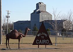
Welcome sign on Nebraska Highway 11 at northern edge of Cairo, December 2009
|
|

Location of Cairo, Nebraska
|
|
| Country | United States |
| State | Nebraska |
| County | Hall |
| Area | |
| • Total | 0.95 sq mi (2.47 km2) |
| • Land | 0.95 sq mi (2.47 km2) |
| • Water | 0.00 sq mi (0.00 km2) |
| Elevation | 1,952 ft (595 m) |
| Population
(2020)
|
|
| • Total | 822 |
| • Density | 862.54/sq mi (333.11/km2) |
| Time zone | UTC-6 (Central (CST)) |
| • Summer (DST) | UTC-5 (CDT) |
| ZIP code |
68824
|
| Area code(s) | 308 |
| FIPS code | 31-07625 |
| GNIS feature ID | 2397524 |
Cairo (say "KAIR-oh") is a small village located in Hall County, Nebraska, in the United States. It's a quiet place with a population of 822 people, according to the 2020 census. Cairo is part of the larger Grand Island area.
Contents
History of Cairo
How Cairo Started
Cairo was founded in 1886. This happened when a railroad, called the Grand Island and Wyoming Central Railroad, built its tracks to this spot. The village was named after Cairo, which is the capital city of Egypt.
Egyptian Theme in Cairo
You might notice that many of the streets in Cairo, Nebraska, have names that remind you of Egypt. This helps keep the "Egyptian" theme alive in the village. Cairo officially became a village in 1892.
Geography of Cairo
Where Cairo is Located
Cairo is located in Hall County, Nebraska. It's a small village in terms of size.
Size of the Village
According to official measurements, the village covers a total area of about 2.47 square kilometers (or 0.95 square miles). All of this area is land, meaning there are no large bodies of water within the village limits.
People of Cairo
Population Over the Years
The number of people living in Cairo has changed over time. Here's a quick look at its population:
| Historical population | |||
|---|---|---|---|
| Census | Pop. | %± | |
| 1900 | 224 | — | |
| 1910 | 364 | 62.5% | |
| 1920 | 427 | 17.3% | |
| 1930 | 425 | −0.5% | |
| 1940 | 411 | −3.3% | |
| 1950 | 422 | 2.7% | |
| 1960 | 503 | 19.2% | |
| 1970 | 686 | 36.4% | |
| 1980 | 737 | 7.4% | |
| 1990 | 733 | −0.5% | |
| 2000 | 790 | 7.8% | |
| 2010 | 785 | −0.6% | |
| 2020 | 822 | 4.7% | |
| U.S. Decennial Census | |||
Cairo's Population in 2010
In 2010, there were 785 people living in Cairo. These people lived in 308 different homes, and 225 of these were families.
- Population Density: This means there were about 1019 people per square mile (or 393 people per square kilometer).
- Housing: There were 337 houses or living spaces in total.
- Diversity: Most residents (96.8%) were White. A small number were African American (0.4%), Native American (0.3%), or from other backgrounds. About 2.4% of the population was of Hispanic or Latino origin.
Households and Families
- Families with Kids: About 33.4% of homes had children under 18 living there.
- Married Couples: Most families (61.7%) were married couples living together.
- Single-Parent Homes: About 7.5% of homes had a female head of household without a husband, and 3.9% had a male head of household without a wife.
- Average Size: The average number of people in a home was 2.55, and the average family had 3.04 people.
Age Groups in Cairo
The average age of people in Cairo in 2010 was 36.9 years old.
- Young People: About 27.8% of residents were under 18 years old.
- Young Adults: 6.7% were between 18 and 24 years old.
- Adults: 25.4% were between 25 and 44 years old.
- Older Adults: 25.6% were between 45 and 64 years old.
- Seniors: 14.5% were 65 years old or older.
The population was almost evenly split between males (49.8%) and females (50.2%).
See also
 In Spanish: Cairo (Nebraska) para niños
 | May Edward Chinn |
 | Rebecca Cole |
 | Alexa Canady |
 | Dorothy Lavinia Brown |

