Calen, Queensland facts for kids
Quick facts for kids CalenQueensland |
|||||||||||||||
|---|---|---|---|---|---|---|---|---|---|---|---|---|---|---|---|

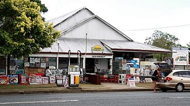
Calen general store, 2009
|
|||||||||||||||
| Population | 427 (2021 census) | ||||||||||||||
| • Density | 5.939/km2 (15.38/sq mi) | ||||||||||||||
| Postcode(s) | 4798 | ||||||||||||||
| Area | 71.9 km2 (27.8 sq mi) | ||||||||||||||
| Time zone | AEST (UTC+10:00) | ||||||||||||||
| Location |
|
||||||||||||||
| LGA(s) | Mackay Region | ||||||||||||||
| State electorate(s) | Whitsunday | ||||||||||||||
| Federal Division(s) | Dawson | ||||||||||||||
|
|||||||||||||||
Calen is a small town in the Mackay Region, Queensland, Australia. It's a rural area, meaning it's mostly countryside, and it's also near the coast. In 2021, about 427 people lived in the Calen area.
Contents
What is Calen Like?
Calen's Location and Landscape

The Calen area is mostly flat land. This flat land is perfect for growing sugar cane, which is a very important crop here. To the west, there are some undeveloped mountains. On the eastern side, you'll find small hills near the Queensland coast.
Two main roads and a railway line pass through Calen. The Bruce Highway goes from the south-east to the north-west. The North Coast railway line runs right next to the highway.
Towns and Neighbourhoods in Calen
The main town of Calen is in the south-eastern part of the area. Both the highway and the railway go through it. You can find the Calen railway station right in the town.
Another small town called Kolijo is very close by, just 1.5 kilometres away. It's also on the highway and railway line. A creek called St Helens Creek separates Calen and Kolijo.
At the north-western edge of the Calen area, there's a neighbourhood called Moondaba. It's also along the highway and railway. Moondaba means place of snakes in an Aboriginal language. It's very close to another town called Pindi Pindi.
Around Calen, you'll see special tramway lines. These are private lines used to transport sugar cane to the sugar mill.
Calen's History
How Calen Got Its Name
The town of Kolijo got its name from the Kolijo railway station. This name was chosen in 1923. It's an Aboriginal word that means possum.
The town of Calen was named after its railway station in 1924. The name Calen is also an Aboriginal word, and it means cloud.
Schools and Churches
Calen State School first opened its doors on February 24, 1925. At first, it was just a primary school. In 1963, it started offering secondary schooling up to Year 10. Then, in 1991, it expanded again to include Years 11 and 12. In 2003, its name changed to Calen District State College.
A church called William Pratt Memorial Church opened in 1930. It was a church for both Presbyterian and Methodist people. Today, it's known as Calen Uniting Church. William Pratt was an important sugar cane farmer in the area.
Calen also got its own Post Office around 1933.
Who Lives in Calen?
The number of people living in Calen changes over time. A census is like a big count of everyone in an area.
- In 2006, about 289 people lived in Calen.
- By 2011, the population grew to 451 people.
- In 2016, it was 390 people.
- The most recent count in 2021 showed 427 people living in the Calen area.
Learning in Calen
Calen District State College is the main school in the area. It's a government school for both boys and girls. Students can attend from Prep (the year before Year 1) all the way up to Year 12. In 2018, the school had 195 students and many teachers and staff. It also has a special program for students who need extra support.
Places to Visit and Use
Community Services
The Mackay Regional Council provides a mobile library service. This means a library on wheels visits Calen every two weeks. It stops on McIntyre Street, near the school.
Churches and Community Halls
- St Helen's Catholic Church is located on McIntyre Street.
- Calen Uniting Church is also on McIntyre Street. It's sometimes called the William Pratt Memorial Calen Community Church. As of 2020, this church was closed.
- The Queensland Country Women's Association (QCWA) has a hall on McIntyre Street. This is where local women meet for community activities.
Important Facilities
Calen has several important facilities to help the community:
- The Calen Police Station is on the Bruce Highway.
- The Calen Ambulance Station is on McIntyre Street.
- The Calen SES Facility is on Pratts Road. The SES helps people during emergencies like floods or storms.
 | Toni Morrison |
 | Barack Obama |
 | Martin Luther King Jr. |
 | Ralph Bunche |


