California Hill facts for kids
Quick facts for kids |
|
|
California Hill
|
|

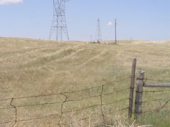
California Hill, rising from the South Platte River Valley to the crest to reach the North Platte River on the California and Oregon Trails.
|
|
| Nearest city | Brule, Nebraska |
|---|---|
| Area | 140 acres (57 ha) |
| Built | 1847 |
| NRHP reference No. | 74001126 |
| Added to NRHP | July 15, 1974 |
California Hill is a famous hill in Nebraska. It was the very first big hill that pioneers had to climb when they traveled west on the Oregon Trail and California Trail. Imagine being one of those early travelers, seeing this hill as your first major challenge!
Contents
What is California Hill?
California Hill is a significant landmark for anyone interested in American history. It's not the steepest hill, but it was the first major climb for thousands of people heading to new lands. The hill is located in western Nebraska. It rises from the valley of the South Platte River. After climbing it, travelers reached a flat area that led to the North Platte River.
The Journey West
Pioneers traveling west faced many challenges. One of the biggest was deciding where to cross the South Platte River. This river was a major obstacle. After crossing it, they would then head towards the North Platte River. The North Platte River was the preferred route. It led them towards important places like Fort Laramie in Wyoming.
Crossing the South Platte River
Many different spots were used to cross the South Platte River. The most popular crossing was called the California Crossing. It was about 53 miles (85 km) west of a place called O'Fallon's Bluffs. This crossing was the most direct way to get to Ash Hollow and the North Platte River.
Even though the South Platte River looked shallow, it was very tricky. Its bottom was sandy, which made it a huge problem for heavy wagons. The sand could act like quicksand, trapping wagons. The moving water also made it hard to cross safely. Many wagons got stuck or even tipped over. This was especially true in May and early June. During these months, melting snow from the mountains made the river very full and fast.
Climbing California Hill
Once the pioneers successfully crossed the South Platte River, they faced California Hill. This climb was about 240 feet (73 meters) high. It stretched for about 1.5 miles (2.4 km). After this climb, they reached a flat plateau. This plateau stretched between the two branches of the Platte rivers. While there were much steeper hills later on the trail, California Hill was the first big one. It was a true test for the pioneers and their wagons.
California Hill Today
The South Platte River looks different today than it did during the pioneer era. More bushes and plants have grown along its banks. Also, much of the river's water is now used to irrigate nearby farms.
You can still see parts of the old wagon trail today. The ruts left by thousands of wagons are visible for almost 0.75 miles (1.2 km) to the southeast. These ruts reach U.S. Highway 30. You can also see them for about 0.5 miles (0.8 km) to the northwest. There, they disappear into the farmed fields on the plateau. The ruts leading up from U.S. 30 look like gentle dips in the ground, covered by plants. To the northwest, the ruts appear as clear cuts in the hillside. They are a reminder of the incredible journey pioneers made long ago.
 | James B. Knighten |
 | Azellia White |
 | Willa Brown |


