
California Historical Landmarks in Shasta County facts for kids
California's Shasta County is full of amazing places that tell stories from a long time ago! These special spots are called California Historical Landmarks. They help us remember important events, people, and places that shaped California's past. From old battle sites to pioneer homes and important roads, these landmarks are like open-air museums, showing us what life was like for the people who lived here centuries ago. Let's explore some of these cool historical places in Shasta County!
Contents
- Exploring Shasta County's History
- Important Places and Events
- Bass Hill: A Gold Rush Stop
- Battle Rock: A Historic Clash
- Bell's Bridge: Crossing Clear Creek
- Clear Creek: A Natural Landmark
- Dersch Homestead: Pioneer Life
- Fort Crook: Frontier Outpost
- Fort Reading: Another Important Fort
- Foundation of Catholic Basilica: A Spiritual Site
- French Gulch: A Gold Rush Town
- Lockhart Ferry: Crossing the River
- Pioneer Baby's Grave: A Sad Reminder
- Reading Adobe: An Early Home
- Reading's Bar: Gold Mining Spot
- Site of First School in Fall River Valley: Learning Begins
- Southern Hotel & Stage Station: A Traveler's Rest
- Whiskeytown: A Lively Camp
- Old Roads and Trails
- Early Settlements
- Important Places and Events
- Images for kids
Exploring Shasta County's History
Important Places and Events
Bass Hill: A Gold Rush Stop
Bass Hill (Landmark 148) is located near Castle Crags State Park. This spot was important during the California Gold Rush. Many miners and travelers passed through here on their way to find gold. It was a busy place where people would stop to rest and get supplies.
Battle Rock: A Historic Clash

Battle Rock (Landmark 116) is also found in Castle Crags State Park, near Castella. This site marks the location of the Battle of Castle Crags. This battle was a significant event between Native American tribes and early settlers in the area. It reminds us of the conflicts that happened as California grew.
Bell's Bridge: Crossing Clear Creek
Bell's Bridge (Landmark 519) was an important crossing point over Clear Creek. It was located near Highway 99 and Clear Creek Road in Redding. Bridges like this were vital for travel and trade in early California, connecting different communities.
Clear Creek: A Natural Landmark
Clear Creek (Landmark 78) itself is a historical landmark, located near Old Highway 99 and Canyon Road in Redding. This creek was a key waterway for Native Americans and later for miners and settlers. It played a big role in the development of the region.
Dersch Homestead: Pioneer Life
The Dersch Homestead (Landmark 120) is found on Dersch Road at Bear Creek, near Anderson. This homestead represents the homes and farms of early pioneers who settled in Shasta County. It shows us how families lived and worked the land in the past.
Fort Crook: Frontier Outpost

Fort Crook (Landmark 355) was an important military fort located near McArthur Road and Soldier Mountain Drive in Glenburn. Built in the mid-1800s, it helped protect settlers and travelers in the northern part of California. Soldiers stationed here played a role in keeping peace and order on the frontier.
Fort Reading: Another Important Fort
Fort Reading (Landmark 379) was another military post, situated at Deschutes and Dersch Roads near Anderson. Like Fort Crook, it was established to protect early American settlers and control routes through the region. These forts were crucial for the growth of California.
Foundation of Catholic Basilica: A Spiritual Site
The Foundation of Catholic Basilica (Landmark 483) is located at Red Bluff Road and Crocker Alley in Shasta. This site marks where an important religious building was planned or started. It shows the early presence of religious communities in the area.
French Gulch: A Gold Rush Town
French Gulch (Landmark 166) is a historic district and a town in French Gulch. This town was a bustling mining community during the Gold Rush. Many people came here hoping to strike it rich. Its historic buildings and layout still show what a lively gold mining town looked like.
Lockhart Ferry: Crossing the River

Lockhart Ferry (Landmark 555) was an important ferry crossing on State Highway 299 near Fall River Mills. Before bridges were common, ferries like this were the main way to cross rivers, helping people and goods move across the landscape.
Pioneer Baby's Grave: A Sad Reminder
The Pioneer baby's grave (Landmark 377) is a touching landmark on State Highway 299 near Shasta. It reminds us of the hardships and challenges faced by pioneer families, including the loss of loved ones during their difficult journeys and new lives.
Reading Adobe: An Early Home
The Reading Adobe (Landmark 10) is located at Reading Island Park, 213 Adobe Road, in Cottonwood. An adobe is a type of building made from sun-dried earth bricks. This adobe was an early home in the area, showing the building styles of the time.
Reading's Bar: Gold Mining Spot
Reading's Bar (Landmark 32) is found near the Clear Creek Bridge in Redding. This was a significant gold mining site during the Gold Rush. Many miners came here to search for gold along the creek.
Site of First School in Fall River Valley: Learning Begins

The Site of first school in Fall River Valley (Landmark 759) is on State Highway 299 near McArthur. This spot marks where the very first school in the Fall River Valley was built. It shows how important education was to early settlers, even in remote areas.
Southern Hotel & Stage Station: A Traveler's Rest
The Southern Hotel & Stage Station (Landmark 33) was located on old Highway 99, southwest of the Sims exit, near Castella. This was a vital stop for stagecoaches and travelers. It provided food, lodging, and a place to rest for people making long journeys across California.
Whiskeytown: A Lively Camp
Whiskeytown (Landmark 131) is located at Whiskey Creek Road and State Highway 299 in Whiskeytown. This was a lively mining camp during the Gold Rush. It was a busy place with miners, businesses, and all the excitement of a boomtown.
Old Roads and Trails
Noble Pass Route: A Pioneer Trail
The Noble Pass Route (Landmark 11) is part of the California Trail and is found in Lassen Volcanic National Park. This route was a path used by pioneers traveling to California. It was a challenging journey, and this trail helped many reach their new homes.
Old California-Oregon Road: A Major Route
The Old California-Oregon Road (Landmark 58) is located at the northwest corner of Highway 99 and Spring Gulch Road near Anderson. This road was a major route connecting California with Oregon. It was used by settlers, traders, and travelers moving between the two territories.
Early Settlements
Old Town of Shasta: A Ghost Town's Story
The Old town of Shasta (Landmark 77) is now part of Shasta State Historic Park in Shasta. This was once a very important and busy town during the Gold Rush. Today, it's a "ghost town" with preserved buildings that show what life was like in a thriving 19th-century California town. It's also listed on the National Register of Historic Places.
Images for kids
-
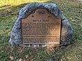
The plaque at Battle Rock, marking its historical significance.
-
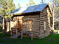
A cabin at Fort Crook, showing what the fort might have looked like.
-
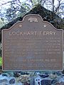
A historical marker for Lockhart Ferry.
-
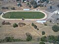
The football field of Fall River Junior-Senior High School, near the site of the first school.
