Campbells Creek (West Virginia) facts for kids
Quick facts for kids Campbells Creek |
|
|---|---|

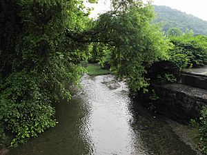
Campbells Creek near Coal Fork
|
|

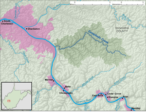
A map of Campbells Creek and its watershed
|
|
| Country | United States |
| State | West Virginia |
| County | Kanawha |
| Physical characteristics | |
| Main source | near Putney 1,430 ft (440 m) 38°17′47″N 81°21′52″W / 38.2964914°N 81.3645597°W |
| River mouth | Kanawha River near Port Amherst 568 ft (173 m) 38°19′00″N 81°33′46″W / 38.3167660°N 81.5628989°W |
| Length | 18.5 mi (29.8 km) |
| Basin features | |
| Basin size | 39.3 sq mi (102 km2) |
| Hydrologic Unit Code | 050500060404 (USGS) |
Campbells Creek is a stream in West Virginia, United States. It is about 18.5 miles (29.8 kilometers) long. This creek flows into the Kanawha River. It is part of a larger watershed that eventually leads to the Mississippi River.
About Campbells Creek
Campbells Creek is a tributary, which means it's a smaller stream that flows into a larger river. It helps drain water from an area of about 39.3 square miles (101.8 square kilometers). This area is part of the Allegheny Plateau, a high, flat landform. The creek is located within the Charleston metropolitan area.
Where Does Campbells Creek Flow?
Campbells Creek flows entirely within Kanawha County. It starts near a community called Putney. From there, it flows mostly northwest.
The creek passes through several small communities, including:
After passing these places, the creek turns southwest. It then flows through Tad and Coal Fork. Finally, Campbells Creek joins the Kanawha River near Port Amherst. You can often find county roads running alongside the creek for much of its journey.
Other Names for the Creek
Over time, Campbells Creek has been known by a few different names. The Geographic Names Information System lists some of these historical names. They include "Campbell Creek," "Campbell's Creek," and "Nip-pi-pin-mah."
 | John T. Biggers |
 | Thomas Blackshear |
 | Mark Bradford |
 | Beverly Buchanan |

