Camptonville, California facts for kids
Quick facts for kids
Camptonville, California
|
|
|---|---|

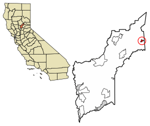
Location of Camptonville in Yuba County, California.
|
|
| Country | |
| State | |
| County | Yuba County |
| Area | |
| • Total | 0.86 sq mi (2.22 km2) |
| • Land | 0.86 sq mi (2.22 km2) |
| • Water | 0.00 sq mi (0.00 km2) 0% |
| Elevation | 2,825 ft (861 m) |
| Population
(2020)
|
|
| • Total | 158 |
| • Density | 184.15/sq mi (71.13/km2) |
| Time zone | UTC-8 (Pacific (PST)) |
| • Summer (DST) | UTC-7 (PDT) |
| GNIS feature IDs | 1658208; 2628715 |
Camptonville is a small town in Yuba County, California. It was once called Comptonville or Gold Ridge. This town is about 36 miles (58 km) northeast of Marysville. It sits on a ridge between two parts of the Yuba River. Camptonville is 2,825 feet (861 meters) above sea level. In 2020, about 158 people lived there.
Contents
History of Camptonville
Gold Rush Days
Gold was found in this area in 1850. Because of this, the place was first known as Gold Ridge. In 1854, the town got its first post office. Its name was changed to Camptonville. This new name honored Robert Campton, who was the town's blacksmith.
Camptonville was a very important place during the California Gold Rush. It was a popular stop for people traveling and moving goods. They used the Henness Pass Road. This road was a main path over the Sierra Nevada mountains in the 1850s and 1860s. A sign in Camptonville says the town was very busy. It had more than fifty saloons and even a bowling alley at one time.
Changes Over Time
After the gold mining slowed down, the town's main business became cutting timber. This means they used trees to make wood products. In 1994, a big timber company called Sierra Mountain Mills closed. This caused 75 people to lose their jobs. Many people then moved away from Camptonville.
Today, Camptonville is still a small town. It has a gas station and a convenience store called Lost Nugget. There is also a post office and the Camptonville Elementary School. You can find a special monument there. It honors the Pelton wheel, which is a type of water wheel. The person who invented it lived in Camptonville in the 1860s. The original Mayo Saloon is still there too. It is now a restaurant and bar. The town also has an office for the Tahoe National Forest. This office is home to the Tahoe Hotshots, a special firefighting team.
Geography
Camptonville is a small area covering about 0.9 square miles (2.3 square kilometers). All of this area is land.
Climate
Camptonville has a type of weather called a warm-summer Mediterranean climate. This means it has hot, dry summers and mild, wet winters.
Population Information
| Historical population | |||
|---|---|---|---|
| Census | Pop. | %± | |
| 2020 | 158 | — | |
| U.S. Decennial Census 1850–1870 1880-1890 1900 1910 1920 1930 1940 1950 1960 1970 1980 1990 2000 2010 |
|||
In 2010, the town of Camptonville had 158 people. Most of the people living there were White. There were also Native American, Asian, and people of two or more races. A small number of people were Hispanic or Latino.
All 158 people lived in homes. There were 70 homes in total. About 31% of these homes had children under 18 living in them. The average home had about 2.26 people. The average age of people in Camptonville was about 44 years old.
See also
 In Spanish: Camptonville para niños
 | Kyle Baker |
 | Joseph Yoakum |
 | Laura Wheeler Waring |
 | Henry Ossawa Tanner |


