Canaan, New York facts for kids
Quick facts for kids
Canaan, New York
|
|
|---|---|
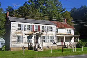
The Lace House in Canaan
|
|
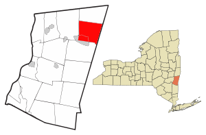
Location of Canaan, New York
|
|
| Country | United States |
| State | New York |
| County | Columbia |
| Government | |
| • Type | Town council |
| Area | |
| • Total | 36.93 sq mi (95.65 km2) |
| • Land | 36.65 sq mi (94.93 km2) |
| • Water | 0.28 sq mi (0.72 km2) |
| Elevation | 981 ft (299 m) |
| Population
(2020)
|
|
| • Total | 1,570 |
| • Density | 42.51/sq mi (16.41/km2) |
| Time zone | UTC-5 (Eastern (EST)) |
| • Summer (DST) | UTC-4 (EDT) |
| ZIP code |
12029
|
| Area code(s) | 518 |
| FIPS code | 36-021-12056 |
| GNIS feature ID | 0978781 |
Canaan is a small town located in Columbia County, New York. It's a quiet place in the northeastern part of the county. In 2020, about 1,570 people lived here. This was a bit less than the 1,710 people counted in 2010.
Contents
A Look Back: History of Canaan
The first people to settle in Canaan arrived around 1759. The town was officially started in 1772. Back then, it was called "Kings District." The name was changed to "Canaan" in 1788.
One of the oldest parts of Canaan is Frisbie Street. It was settled in 1770 by Gideon Frisbie, who came from Canaan, Connecticut. Frisbie Street was once part of an important stagecoach route. This route connected the cities of Albany and Boston.
The 1973 Tornado Event
On August 28, 1973, a very strong tornado hit Canaan. It then moved into Massachusetts. This tornado caused a lot of damage to buildings and properties. It also affected many people. After the tornado passed, there was about $25 million in damage. This would be around $148 million today.
Historic Buildings
The Lace House is a special building in Canaan. It was added to the National Register of Historic Places in 1985. This means it's recognized as an important historic site.
Where is Canaan? Geography
Canaan covers about 95.7 square kilometers (36.9 square miles). Most of this area is land, about 95.0 square kilometers (36.65 square miles). A small part, about 0.7 square kilometers (0.28 square miles), is water.
Most of the water in Canaan flows west or north. It goes into streams like Queechy Lake Brook and Buttercup Creek. These streams eventually join the Hudson River. The very southeastern part of town drains into the Housatonic River.
The eastern edge of Canaan is also the border with the state of Massachusetts.
Roads and Mountains
Interstate 90 is a major highway that goes through Canaan. It connects the Massachusetts Turnpike to the east with the New York State Thruway to the west. There is one exit for I-90 in Canaan, which connects to New York State Route 22.
The Taconic Mountains are a mountain range that you can see in the northeastern part of the town.
Who Lives in Canaan? Demographics
| Historical population | |||
|---|---|---|---|
| Census | Pop. | %± | |
| 1820 | 2,079 | — | |
| 1830 | 2,064 | −0.7% | |
| 1840 | 1,957 | −5.2% | |
| 1850 | 1,941 | −0.8% | |
| 1860 | 2,197 | 13.2% | |
| 1870 | 1,877 | −14.6% | |
| 1880 | 1,654 | −11.9% | |
| 1890 | 1,561 | −5.6% | |
| 1900 | 1,307 | −16.3% | |
| 1910 | 1,167 | −10.7% | |
| 1920 | 1,085 | −7.0% | |
| 1930 | 979 | −9.8% | |
| 1940 | 1,042 | 6.4% | |
| 1950 | 1,284 | 23.2% | |
| 1960 | 1,272 | −0.9% | |
| 1970 | 1,472 | 15.7% | |
| 1980 | 1,654 | 12.4% | |
| 1990 | 1,773 | 7.2% | |
| 2000 | 1,820 | 2.7% | |
| 2010 | 1,710 | −6.0% | |
| 2020 | 1,570 | −8.2% | |
| U.S. Decennial Census 2020 | |||
In 2000, there were 1,820 people living in Canaan. There were 643 households, which are groups of people living together. About 27% of these households had children under 18 living with them.
The average age of people in Canaan in 2000 was 38 years old. About 34% of the population was under 18.
Places and Communities in Canaan
Canaan has several small communities and interesting spots:
- Canaan – This is the main village in the north-central part of town. It used to be called "Canaan Corners."
- Canaan Center – A small community located south of Canaan village.
- East Chatham – A community found at the western edge of the town.
- Edwards Park – A specific location southeast of Flatbrook.
- Flatbrook – Another community located southeast of Canaan village, along Route 22.
- Queechy – A community located east of Canaan village.
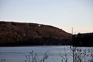
- Queechy Lake – This is a 600-acre lake near the eastern border of the town. It was once known as Whiting's Pond.
- Red Rock – A community found at the southern border of the town.
Famous People from Canaan
Many interesting people have connections to Canaan:
- Phoebe Hinsdale Brown (1783–1861) – She was the first American woman to write a very popular hymn, "I love to steal awhile away."
- Asa Adgate (1767–1832) – Born in Canaan, he became a U.S. congressman.
- Daniel G. Garnsey – Another U.S. congressman.
- Anne Meacham (1925-2006) – A well-known American actress.
- Eleazer Root (1802–1887) – Born in Canaan, he was an educator and an Episcopal priest.
- Al Roker (born 1954) – A famous television personality and weather forecaster. He owns a summer home in Canaan.
- Henry L. Warner – A farmer who was a member of the New York State Assembly in 1892.
See also
 In Spanish: Canaan (Nueva York) para niños
 | Shirley Ann Jackson |
 | Garett Morgan |
 | J. Ernest Wilkins Jr. |
 | Elijah McCoy |


