Canisteo (village), New York facts for kids
Quick facts for kids
Canisteo, New York
|
|
|---|---|
|
Village
|
|

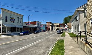
Greenwood Street, looking north towards East Main Street, June 2021
|
|
| Country | United States |
| State | New York |
| County | Steuben |
| Area | |
| • Total | 0.93 sq mi (2.42 km2) |
| • Land | 0.93 sq mi (2.42 km2) |
| • Water | 0.00 sq mi (0.00 km2) |
| Elevation | 1,135 ft (346 m) |
| Population
(2020)
|
|
| • Total | 2,176 |
| • Density | 2,329.76/sq mi (899.84/km2) |
| Time zone | UTC-5 (Eastern (EST)) |
| • Summer (DST) | UTC-4 (EDT) |
| ZIP code |
14823
|
| Area code(s) | 607 |
| FIPS code | 36-12254 |
| GNIS feature ID | 0945774 |
Canisteo is a small village located in Steuben County, New York, United States. In 2020, about 2,176 people lived there.
The Village of Canisteo is in the northwest part of the Town of Canisteo. It is located southeast of the city of Hornell.
Contents
History
Early Settlements
Canisteo was a community even before European settlers arrived. It was in a quiet area between the lands of the Seneca and Delaware Indians. Some old stories mention a "Kanestio castle." This wasn't a stone castle, but likely a permanent village.
One historian, Harlo Hakes, wrote in 1896 that the area was a favorite hunting and fishing spot for Native Americans. The village of 'Kanestio' was home to some Delaware Indians. It also had some people who had left British settlements. This village was destroyed in 1765 after conflicts arose.
European Settlers Arrive
The First Village
The first written mention of a settlement in what is now Steuben County was about "Kanestio Castle." It was described as having many houses built of timber, each with stone chimneys. This suggests European building styles. Some early accounts say it was a community of people from different backgrounds.
In 1762, conflicts happened involving people from Kanestio. In response, Sir William Johnson sent a group of British troops and Native Americans in 1764. They burned about 60 houses and destroyed crops. This ended the settlement at Kanestio Castle.
New Beginnings
New settlers started arriving around 1789. This made Canisteo one of the first settlements in Steuben County. Travel and trade mostly happened through Pennsylvania, following the Canisteo River. There were no direct routes to Albany or New York City at first.
The village grew a lot after the Erie Railroad arrived in 1851. This railroad connected Canisteo to New York City. Many factories opened, and the village officially became a village in 1873.
Before it was incorporated, the village was called Bennettsville. The original Canisteo was actually southeast of the current village. When the Erie Railroad was built, the train station was placed further upriver. A new community grew around this station, which became the center of Canisteo.
The Railroad Era
In the 1800s and early 1900s, Railroad Street (now Greenwood Street) was the main street in Canisteo. Before 1851, people traveled by the Canisteo River. The Erie Railroad changed this, making the railroad the main way to travel.
In 1892, a trolley line, the Hornellsville & Canisteo Railway, connected Canisteo with Hornell. This trolley linked the Erie station to the center of Canisteo. Later, in 1912, a new hard-surface road was built between Hornell and Canisteo. This road later became New York Route 36. As cars became popular, this road replaced the railroad for travel. All Erie train service to Canisteo ended in the 1940s.
Canisteo had many businesses during this time. The first factory, L. Allison's boot and shoe factory, started in 1868. By 1873, Canisteo had doctors, a dentist, lawyers, stores, and small factories making shoes, beehives, and flour. The Canisteo Steam Power Company made steam engines.
By 1878, the value of goods made in Canisteo reached a million dollars. Factories made items like buttons, rulers, dresses, and car springs. In 1888, Canisteo was described as a successful and busy place.
In 1892, 20 street lights were installed, making the village brighter. A business guide from 1893 said Canisteo had a bank, a newspaper, churches, a fire department, and hotels. It also had factories making doors, shoes, leather, and washing machines.
20th Century Changes
Canisteo got telephone service around 1902. Dial service came around 1950. For a long time, it was hard to call Hornell directly.
In the 1950s, the central park, called The Green, was removed to create more parking for downtown shops.
Businesses and Industries
In the 1800s, Canisteo had many small factories, with 10 operating in 1873. These included the Voorhis planing mill and the Canisteo Sash & Door Company. The Henry Carter and Son foundry, started in 1873, made steam engines and metal products.
The Tucker button factory was also on Depot Street. Later, the Thomas Spring & Gear Company used this factory to make shock absorbers for Ford cars.
Other businesses included the Canisteo Silk Mill, which had 200 employees in the 1920s. There was also a sawmill and Scott's Dairy, which processed milk and had an ice cream shop.
The New York & Pennsylvania Railroad had its offices and repair shop in Canisteo from 1894 to 1935. The Canisteo Theater, a brick building, closed in the 1950s.
Today, the main industry in Canisteo is the Welles Bros. sign factory. It started in 1955 and moved to its current building in 1967.
Newspapers
Canisteo has had several newspapers over the years:
- The Canisteo Reporter was published in 1873.
- The Canisteo Citizen was published from 1874 to 1875.
- The Canisteo Times was published from 1875 to 1889. It later became the Canisteo Weekly Times and focused on the temperance cause. It continued until 1957.
- The Canisteo Tidings moved to Canisteo in 1894 but did not last long.
- The Canisteo Chronicle started in 1900.
Schools
The Village of Canisteo is home to the Canisteo-Greenwood Elementary, Middle, and High Schools.
Transportation
The old Erie Railroad started operating in 1851. It passed east of Canisteo, offering passenger service until the 1940s. From 1892 to 1926, the Hornellsville and Canisteo Railway (a trolley line) connected Canisteo to Hornell. Bus service later replaced the trolley.
From 1896 to 1936, the New York & Pennsylvania Railroad ran south from Canisteo. Around 1900, the Erie Railroad had 10 passenger trains daily, and the trolley had 20.
Flood Control System
Canisteo was badly affected by a large flood in July 1935. To prevent future floods, two large walls called levees were built using government money. One levee protects the village from the Canisteo River. The other protects it from Bennett's Creek and Purdy Creek.
Bennett's Creek, which used to flow through the village, was rerouted. This created new land where Elm Street is now. New bridges for Route 36 and Route 248 were also built. The village's sewer system was part of this project too. The only major flood since then was during Hurricane Agnes in 1972.
Living Sign
Canisteo is famous for its "world famous living sign." This sign spells out the village's name using Scots Pine trees. It has been around for over fifty years and was even featured in a Ripley's "Believe it or Not!" book.
You can see the sign from Greenwood Street, near the elementary school. It is so well-aligned that the armed services sometimes use it to find true north when flying over. The Canisteo Living Sign was added to the National Register of Historic Places in 2004.
USS Canisteo
A US Navy ship, a fleet oil frigate (AO-99), was named USS Canisteo. It was used until the 1990s and helped during the Cuban missile crisis in the 1960s. Its motto was "If freedom were easy we wouldn't be here." See USS Canisteo (AO-99).
Steamer Canisteo
In the 1890s, a large boat called a steamer, named Canisteo, sailed on the Great Lakes.
Canisteo Peninsula, Antarctica
There is also an ice-covered area in Antarctica called the Canisteo Peninsula.
Geography
Canisteo is located at 42°16′12″N 77°36′23″W / 42.27000°N 77.60639°W.
The United States Census Bureau says the village covers about 1.0 square mile (2.5 square kilometers), all of it land.
The village is where New York State Route 36 and New York State Route 248 meet. The Canisteo River flows past the northern side of the village, where it meets Bennetts Creek.
Demographics
| Historical population | |||
|---|---|---|---|
| Census | Pop. | %± | |
| 1860 | 300 | — | |
| 1880 | 1,907 | — | |
| 1890 | 2,071 | 8.6% | |
| 1900 | 2,077 | 0.3% | |
| 1910 | 2,259 | 8.8% | |
| 1920 | 2,201 | −2.6% | |
| 1930 | 2,548 | 15.8% | |
| 1940 | 2,550 | 0.1% | |
| 1950 | 2,625 | 2.9% | |
| 1960 | 2,731 | 4.0% | |
| 1970 | 2,772 | 1.5% | |
| 1980 | 2,679 | −3.4% | |
| 1990 | 2,421 | −9.6% | |
| 2000 | 2,336 | −3.5% | |
| 2010 | 2,270 | −2.8% | |
| 2020 | 2,176 | −4.1% | |
| U.S. Decennial Census | |||
In 2000, there were 2,336 people living in Canisteo. There were 948 households and 626 families. The population density was about 2,415 people per square mile.
About 29.6% of households had children under 18. Most people were White (98.16%). The average household had 2.46 people.
The median age in the village was 39 years old. About 26.6% of the population was under 18.
The median income for a household was $32,269. For families, it was $42,560. About 10.6% of the population lived below the poverty line.
Sister Cities
Canisteo has a sister city, which means they have a special friendly relationship:
See also
 In Spanish: Canisteo (villa) para niños


