
Canta facts for kids
Quick facts for kids
Canta
|
|
|---|---|

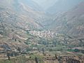
View of the town of Canta
|
|

Canta
Location in Peru
|
|
| Country | |
| Region | Lima |
| Province | Canta |
| District | Canta |
| Elevation | 2,819 m (9,249 ft) |
| Population
(2017)
|
|
| • Total | 2,385 |
| Demonym(s) | Canteño/a |
| Time zone | UTC−5 (PET) |
Canta is a charming town located in the Lima Region of western Peru. It sits right by the Chillón River. Canta is the main town, or capital, of the Canta Province.
In 2017, about 2,385 people lived in Canta. It's also the capital of the Canta District. Many tourists from Lima visit Canta. They come to enjoy its peaceful atmosphere and beautiful natural scenery. The town is quite high up, at 2,819 meters (about 9,249 feet) above sea level.
Contents
What Does the Name Canta Mean?
The word Canta comes from the ancient Cauqui language. This language was spoken by the people who lived here long ago. The name can have two main meanings:
- canta = a special rope used to catch vicuñas (animals similar to llamas)
- canta = a hillside or a slope
Where is Canta Located?
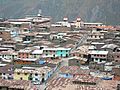
Canta is about 103 kilometers (64 miles) away from Lima. It takes about three hours to get there by bus. Students who study geography often visit Canta. The small town of Obrajillo is also very close by.
-
An aerial view of Canta, Peru
-
Another aerial view of Canta, Peru


What is Canta's Weather Like?
Canta has a dry subtropical highland climate. This means it's usually warm during the day and cooler at night. It's also known as a semi-arid climate, which means it doesn't get a lot of rain overall.
The temperatures in Canta stay pretty steady throughout the year. The average high temperature is around 18.0°C (64.4°F). The average low temperature is about 8.0°C (46.4°F).
Canta gets about 376.4 millimeters (14.82 inches) of rain each year. Most of this rain falls during the wet season. This rainy period usually lasts from January to March. From May to September, Canta typically gets very little rain.
| Climate data for Canta (1991–2020) | |||||||||||||
|---|---|---|---|---|---|---|---|---|---|---|---|---|---|
| Month | Jan | Feb | Mar | Apr | May | Jun | Jul | Aug | Sep | Oct | Nov | Dec | Year |
| Mean daily maximum °C (°F) | 17.2 (63.0) |
16.8 (62.2) |
16.9 (62.4) |
17.7 (63.9) |
18.5 (65.3) |
18.5 (65.3) |
18.5 (65.3) |
18.9 (66.0) |
18.9 (66.0) |
18.5 (65.3) |
18.1 (64.6) |
17.5 (63.5) |
18.0 (64.4) |
| Mean daily minimum °C (°F) | 8.1 (46.6) |
8.2 (46.8) |
8.3 (46.9) |
8.3 (46.9) |
7.9 (46.2) |
7.6 (45.7) |
7.5 (45.5) |
7.9 (46.2) |
8.1 (46.6) |
8.2 (46.8) |
8.0 (46.4) |
8.3 (46.9) |
8.0 (46.4) |
| Average precipitation mm (inches) | 71.1 (2.80) |
93.4 (3.68) |
96.8 (3.81) |
30.3 (1.19) |
2.2 (0.09) |
0.5 (0.02) |
0.0 (0.0) |
0.8 (0.03) |
3.7 (0.15) |
11.3 (0.44) |
18.3 (0.72) |
48.0 (1.89) |
376.4 (14.82) |
| Source: NOAA | |||||||||||||
A Look at Canta's Past
In the 1500s, Canta was taken over by a powerful Inca ruler named Pachacuti. He was expanding his empire towards the north. When the Spanish explorers arrived, they found Canta to be a successful and thriving place.
The town was later given to a Spanish leader, don Nicolás de Ribera. During the fight for Peru's freedom from Spain, the people of Canta strongly supported the cause. They played an important role in helping Peru gain its independence.
See also
 In Spanish: Canta para niños
