Cape Ann facts for kids
Quick facts for kids
Cape Ann
|
|
|---|---|
|
Region of Massachusetts
|
|

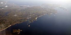
May 2008 aerial view of Cape Ann in Massachusetts. Gloucester and its harbor are visible to the upper right, and Manchester-by-the-Sea is at center, just west of Singing Beach.
|
|
| Etymology: Anne of Denmark | |
| Country | |
| State | |
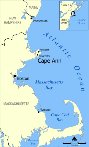
Cape Ann is a rocky piece of land that sticks out into the Atlantic Ocean. It's located in the northeastern part of Massachusetts. This area is about 30 miles (48 km) northeast of Boston. Cape Ann marks the northern edge of Massachusetts Bay.
The region includes the city of Gloucester. It also has the towns of Essex, Manchester-by-the-Sea, and Rockport.
Contents
Where Did Cape Ann Get Its Name?
In the summer of 1606, a French explorer named Samuel de Champlain visited Cape Ann. He landed in Gloucester and drew a map of its harbor. He called it le Beau port, which means "the beautiful harbor."
Eight years later, an English captain named John Smith explored the area. He first named the region around Gloucester Cape Tragabigzanda. This name was after a woman he met while he was a prisoner of war in Turkey.
Captain Smith showed his map to King Charles I. He suggested the king could change any "barbarous names" to English ones. King Charles I made many changes. Only four of his new names are still used today. One of these is Cape Ann. King Charles I named it to honor his mother, Anne of Denmark.
A Brief History of Cape Ann
Before Europeans arrived, Native American people lived on Cape Ann.
Early English Settlements
The first English colony on Cape Ann started in 1623. It was one of the first English settlements in New England. Two ships from the Dorchester Company brought 32 people. They came to set up a fishing business and a farm.
A legal government was formed at this Cape Ann settlement. This government later helped create the Massachusetts Bay Colony. Roger Conant was the governor under the Cape Ann agreement. Because of this, he is sometimes called the first governor of Massachusetts.
People who lived in this early colony were called "old planters." They built the first "Great House" in New England on Cape Ann. This large house was later moved to Salem in 1628. It became the governor's house there.
By 1634, the name Cape Ann was already well-known. It appeared on maps in a book called New England's Prospect.
Earthquake and Granite Industry
On November 18, 1755, Cape Ann was the center of an earthquake. Earthquakes are very rare in Massachusetts. There were no tools to measure earthquakes back then. But experts think it was about a 6.5 magnitude. It caused damage in Boston but no one was hurt.
By the mid-1800s, Cape Ann became famous for its granite production. Workers here made paving blocks for roads and streets. These granite blocks were used all over the United States. They went from New York to San Francisco.
Cape Ann as an Art Hub
In the 1800s, Cape Ann became a popular place for artists. The Rocky Neck Art Colony in Gloucester was one such place. Fitz Henry Lane started as a lithographer in Gloucester. He created a unique style of marine paintings called luminism.
The Cape Ann Museum has many paintings by local artists who became famous. Later, in the late 1800s and early 1900s, American Impressionist painters came to Rockport. One was Harry Aiken Vincent, who helped start the Rockport Art Association. Today, the area still has many art galleries and working artists.
Communities on Cape Ann
All of Cape Ann is located within Essex County. The main city is Gloucester. It is a center for the local fishing industry.
Other towns on Cape Ann include Rockport. Rockport is located at the very tip of the cape. The towns of Essex and Manchester-by-the-Sea are where Cape Ann connects to the mainland.
Geography of Cape Ann
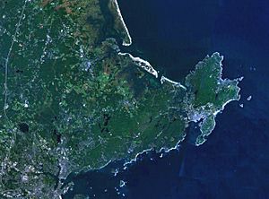
The Annisquam River runs through the end of Cape Ann. It divides Gloucester into two parts. Many people who live in Gloucester and Rockport call the land east of the Annisquam River "The Island."
Cape Ann in Popular Culture
Cape Ann is mentioned in many books, songs, and movies.
- The folk song 'Cape Ann' might have been written by Gordon Bok. It talks about a sailor's feelings about the area.
- The fictional town of Sea Harbor in the Seaside Knitters mysteries is on Cape Ann.
- The Harry Chapin song "Dogtown" is also about an abandoned town on the Cape.
- In the 1966 movie The Russians Are Coming the Russians Are Coming, "Gloucester Island" is off Cape Ann.
- The book Slaughterhouse Five mentions Cape Ann as a honeymoon spot.
- The movie The Perfect Storm was filmed in Gloucester in 2000. It tells the true story of a fishing boat from Gloucester.
- Cape Ann is the setting for the main character's home in the book Trouble.
- T. S. Eliot's poem "Landscapes" has a section called "Cape Ann." His poem The Dry Salvages also mentions rocks off Cape Ann.
- The fictional town of Paradise in the Jesse Stone novels is near Cape Ann.
See also
 In Spanish: Cabo Ann para niños


