
Cape Hatteras facts for kids
Quick facts for kids Cape Hatteras |
|
|---|---|
.jpg)
An aerial view of the Cape Hatteras Lighthouse prior to its 1999 relocation
|
|
| Location | Hatteras Island, Dare County, North Carolina, United States |
| Coordinates | 35°13′21″N 75°31′48″W / 35.22250°N 75.53000°W |
| Geology | Cape |

Cape Hatteras is a point of land that sticks out into the ocean. It's found on Hatteras Island, which is one of the barrier islands along the coast of North Carolina.
This area is a special kind of island that protects the mainland from ocean storms. It has been shaped by strong winds, big waves, and powerful storms. You can find long sandy beaches, tall sand dunes, marshy areas, and forests here. A big part of the Outer Banks is protected as a National Park. Cape Hatteras is also the closest land in North America to Bermuda, which is about 647 kilometers (402 miles) away to the east.
The waters off the Outer Banks are very dangerous for ships. They are even called the "Graveyard of the Atlantic" because over 600 ships have sunk here. This happened because of shallow sandbanks, bad storms, and wars. One very tricky spot is called Diamond Shoals, which is a hidden area of shifting sand ridges under the rough sea. For hundreds of years, many lives were lost here. But brave islanders, like those in the United States Life-Saving Service, helped rescue many people. Lighthouses were also built to guide sailors safely. Today, fewer ships wreck, but storms still uncover the remains of old shipwrecks on the beaches.
The Cape Hatteras National Seashore protects parts of three barrier islands: Bodie Island, Hatteras Island, and Ocracoke Island. Visitors can find beach access, campgrounds, nature trails, and lighthouses on all three islands.
The town of Buxton is located on the inside of Cape Hatteras, where Hatteras Island is widest. It's the biggest town on the island and has the main government offices and schools for the area.
Geography
Cape Hatteras is part of the Outer Banks, which are long, thin islands that curve out into the Atlantic Ocean. They then curve back towards the U.S. mainland, creating calm lagoons and estuaries (where rivers meet the sea) that are protected from the ocean. The dangerous sandbanks off the cape are known as Diamond Shoals.
Climate

Cape Hatteras has a warm, wet climate with long, hot summers and short, mild winters. Because it's surrounded by water (Pamlico Sound to the west and the Atlantic Ocean to the east), the temperatures stay more moderate throughout the year. This means summers are cooler and winters are warmer than in areas further inland in North Carolina.
In the summer, the average daily high temperatures are around 30-31°C (86-87°F). It can get very hot, but usually only for short periods. Temperatures above 32°C (90°F) are rare, happening only a few days a year. The coolest month is January, with average daily highs around 13°C (55°F) and lows usually above freezing, around 5°C (41°F). Freezing temperatures usually happen from mid-December to early March. The lowest temperature ever recorded was -14°C (6°F) in January 1985, and the highest was 36°C (97°F) in June 1952.
Snowfall is rare and usually very light. Cape Hatteras gets a lot of rain, over 155 centimeters (61 inches) per year, making it the wettest coastal spot in North Carolina. Rain is spread out throughout the year, but August to October are the wettest months. September is often the rainiest because of summer thunderstorms and tropical storms like hurricanes.
Because of its location, Cape Hatteras is one of the most likely places on the U.S. East Coast to be hit by hurricanes and tropical storms. These storms can cause a lot of wind and water damage. For example, Hurricane Isabel in 2003 caused a lot of damage. It even split Hatteras Island in two, creating a new inlet (a narrow passage of water). The main road, NC 12, was washed out, and students had to take a ferry to school. The Army Corps of Engineers filled in the inlet with sand, and the road and utilities were quickly rebuilt. More recently, Hurricane Dorian made landfall at Cape Hatteras on September 6, 2019.
History

The name Hatteras is one of the oldest English place-names still used in the U.S. An inlet north of the cape was first called "Hatrask" in 1585 by Sir Richard Grenville, who led an expedition for Sir Walter Raleigh. Later, the name was changed to "Hatteras" and used for the island and the cape. It comes from the name of the Hatteras Indians.
Sailors often travel close to Cape Hatteras to use the ocean currents to speed up their journeys. However, this means they risk the dangers of the shallow sandbanks, rough waters, and frequent storms. Because so many ships have been lost here, the area is known as the "Graveyard of the Atlantic". Cape Hatteras is also a very popular spot for surfing.
The first lighthouse at the cape was built in 1803. It was replaced by the current Cape Hatteras Lighthouse in 1870. This lighthouse is 60.5 meters (198.5 feet) tall, making it the tallest lighthouse in the United States and one of the tallest brick lighthouses in the world. In 1999, the ocean was getting too close to the lighthouse. So, the huge 4,830-ton lighthouse was carefully lifted and moved inland about 884 meters (2,900 feet). Now, it's about 457 meters (1,500 feet) from the seashore, which is similar to how far it was when it was first built.
Awards and recognition
Cape Hatteras has received some cool awards:
- One of the Top 10 U.S. Beaches by Travel Channel
- One of the Top 10 U.S. Beaches for 2016 by CNN
- One of America's Top 10 Beaches of 2015 by Forbes
Education
Students living in Cape Hatteras go to schools run by Dare County Schools. The local schools are Cape Hatteras Elementary School and Cape Hatteras Secondary School.
Images for kids
-
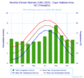
This chart shows typical weather patterns for Cape Hatteras.
_-_Cape_Hatteras_Area,NC_(ThreadEx).svg)
See also
 In Spanish: Cabo Hatteras para niños
