
Capellen facts for kids
Quick facts for kids
Capellen
Capellen
|
|
|---|---|

Capellen castle.
|
|
| Country | |
| Canton | Capellen |
| Commune | Mamer |
| Area | |
| • Total | 3.2 km2 (1.2 sq mi) |
| Highest elevation | 323 m (1,060 ft) |
| Population
(2015)
|
|
| • Total | 1,677 |
| • Density | 524/km2 (1,357/sq mi) |
| Time zone | UTC+1 (CET) |
| • Summer (DST) | UTC+2 (CEST) |
Capellen is a small town in the country of Luxembourg. It is located in the southwest part of the country. Capellen is part of the Mamer area, which is called a commune. It is about 12 kilometers (7.5 miles) west of Luxembourg City, the capital.
Even though there isn't a commune named Capellen, the larger area around it, called a canton, is named after the town.
Contents
History of Capellen
Capellen has a long history. It is built on an old Roman road. This road once connected Trier in Germany to Reims and Paris. Today, this old road is known as the Kiemwee.
In 1840, Luxembourg was divided into different regions called cantons. There was a disagreement between the towns of Mamer and Koerich. Because of this, it was decided that the canton would be named Capellen. The town of Capellen then became the main town, or capital, of this canton.
Geography of Capellen
Capellen covers an area of about 3.2 square kilometers (1.2 square miles). The highest point in the town is near the church. It is about 323 meters (1,060 feet) above sea level.
Population in Capellen
In 2015, there were 1,677 people living in the Capellen area. This means that about 524 people lived in each square kilometer. This number shows how many people live in a certain space.
More About Luxembourg
If you want to learn more about Luxembourg, you can check out these pages:
- Cantons of Luxembourg
- Communes of Luxembourg
- List of cities in Luxembourg
Images for kids
-
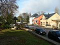
Capellen, Luxembourg: Road through the centre
-
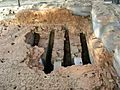
The Roman brick kiln in Capellen, Luxembourg


See also
 In Spanish: Capellen para niños
