
Mamer facts for kids
Quick facts for kids
Mamer
Mamer
|
||
|---|---|---|

|
||
|
||

Map showing, in orange, the Mamer commune
|
||
| Country | ||
| Canton | Capellen | |
| Commune | Mamer | |
| Area | ||
| • Total | 27.5 km2 (10.6 sq mi) | |
| Highest elevation | 353 m (1,158 ft) | |
| Lowest elevation | 263 m (863 ft) | |
| Population
(2016)
|
||
| • Total | 8,695 | |
| • Density | 316.2/km2 (818.9/sq mi) | |
| Time zone | UTC+1 (CET) | |
| • Summer (DST) | UTC+2 (CEST) | |
| LAU2 | LU00009009 | |
| Website | Official website: http://www.mamer.lu/ | |

Mamer is a small town and a type of local government area called a "commune" in southwestern Luxembourg. It is part of the Capellen canton. Mamer is located about 7 kilometers (4.3 miles) west of Luxembourg City.
Contents
A Look Back: Mamer's History
Mamer has a long and interesting history. Long ago, a tribe called the Treveri lived here for hundreds of years. They were a Celtic group.
Ancient Times: Celts and Romans
Around 54 BC, the Treveri were conquered by Julius Caesar and the Romans. In the early 1970s, a Celtic necropolis (an ancient burial ground) from the 1st century was found. It was located on the Juckelsboesch plateau, between Mamer and Kehlen.
During the time of the Roman Empire, which lasted until about 450 AD, the Romans built many roads in the area. One important road, called the Kiem, connected Trier to Reims and passed right through where Mamer is today. A small Roman settlement named Mambra was located by the Mamer river. This settlement was burned down by invaders around 276 AD.
Modern Roads and Railways
Later, in 1790, a new road was built. It linked Luxembourg City to Brussels and also went through Mamer. In 1859, a railway line to Brussels was opened, and Mamer even got its own train station.
Where is Mamer? Geography and Location
Mamer is located in the southwestern part of Luxembourg. It sits on the Mamer river, which flows into the Alzette river.
Size and Height of the Land
The entire Mamer commune covers an area of about 27.5 square kilometers (10.6 square miles). The land here ranges in height from 263 meters (863 feet) to 353 meters (1,158 feet) above sea level. The church in Mamer is at an altitude of 297 meters (974 feet). The highest point in the commune is a spot called Juckelbösch, which is 353 meters (1,158 feet) high.
Neighboring Towns
Mamer is surrounded by seven other communes in Luxembourg:
- To the north: Koerich and Kehlen
- To the east: Strassen
- To the southeast: Bertrange
- To the southwest: Dippach
- To the west: Garnich
- To the northwest: Steinfort
The communes of Strassen and Bertrange are part of the Luxembourg canton. All the other surrounding communes are part of the Capellen canton, just like Mamer.
 |
Steinfort | Koerich, Kehlen | |
|
| Garnich | Strassen | |||
| Dippach | Bertrange |
Who Lives in Mamer? Population Details
As of January 1, 2016, there were 8,695 people living in the Mamer commune. This means there were about 316 people living in each square kilometer.
Besides the main town of Mamer, the commune also includes two other towns: Capellen and Holzem.
Famous People from Mamer
Several notable people have come from Mamer:
- Nicolaus Mameranus (1500–1567): He was a soldier and historian who worked for Emperor Charles V.
- Nicolas Frantz (1889–1985): A famous cyclist who won the difficult Tour de France race in both 1927 and 1928.
- Josy Barthel (1927–1992): An amazing athlete who won a gold medal in the 1500-meter race at the 1952 Olympics in Helsinki.
Mamer's Partner Towns
Mamer has a special connection with one other town. It is "twinned" with:
 Dangé Saint-Romain, France
Gallery
-
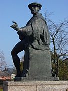
Statue of Nicolaus Mameranus
-
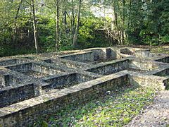
Ruins of the Gallo-Roman baths
-
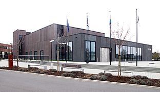
Cultural center Kinneksbond in Mamer


Related pages
Images for kids
-
Recently opened retirement home
-
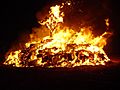
Bonfire for the winter buergbrennen festival celebrated in most Luxembourgish villages
-
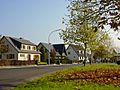
Domaine Mont Royal: typical of Mamer's residential areas
-
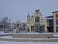
Mamer with a sprinkling of snow


