Capitol Heights, Maryland facts for kids
Quick facts for kids
Capitol Heights, Maryland
|
|||||
|---|---|---|---|---|---|

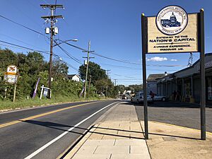
View east along Maryland State Route 332 (Central Avenue) at Southern Avenue in Capitol Heights
|
|||||
|
|||||

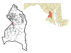
Location of Capitol Heights, Maryland
|
|||||
| Country | |||||
| State | |||||
| County | |||||
| Incorporated | 1910 | ||||
| Area | |||||
| • Total | 0.78 sq mi (2.02 km2) | ||||
| • Land | 0.78 sq mi (2.02 km2) | ||||
| • Water | 0.00 sq mi (0.00 km2) | ||||
| Elevation | 121 ft (37 m) | ||||
| Population
(2020)
|
|||||
| • Total | 4,050 | ||||
| • Density | 5,185.66/sq mi (2,002.72/km2) | ||||
| Time zone | UTC-5 (Eastern (EST)) | ||||
| • Summer (DST) | UTC-4 (EDT) | ||||
| ZIP codes |
20700-20799
|
||||
| Area code(s) | 301, 240 | ||||
| FIPS code | 24-13000 | ||||
| GNIS feature ID | 0597177 | ||||
Capitol Heights is a small town in Prince George's County, Maryland, United States. It is located right next to Washington, D.C.. In 2020, about 4,050 people lived there. The town has clear borders, including Southern Avenue and Eastern Avenue. The main zip code for Capitol Heights is 20743.
Contents
Where is Capitol Heights?
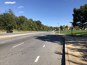
Capitol Heights is located at 38°52′55″N 76°54′52″W / 38.88194°N 76.91444°W. A major road called East Capitol Street (also known as MD 214) runs through the town. This road helps divide Washington, D.C., into its Northeast and Southeast parts.
Capitol Heights is an official town in Prince George's County. However, some nearby areas also use Capitol Heights addresses. These include places like Coral Hills and Walker Mill. The town itself covers about 0.80 square miles (2.02 square kilometers) of land.
Neighboring Areas
Capitol Heights is close to several other communities:
- Coral Hills (to the west and southwest)
- Seat Pleasant (to the northeast)
- Walker Mill (to the southeast)
A Look at Capitol Heights' History
In 1904, Washington, D.C., was growing very fast. Many people wanted to live outside the busy city. A man named Otway B. Zantzinger saw this as a chance to create a new community. He bought 400 acres of land near Washington, D.C. He then divided this land into 4,000 small lots to sell.
He advertised the area as a beautiful place with views of Washington, D.C. He also promised an electric railway for easy travel. People could buy land with low payments and no interest. However, at that time, there were rules about who could live in certain communities. This meant not everyone was allowed to buy land there.
Becoming a Town
Early residents had to walk about a mile to catch a train into Washington, D.C. This walk was often muddy because there were no paved roads or sidewalks. There were also no street lights or other public services.
Because of these issues, about 200 families decided to make their community official. In 1910, they voted to become the town of Capitol Heights. Over the next 50 years, the town worked hard to improve things. They built roads, sidewalks, and their own fire department. They also created a public works department. By the 1970s, the town had about 3,800 people.
Modern Times
In 1980, the long-awaited electric railway finally arrived. Capitol Heights got its own station on the Washington Metro Blue Line. This made it much easier for people to travel around the area. The land near the station is now a special "Enterprise Zone." This means the town is working to bring new businesses and jobs to the area. Today, most of the people living in Capitol Heights are African American. The town has also had four African-American mayors.
Past Mayors of Capitol Heights
Here are some of the people who have served as mayor:
- 1946-1950 Thomas A. Shaw
- 1950-1952 Harvey E. Ennis
- 1952-1954 Joseph Gainer
- 1954-1964 Elmer L. Hockman
- 1964-1986 Leo P. Forami
- 1986-2002 Vivian M. Dodson
- 2002-2006 Joyce Ayers Nixon
- 2006-2010 Darrell A. Miller
- 2010-2014 Kito James
- 2014-2018 Marnitta L. King
- 2018-2021 Shawn M. Maldon
Town Government
The town of Capitol Heights has a council that helps run things.
- The Mayor's office was temporarily empty until May 2022.
- Rhonda Akers, Councilwoman
- Caroline Brown, Councilwoman
- Renita A. Cason, Mayor Pro Tem, Councilwoman
- Latonya Chew, Councilwoman
- Faith Ford, Councilwoman
- Elaine Williams, Councilwoman
Who Lives in Capitol Heights?
| Historical population | |||
|---|---|---|---|
| Census | Pop. | %± | |
| 1920 | 1,194 | — | |
| 1930 | 1,611 | 34.9% | |
| 1940 | 2,036 | 26.4% | |
| 1950 | 2,729 | 34.0% | |
| 1960 | 3,138 | 15.0% | |
| 1970 | 3,835 | 22.2% | |
| 1980 | 3,271 | −14.7% | |
| 1990 | 3,633 | 11.1% | |
| 2000 | 4,138 | 13.9% | |
| 2010 | 4,337 | 4.8% | |
| 2020 | 4,050 | −6.6% | |
| U.S. Decennial Census 2010 2020 |
|||
Population in 2020
In 2020, the town had 4,050 people. Most residents were Black or African American (81.33%). About 13.19% of the population identified as Hispanic or Latino.
Population in 2010
In 2010, there were 4,337 people living in Capitol Heights. There were 1,482 households. The population density was about 5,421 people per square mile. Most people (91.3%) were African American. About 5.4% of the population was Hispanic or Latino.
Many households (42%) had children under 18. The average age in the town was 34.9 years. About 27.3% of residents were under 18 years old. More females lived in the town (54%) than males (46%).
Safety and Transportation
Law Enforcement
Capitol Heights has its own police department. Chief Darryl Morgan is the Chief of Police. The Prince George's County Police Department also helps serve the community.
Getting Around Capitol Heights
The main road in Capitol Heights is Maryland Route 214. This road goes west into Washington, D.C. It also goes east to connect with major highways like Interstate 95 and Interstate 495. Another road, Maryland Route 332, also runs through the town.
Community and Education
Community Groups
The Capitol Heights/Seat Pleasant chapter of the Prince George's County Boys and Girls Club helps young people. They offer after-school programs and sports. They also provide mentors for boys and girls.
There is also a conflict-mediation program in Capitol Heights. This program helps young people solve their differences peacefully.
Schools in Capitol Heights
Capitol Heights is part of the Prince George's County Public Schools system. Children in the town attend different schools based on where they live.
- Elementary schools include Capitol Heights, William Hall, and Doswell Brooks.
- Middle schools include William Hall and Walker Mill.
- High schools include Central High School and Suitland High School.
Famous People from Capitol Heights
- Chad Scott: An American football player who played for the Pittsburgh Steelers and the New England Patriots.
- James Tillman (1919–2009): A Negro league baseball player who lived in Capitol Heights for a long time.
See also
 In Spanish: Capitol Heights para niños
 | Laphonza Butler |
 | Daisy Bates |
 | Elizabeth Piper Ensley |


