Seat Pleasant, Maryland facts for kids
Quick facts for kids
Seat Pleasant, Maryland
|
|||
|---|---|---|---|
|
|||

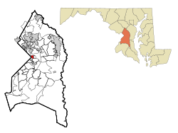
Location of Seat Pleasant, Maryland
|
|||
| Country | |||
| State | |||
| County | |||
| Incorporated | 1931 | ||
| Government | |||
| • Type | Nonpartisan | ||
| Area | |||
| • Total | 0.74 sq mi (1.92 km2) | ||
| • Land | 0.74 sq mi (1.92 km2) | ||
| • Water | 0.00 sq mi (0.00 km2) | ||
| Elevation | 108 ft (33 m) | ||
| Population
(2020)
|
|||
| • Total | 4,522 | ||
| • Density | 6,094.34/sq mi (2,352.59/km2) | ||
| Time zone | UTC-5 (Eastern (EST)) | ||
| • Summer (DST) | UTC-4 (EDT) | ||
| ZIP code |
20743
|
||
| Area code(s) | 301, 240 | ||
| FIPS code | 24-70850 | ||
| GNIS feature ID | 0598069 | ||
| Website | City of Seat Pleasant official website: http://www.seatpleasantmd.gov/ | ||
Seat Pleasant is a city in Prince George's County, Maryland. It is located just east of Washington D.C.. In 2020, about 4,522 people lived there.
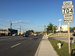
Two main roads, Maryland Route 704 (also called Martin Luther King Jr. Highway) and Maryland Route 214 (Central Avenue), go through the city. The Washington Metro train lines (Blue and Silver Lines) are also nearby. The Washington Commanders' football stadium is east of Seat Pleasant.
Contents
History of Seat Pleasant
Seat Pleasant is built on land that used to be part of a large estate. This estate belonged to the families of General Otho Holland Williams and James Berry. General Williams was a hero from the American Revolutionary War.
In 1850, Joseph Gregory bought some of this land. Seat Pleasant grew on his dairy farm and other family lands. In 1873, parts of the land were divided into smaller farms and home sites. This area was known as Jackson's Subdivision.
Early Transportation and Growth
The Chesapeake Beach Railway was built between 1897 and 1899. It connected Washington, D.C. to Chesapeake Beach, Maryland. The first train station in Maryland outside Washington was built on Joseph Gregory's property. It was first called "District Line."
A streetcar system also reached Seat Pleasant. It ended near what is now Martin Luther King Jr. Highway. Later, the Washington, Baltimore and Annapolis Electric Railway also passed through the area in 1908.
In 1906, the people living near the station chose a new name for their community. They called it Seat Pleasant, after the old Williams-Berry estate. Before that, the area was known as Chesapeake Junction.
Developing into a Railroad Suburb
As train traffic grew, Seat Pleasant became a "railroad suburb." This means it grew because people could easily travel by train. New neighborhoods were created, like Seat Pleasant Heights and Oakmont.
By 1915, the community had two churches and a fire department. Street lights were added in 1918. In 1931, Seat Pleasant officially became a town. It had a school, water, sewer systems, and good fire protection.
The Chesapeake Beach Railway stopped running in 1935. In the 1980s, the old train repair buildings were removed. This made space for the Addison Plaza Shopping Center.
Modern Development and Changes
After World War II, new highways helped Seat Pleasant grow more. In 1949, new "affordable" apartments were built. This led to many African-American families moving from Washington D.C. Before this, the community was mostly white.
The old path of the Washington, Baltimore and Annapolis Electric Railway became the George Palmer Highway. This road was later renamed the Martin Luther King Jr. Highway. The Addison Road Metro station opened in 1980.
Most of the old buildings from the town's past are gone. However, two churches remain: the Episcopal Addison Chapel (built in 1809) and Mount Victory Baptist Church (built in 1908).
Schools in Seat Pleasant
Students in Seat Pleasant attend schools in the Prince George's County Public Schools district.
Elementary Schools
The elementary schools that serve the city include:
- Seat Pleasant Elementary
- Carmody Hills Elementary
- Highland Park Elementary
Middle and High Schools
All students in Seat Pleasant attend G. James Gholson Middle School. For high school, students go to either Fairmont Heights High School or Central High School.
Geography of Seat Pleasant
Seat Pleasant is located at 38°53′43″N 76°54′8″W / 38.89528°N 76.90222°W.
The city covers a total area of about 0.73 square miles (1.9 square kilometers). All of this area is land.
Population Information
| Historical population | |||
|---|---|---|---|
| Census | Pop. | %± | |
| 1940 | 1,553 | — | |
| 1950 | 2,255 | 45.2% | |
| 1960 | 5,365 | 137.9% | |
| 1970 | 7,217 | 34.5% | |
| 1980 | 5,217 | −27.7% | |
| 1990 | 5,359 | 2.7% | |
| 2000 | 4,885 | −8.8% | |
| 2010 | 4,542 | −7.0% | |
| 2020 | 4,522 | −0.4% | |
| U.S. Decennial Census 2010 2020 |
|||
Population in 2020
In 2020, the population of Seat Pleasant was 4,522 people.
| Race / Ethnicity (NH = Non-Hispanic) | Pop 2000 | Pop 2010 | Pop 2020 | % 2000 | % 2010 | % 2020 |
|---|---|---|---|---|---|---|
| White alone (NH) | 91 | 52 | 77 | 1.86% | 1.14% | 1.70% |
| Black or African American alone (NH) | 4,708 | 4,118 | 3,502 | 96.38% | 90.66% | 77.44% |
| Native American or Alaska Native alone (NH) | 5 | 12 | 6 | 0.10% | 0.26% | 0.13% |
| Asian alone (NH) | 8 | 17 | 38 | 0.16% | 0.37% | 0.84% |
| Pacific Islander alone (NH) | 0 | 0 | 0 | 0.00% | 0.00% | 0.00% |
| Other race alone (NH) | 4 | 11 | 21 | 0.08% | 0.24% | 0.46% |
| Mixed race or Multiracial (NH) | 37 | 75 | 126 | 0.76% | 1.65% | 2.79% |
| Hispanic or Latino (any race) | 32 | 257 | 752 | 0.66% | 5.66% | 16.63% |
| Total | 4,885 | 4,542 | 4,522 | 100.00% | 100.00% | 100.00% |
Population in 2010
In 2010, there were 4,542 people living in Seat Pleasant. There were 1,650 households and 1,135 families. The city had about 6,222 people per square mile.
Most of the people were African American (91.0%). About 2.0% were White, and 5.7% were Hispanic or Latino.
About 37.7% of households had children under 18. The average household had 2.75 people. The average family had 3.32 people.
The average age in the city was 36.7 years old. About 25.9% of residents were under 18. About 14.2% were 65 or older.
Transportation in Seat Pleasant
The main road in Seat Pleasant is Maryland Route 704. This road goes southwest into Washington, D.C. It also goes northeast to U.S. Route 50.
The city also has two Metro train stations: Addison Road and Capitol Heights. Both stations are on the Blue Line and Silver Line.
Public Safety
Law Enforcement
The Seat Pleasant Police Department (SPPD) is the main police force in the city. They are helped by the Prince George's County Police Department and the Sheriff's Office.
Fire Protection
The Seat Pleasant Volunteer Fire Company Inc. used to be the main fire department. It was known as the "Infamous 8 House." It had both paid and volunteer firefighters and EMTs. They had two fire engines and an ambulance.
In 2022, the Seat Pleasant Volunteer Fire Company closed. Now, fire protection for the town is provided by the New Prince George's County Fire and EMS Department Station 802. Other nearby fire stations also help.
Neighboring Areas
Seat Pleasant shares borders with several other communities:
- Carmody Hills (east)
- Peppermill Village (east)
- Summerfield (northeast)
- Landover (north)
- Fairmount Heights (northwest)
- Washington, D.C. (west)
- Capitol Heights (southwest)
- Walker Mill (south)
Notable People from Seat Pleasant
- Michael Beasley: A basketball player who attended Kansas State University.
- Jarrett Carter Sr: A journalist who started the HBCU Digest.
- Joe Clair: A comedian, radio DJ, and VJ. He was the host of BET's Rap City.
- Kevin Durant: A famous NBA basketball player for the Phoenix Suns. He attended the University of Texas at Austin.
See also
 In Spanish: Seat Pleasant (Maryland) para niños
 | Sharif Bey |
 | Hale Woodruff |
 | Richmond Barthé |
 | Purvis Young |


