
Cardin, Oklahoma facts for kids
Quick facts for kids
Cardin, Oklahoma
|
|
|---|---|

A view of downtown Cardin in 2008.
|
|

Location within Ottawa County and the state of Oklahoma showing former municipal boundaries
|
|
| Country | United States |
| State | Oklahoma |
| County | Ottawa |
| Area | |
| • Total | 0.1 sq mi (0.2 km2) |
| • Land | 0.1 sq mi (0.2 km2) |
| • Water | 0.0 sq mi (0.0 km2) |
| Elevation | 810 ft (247 m) |
| Population | |
| • Total | 0 |
| • Density | 0/sq mi (0/km2) |
| Time zone | UTC-6 (Central (CST)) |
| • Summer (DST) | UTC-5 (CDT) |
| ZIP code |
74335
|
| Area code(s) | 539/918 |
| FIPS code | 40-11900 |
| GNIS feature ID | 1090958 |


Cardin is a ghost town in Ottawa County, Oklahoma, United States. A ghost town is a place where almost no one lives anymore. In 2000, about 150 people lived here. But by 2010, only 3 people remained.
Cardin used to be a busy place for mining zinc and lead in northeastern Oklahoma. However, the area became very polluted from the mining. Because of this, it was named part of the Tar Creek Superfund site in 1983. This meant the government would help clean up the pollution. Most people living in Cardin took offers from the government to buy their homes. By November 2010, the town had no residents left.
Contents
History of Cardin
How Cardin Started
Cardin began as a mining town in 1913. It was first called Tar Creek, named after a nearby stream. In 1918, William Oscar Cardin and his wife, Isa, had their land officially marked out. The town's name changed from Tar Creek to Cardin in 1920. In that year, about 2,640 people lived there, many of them miners.
Cardin was part of the Tri-State district. This area included parts of Missouri, Kansas, and Oklahoma. In the early 1900s, this district produced over 43% of all the lead and zinc in the United States.
Why Cardin Became a Ghost Town
Cardin, along with nearby towns like Picher and Hockerville, is part of the Tar Creek Superfund site. This site was created in 1983. It helps get federal money to clean up places that are very polluted from old mining activities.
These towns were part of a $60 million government program. This program helped people move because of lead pollution and the danger of buildings collapsing. The ground was unstable due to years of mining underground. Cardin's last business, the post office, closed on February 28, 2009. By April 2009, only seven homes were still lived in. The town's water service was also about to be turned off.
Cardin was the first town in the Superfund area to completely close down. In November 2010, the last family living in Cardin received money from the government to move. They left, and the town's population became zero.
Another town, Picher, also officially closed in 2013. This happened after many people moved away because of the buyouts and damage from a tornado in 2008. Experts believe it will take many more years and a lot of money to clean up the pollution. They also hope to restore the land and natural areas.
Where Cardin Is Located
Cardin is located at 36°58′32″N 94°51′6″W / 36.97556°N 94.85167°W. According to the United States Census Bureau, the town covers a total area of about 0.1 square miles (0.2 square kilometers). All of this area is land.
People of Cardin
In 2000, Cardin had 150 people living in 58 homes. Most of the people were white, and some were Native American or of mixed races. About 29% of homes had children under 18. The average age of people in Cardin was 38 years old.
The average income for a household was $24,000 per year. About 22% of families and 31% of all people lived below the poverty line. This included over half of the children under 18.
Education in Cardin
The local school district for Cardin, called Picher-Cardin Public Schools, closed in 2009. After that, the students from Cardin became part of the Quapaw Public Schools district.
Famous People from Cardin
- Merlyn Mantle, the wife of famous baseball player Mickey Mantle, was born in Cardin.
Images for kids
-
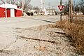
A view of downtown Cardin in 2008.
-
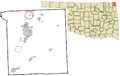
Location within Ottawa County and the state of Oklahoma showing former municipal boundaries
See also
 In Spanish: Cardin (Oklahoma) para niños
