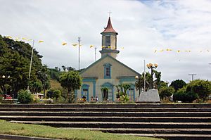
Carelmapu facts for kids
Quick facts for kids
Carelmapu
|
|
|---|---|

Church of Carelmapu
|
|
| Region | Los Lagos |
| Province | Llanquihue |
| Municipality | Maullín |
| Commune | Maullín |
| Government | |
| • Type | Municipal |
| Elevation | 5 m (16 ft) |
| Population
(2002)
|
|
| • Total | 2,903 |
| Time zone | UTC−04:00 (Chilean Standard) |
| • Summer (DST) | UTC−03:00 (Chilean Daylight) |
| Area code(s) | Country + town = 56 + 65 |
Carelmapu is a small port town in southern Chile. Its name comes from the Mapudungun language. It means "Green Land." Carelmapu is located at the western end of the Chacao Channel.
Contents
History of Carelmapu
Carelmapu has a long and interesting history. The Spanish founded the town in 1602. They named it San Antonio Ribera de Carelmapu. This happened after a big event called the Destruction of Seven Cities.
Early Challenges
In 1643, a Dutch pirate named Hendrick Brouwer attacked Carelmapu. He damaged the town and its church. Later, on March 6, 1676, Carelmapu welcomed tired explorers. These explorers were part of Pascual de Iriarte's expedition to the Strait of Magellan.
Carelmapu's Fort System
During colonial times, Carelmapu was protected by a small system of forts. This system included Fuerte de Carelmapu. It was just west of the town. There was also a lookout post called Astillero. And a cannon battery named Coronel.
Location of the Forts
Astillero and Coronel were not right in Carelmapu. They were further east. They were located along the northern shores of the Chacao Channel. The first Fuerte de Carelmapu was made of wood. It was built in 1603. Today, you can still find parts of it. But they are in poor condition.
See also
 In Spanish: Carelmapu para niños
 | Isaac Myers |
 | D. Hamilton Jackson |
 | A. Philip Randolph |

