
Carey Gully facts for kids
Quick facts for kids Carey GullySouth Australia |
|||||||||||||||
|---|---|---|---|---|---|---|---|---|---|---|---|---|---|---|---|

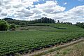
Strawberry farm in Carey Gully
|
|||||||||||||||

Carey Gully
Location in South Australia
|
|||||||||||||||
| Postcode(s) | 5144 | ||||||||||||||
| Location | 25.4 km (16 mi) E of Adelaide | ||||||||||||||
| LGA(s) | Adelaide Hills Council | ||||||||||||||
| Region | Adelaide Hills | ||||||||||||||
| County | Adelaide | ||||||||||||||
| State electorate(s) | Kavel | ||||||||||||||
| Federal Division(s) | Mayo | ||||||||||||||
|
|||||||||||||||
| Footnotes | Adjoining localities | ||||||||||||||
Carey Gully is a small town located in the beautiful Adelaide Hills region of South Australia. It's known for its peaceful countryside and lovely views.
The town gets its name from an early settler called Paddy Carey. It was originally known as Carey's Gully. Even though it's called a "gully," the main part of the town is actually on a ridge of the Mount Lofty Ranges. This ridge separates the valleys of Uraidla to the west and Balhannah to the east. The first settlements were in smaller gullies where the soil was good for farming.
Contents
What is Carey Gully Like Today?
Carey Gully has become a quieter place over the years. Some businesses, like the old general store and petrol station, have closed down. However, important services are still there.
The Country Fire Service station helps keep the community safe. There's also the Carey Gully Quarry and a small factory building. This factory houses businesses like boat building and traditional carpentry.
Main Roads and Past Times
Greenhill Road is the main road that runs through Carey Gully. This is where the town's current center is located. In the past, many important places were on Deviation Road, which is nearby.
Deviation Road was a great spot because it was mostly flat and dry. It was also a main route to towns like Forest Range and Lenswood. Long ago, Deviation Road had a football oval for Australian rules football and tennis courts. These are now strawberry fields! The old general store building is still there, but it's now a private home.
A Peaceful Place to Visit
Carey Gully is a very calm and charming place. Many people from nearby Adelaide come here to relax. The town is cooler in summer, which is a nice escape from the heat. It offers amazing views and quiet valleys, making it perfect for a weekend trip or a peaceful retirement.
Farming and Nature in Carey Gully
Farming is a very important part of life in Carey Gully. The area is famous for growing delicious fruits. You'll find farms with strawberries, apples, cherries, and even grapes for making wine.
Many people also have hobby farms here. They raise different animals like goats, sheep, cattle, and deer.
Protecting Nature
Even with all the farming, Carey Gully has kept a lot of its natural bushland. Like many towns in the Adelaide Hills, it's home to many special plants and animals. Some of these are rare or endangered.
Places like Wotton's Scrub and White's Scrub are great examples. They are part of the Kenneth Stirling Conservation Park, helping to protect this important natural environment.
Bushfires in the Area
Carey Gully has faced bushfires many times. One of the most significant events was the Ash Wednesday fires in 1983. The community has learned a lot about preparing for and managing bushfires since then.
Getting Around Carey Gully
Public transport in Carey Gully is provided by Adelaide Metro. Bus routes 821 and 822 connect the town to the City. Buses run about every two hours. Route 822 also links Carey Gully to nearby Stirling. During busy times, there are more services to and from the city.
Images for kids
-
Strawberry farm in Carey Gully
