Carmangay facts for kids
Quick facts for kids
Carmangay
|
|
|---|---|
|
Village
|
|
| Village of Carmangay | |
| Country | Canada |
| Province | Alberta |
| Region | Southern Alberta |
| Census division | 5 |
| Municipal district | Vulcan County |
| Incorporated | |
| • Village | January 20, 1910 |
| • Town | March 17, 1911 |
| • Village | March 4, 1936 |
| Area
(2021)
|
|
| • Land | 1.8 km2 (0.7 sq mi) |
| Elevation | 935 m (3,068 ft) |
| Population
(2021)
|
|
| • Total | 269 |
| • Density | 149.6/km2 (387/sq mi) |
| Time zone | UTC−7 (MST) |
| • Summer (DST) | UTC−6 (MDT) |
| Forward sortation area |
T0L 0N0
|
| Area code(s) | 403, 587, 825 |
| Highway | Highway 23 |
| Waterway | Little Bow River |
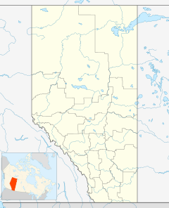
Carmangay (/ˈkɑːrmənɡeɪ/ kar-MƏN-gay) is a small village in southern Alberta, Canada. It is about 62 kilometers (38 miles) north of Lethbridge. It is also about 150 kilometers (93 miles) south of Calgary. The village is located along the Canadian Pacific Railway. It is also found east of Highway 23. Carmangay got its name from C.W. Carman and his wife, Gertrude Gay. Mr. Carman bought a large piece of land here in 1904 to grow wheat.
Contents
Exploring Carmangay's Past
Carmangay is home to a special place called the Carmangay Tipi Rings. This is an archaeological site. Tipi rings are circles of stones that were used to hold down the edges of tipis. These were homes used by Indigenous peoples.
Scientists have studied the Carmangay Tipi Rings. They found enough clues to guess when people lived there. They believe the site was used between 200 AD and 1700 AD.
How Many People Live in Carmangay?
Let's look at the population of Carmangay. This tells us how many people live there.
Recent Population Counts
- In the 2021 Census, 269 people lived in Carmangay.
- These people lived in 127 homes.
- This was a small increase from 242 people in 2016.
Carmangay's Size and Density
- The village covers a land area of 1.8 square kilometers (0.7 square miles).
- In 2021, there were about 149.6 people living in each square kilometer. This is called population density.
Powering the Future: Wind Energy
Carmangay is near a big project that helps make clean energy. This project is a wind farm.
The Blackspring Ridge Wind Project
- In 2013, two companies started building a large wind farm east of Carmangay.
- These companies were Enbridge and EDF.
- The wind farm has 166 tall wind turbines.
- Over 300 workers helped build this project.
- The project was finished in May 2014. It is called the Blackspring Ridge Wind Project.
- This wind farm can produce 300 megawatts of electricity. That's enough power for many homes!


