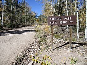
Carnero Pass facts for kids
Quick facts for kids Carnero Pass |
|
|---|---|

Carnero Pass
|
|
| Elevation | 10,166 ft (3,099 m) |
| Traversed by | Saguache County Road 41G (Unpaved road) |
| Location | Saguache County, Colorado, United States |
| Range | La Garita Mountains |
| Coordinates | 38°00′16″N 106°25′50″W / 38.0044416°N 106.4305896°W |
| Topo map | USGS Lake Mountain |
Carnero Pass is a mountain pass located in south-central Colorado. It sits high up in the La Garita Mountains, which are part of the larger San Juan Mountains range. This pass is like a natural pathway through the mountains, reaching an elevation of 10,166 feet (3,099 m) (that's over 3,000 meters!).
What is Carnero Pass?
Carnero Pass is found in Saguache County. It plays an important role by dividing the flow of water. To the north, water flows into Houselog Creek. To the south, it flows into Carnero Creek. Imagine it as a natural watershed divide! A road called County Road 41G goes right over Carnero Pass. This road is unpaved, meaning it's a dirt or gravel road, not paved with asphalt.
A Path Through Time
Carnero Pass has been an important route for a long time. The Utes, who are Native Americans, were among the first to use this pass. They, along with early trappers, created a trail over the pass by the mid-1800s. This trail helped them travel through the rugged mountains. By the 1870s, the trail was improved enough for wagons to use it. This made it easier for people to move goods and travel across the region.
 | Selma Burke |
 | Pauline Powell Burns |
 | Frederick J. Brown |
 | Robert Blackburn |

