
Carrick-a-Rede Rope Bridge facts for kids
Quick facts for kids Carrick-a-Rede Rope BridgeCarraig a'Ráid |
|
|---|---|
 |
|
| Coordinates | 55°14′24.13″N 6°19′51.76″W / 55.2400361°N 6.3310444°W |
| Locale | Ballintoy, County Antrim |
| Characteristics | |
| Design | simple suspension bridge |
| Material | rope |
| Total length | 20 metres (66 ft) |
| Height | 30 metres (98 ft) |
| Number of spans | 1 |
| Load limit | 8 pedestrians |
| History | |
| Constructed by | Heyn Construction |
| Opened | 2008 (current bridge) |
| Statistics | |
| Toll | £9 or €15 |
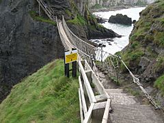
The Carrick-a-Rede Rope Bridge (say it "carrick-a-reed") is a cool rope bridge in Northern Ireland. It's found near Ballintoy in County Antrim. This bridge connects the mainland to a tiny island called Carrickarede. The island's name means "rock of the casting" in Irish.
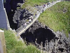
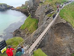
The bridge stretches 20 metres (66 ft) across the gap. It hangs 30 metres (98 ft) above the rocks below. Today, it's mostly a fun place for tourists to visit. The National Trust owns and takes care of it. In 2018, nearly half a million people visited the bridge. You can cross it all year round, if the weather is good, but you need to pay a small fee.
Contents
History of the Rope Bridge
_(LOC)_(4426684715).jpg)
People believe that salmon fishermen first built bridges to the island over 350 years ago. The bridge has changed a lot over time. In the 1970s, it was quite scary. It only had one handrail and big gaps between the wooden steps!
A much safer bridge was built in 2000. Local climbers and abseilers helped to build it. This new bridge could hold up to ten tonnes. Another new bridge was put up in 2004. It made crossing to the island much safer for everyone.
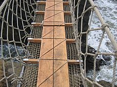
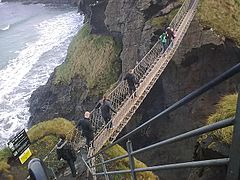
The bridge you see today was built in 2008. It uses strong wire ropes and Douglas fir wood. Heyn Construction in Belfast made it. It cost over £16,000 to build. Sometimes, visitors get scared to walk back across the bridge. They have to be taken off the island by boat instead!
In May 2017, the bridge was damaged. Someone had vandalized its ropes. The National Trust closed it for a short time. But engineers quickly fixed it, and it reopened the very next day.
Fishing at Carrick-a-Rede
Fishermen no longer use the bridge during salmon season. This season used to run from June to September. Sadly, there are very few salmon left now. In the 1960s, fishermen caught almost 300 fish every day. But by 2002, only 300 fish were caught in the whole season. The salmon used to swim through this area to lay their eggs. They would go to the River Bann and the River Bush.
Cool Features and Views
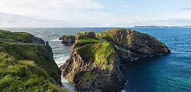
From the bridge area, you can see amazing views. You can spot Rathlin Island and even Scotland on a clear day! This whole area is special. It's called an Area of Special Scientific Interest. This is because of its unique rocks, plants, and animals.
Underneath the bridge, there are large caves. Long ago, these caves were used by boat builders. They also offered shelter during stormy weather.
How the Island Was Formed
Carrickarede island is a great example of a volcanic plug in Northern Ireland. Imagine an old volcano. Over time, ocean erosion has worn away the land. This has shown us the inside of the volcano's neck.
You can see different types of volcanic rock here. These include tuff, explosion breccias, and explosion bombs. These rocks show how powerful the eruptions were. This happened about 60 million years ago. That's when hot, melted rock pushed its way through chalk.
Along this coast, the cliffs are mostly made of basalt. Underneath the basalt, you find the white Ulster chalk. At Carrickarede, the old volcanic pipe left behind a harder rock called dolerite. Dolerite wears away slower than basalt. Behind the dolerite, the volcano's vent is filled with softer rocks. These are called pyroclastic rocks, mostly a coarse tuff agglomerate. The mix of hard rock in front and softer rock behind, plus years of waves, created this small island.
Gallery
-
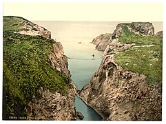
A Photochrom picture of the Bridge, from around 1890
-
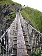
The bridge structure in 2004
-
The bridge structure in 2005
-
Carrick-a-Rede Rope Bridge, 2006
-
Carrick-a-Rede Rope Bridge, 2007
-
The bridge being used in 2010
-
A view of the bridge and island
-
The bridge in 2017


See also
 In Spanish: Puente de cuerda Carrick-a-Rede para niños
